
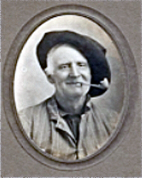
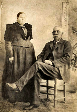

Hiram Anthony Richard Hendrix
| Birth | : | 27 Jan 1846 Springfield, Sangamon County, Illinois, USA |
| Death | : | 30 May 1910 Lexington, Dawson County, Nebraska, USA |
| Burial | : | Carlyle Cemetery, Rutherglen, Indigo Shire, Australia |
| Coordinate | : | -36.0387710, 146.4040340 |
| Plot | : | Block 16; Div. F; Lot 3; Space 3 |
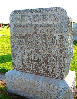
| Inscription | : | HENDRIX FATHER HIRAM A. JAN 27, 1846 MAY 30, 1910 ---- MOTHER NANCY AUG. 17, 1849 FEB. 21, 1928 AT REST |
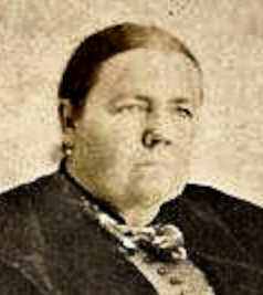
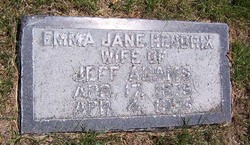
| Description | : | Son of Samuel W. Hendrix and Mary Elizabeth Neville. He was called "Dick" by friends. He married Nancy Adeline Blue in Sangamon County, Illinois, January 2, 1866. She was the daughter of Robert Blue and Martha Blue (cousins). They were farmers. In 1880 they were living in Austin, Macon, Illinois, and by 1900 they were living in Lexington where they remained. They had the following children: 1. Katharine "Katie" Hendrix who ~m~ Demaine Gordon 2. Ethel Hendrix ~m~ Mr. Heiter 3. John H. Hendrix ~m~ Anna Belle Sprague 4. Emily Jane "Emma" Hendricks ~m~ Merrill Jefferson Adams 5. Mary E. Hendrix ~m~ Robert... Read More |
frequently asked questions (FAQ):
-
Where is Hiram Anthony Richard Hendrix's memorial?
Hiram Anthony Richard Hendrix's memorial is located at: Carlyle Cemetery, Rutherglen, Indigo Shire, Australia.
-
When did Hiram Anthony Richard Hendrix death?
Hiram Anthony Richard Hendrix death on 30 May 1910 in Lexington, Dawson County, Nebraska, USA
-
Where are the coordinates of the Hiram Anthony Richard Hendrix's memorial?
Latitude: -36.0387710
Longitude: 146.4040340
Family Members:
Parent
Spouse
Siblings

Children
Flowers:


Nearby Cemetories:
1. Carlyle Cemetery
Rutherglen, Indigo Shire, Australia
Coordinate: -36.0387710, 146.4040340
2. Corowa Pioneer Cemetery
Corowa, Federation Council, Australia
Coordinate: -36.0049360, 146.3818130
3. Corowa War Memorial
Corowa, Federation Council, Australia
Coordinate: -35.9942300, 146.3911780
4. Corowa Lawn Cemetery
Corowa, Federation Council, Australia
Coordinate: -35.9935990, 146.3685040
5. Ullina Station Cemetery
Chiltern Valley, Indigo Shire, Australia
Coordinate: -36.1370500, 146.5185070
6. Hopefield Cemetery
Hopefield, Federation Council, Australia
Coordinate: -35.8789500, 146.4389000
7. Chiltern Old Cemetery
Chiltern, Indigo Shire, Australia
Coordinate: -36.1649400, 146.5676700
8. Chiltern Cemetery
Chiltern, Indigo Shire, Australia
Coordinate: -36.1443100, 146.5922600
9. Springhurst Cemetery
Springhurst, Wangaratta Rural City, Australia
Coordinate: -36.2252950, 146.4683470
10. Howlong Cemetery
Howlong, Federation Council, Australia
Coordinate: -35.9959400, 146.6485100
11. Peechelba Cemetery
Moira Shire, Australia
Coordinate: -36.1729760, 146.2162470
12. Chiltern Pioneer Cemetery
Chiltern, Indigo Shire, Australia
Coordinate: -36.1102500, 146.6414100
13. Boorhaman Cemetery
Boorhaman, Wangaratta Rural City, Australia
Coordinate: -36.2272970, 146.2726610
14. Barnawartha Cemetery
Barnawartha, Indigo Shire, Australia
Coordinate: -36.1114290, 146.6661640
15. Bundalong Cemetery
Bundalong, Moira Shire, Australia
Coordinate: -36.0241430, 146.1046500
16. Bontharambo Cemetery
Boorhaman, Wangaratta Rural City, Australia
Coordinate: -36.2877780, 146.3011110
17. Goombargana Cemetery
Brocklesby, Greater Hume Shire, Australia
Coordinate: -35.7973100, 146.5765600
18. El Dorado Cemetery
Eldorado, Wangaratta Rural City, Australia
Coordinate: -36.3127800, 146.5212500
19. Moorwatha Cemetery
Moorwatha, Federation Council, Australia
Coordinate: -35.9017860, 146.7238260
20. Bungowannah Cemetery
Bungowannah, Greater Hume Shire, Australia
Coordinate: -35.9971540, 146.7843930
21. Yarrawonga Cemetery
Yarrawonga, Moira Shire, Australia
Coordinate: -36.0236010, 146.0114210
22. Wangaratta Pioneer Cemetery
Wangaratta, Wangaratta Rural City, Australia
Coordinate: -36.3546662, 146.3299177
23. Mulwala Cemetery
Mulwala, Federation Council, Australia
Coordinate: -35.9888751, 145.9973446
24. Wilby Cemetery
Wilby, Moira Shire, Australia
Coordinate: -36.1644100, 146.0098710