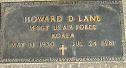
Howard Dean Lane
| Birth | : | 11 May 1930 Newell, Buena Vista County, Iowa, USA |
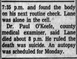
| Death | : | 24 Jul 1981 Gladstone, Clay County, Missouri, USA |
| Burial | : | Newell Cemetery, Newell, Buena Vista County, USA |
| Coordinate | : | 42.6123800, -94.9994800 |
| Plot | : | D-50 |
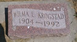
| Description | : | Howard Dean Lane, 51, of Gladstone, Missouri, formerly of Newell, died Friday, July 24, 1981 at his home. He was born May 11, 1930, at Newell, Iowa, son of James and Wilma Witzke Lane. He was baptized August 31, 1930 and later confirmed in the Lutheran Church at Newell. He married Mazine Chuning September 7, 1964 at Minnesota. They were later divorced. He served in the Air Force for 22 years serving in Okinawa, Korea and Greenland, retiring in 1969. He was employed as a truck driver for DAW Transport in Kansas City, Kansas. He had worked for them since he retired from the Air Force. He was preceded in death by his father, James, in 1942, and a brother, James, in... Read More |
frequently asked questions (FAQ):
-
Where is Howard Dean Lane's memorial?
Howard Dean Lane's memorial is located at: Newell Cemetery, Newell, Buena Vista County, USA.
-
When did Howard Dean Lane death?
Howard Dean Lane death on 24 Jul 1981 in Gladstone, Clay County, Missouri, USA
-
Where are the coordinates of the Howard Dean Lane's memorial?
Latitude: 42.6123800
Longitude: -94.9994800
Family Members:
Parent
Siblings
Flowers:
Nearby Cemetories:
1. Newell Cemetery
Newell, Buena Vista County, USA
Coordinate: 42.6123800, -94.9994800
2. Newell Catholic Prairie Cemetery
Newell, Buena Vista County, USA
Coordinate: 42.6144000, -95.0328000
3. Donna Lynn Salis-Christensen Burial Plot
Newell, Buena Vista County, USA
Coordinate: 42.5882134, -95.0544960
4. Varina Cemetery
Newell Township, Buena Vista County, USA
Coordinate: 42.6539993, -94.9339981
5. Saint Johns Church Of Christ Cemetery
Storm Lake, Buena Vista County, USA
Coordinate: 42.7108002, -95.0428009
6. Saint John's Lutheran Cemetery
Albert City, Buena Vista County, USA
Coordinate: 42.7200920, -94.9947630
7. Zion Lutheran Cemetery
Storm Lake, Buena Vista County, USA
Coordinate: 42.7136002, -95.0650024
8. Saint Columbkilles Cemetery
Varina, Pocahontas County, USA
Coordinate: 42.6467018, -94.8443985
9. Nemaha Cemetery
Nemaha, Sac County, USA
Coordinate: 42.5102997, -95.0905991
10. Cedar Township Cemetery
Fonda, Pocahontas County, USA
Coordinate: 42.5810000, -94.8375000
11. Saint Mary's Catholic Cemetery
Storm Lake, Buena Vista County, USA
Coordinate: 42.6470000, -95.1660000
12. Mount Zion Cemetery
Fonda, Pocahontas County, USA
Coordinate: 42.5821991, -94.8300018
13. Storm Lake Cemetery
Storm Lake, Buena Vista County, USA
Coordinate: 42.6352800, -95.1744400
14. Dover Township Cemetery
Varina, Pocahontas County, USA
Coordinate: 42.6896100, -94.8524200
15. Lincoln Township Cemetery
Buena Vista County, USA
Coordinate: 42.7413000, -95.1282000
16. Fairfield Cemetery
Albert City, Buena Vista County, USA
Coordinate: 42.7783012, -94.9692001
17. Saint John Cemetery
Williams Township, Calhoun County, USA
Coordinate: 42.4747009, -94.8672028
18. Marshall Cemetery
Pocahontas County, USA
Coordinate: 42.7633018, -94.8930969
19. Buena Vista Memorial Park Cemetery
Storm Lake, Buena Vista County, USA
Coordinate: 42.6539001, -95.2339020
20. Cedar Cemetery
Sac City, Sac County, USA
Coordinate: 42.4430000, -94.9110000
21. Sacred Heart Cemetery
Early, Sac County, USA
Coordinate: 42.4650002, -95.1446991
22. Immanuel Reformed Cemetery
Schaller, Sac County, USA
Coordinate: 42.5396996, -95.2294006
23. Oakland Cemetery
Sac City, Sac County, USA
Coordinate: 42.4272100, -94.9910760
24. Early Union Cemetery
Early, Sac County, USA
Coordinate: 42.4578018, -95.1425018


