

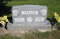
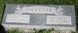
Howard James “Bud” Taylor Sr.
| Birth | : | 23 May 1920 Niobrara, Knox County, Nebraska, USA |
| Death | : | 19 Nov 2002 Alliance, Box Butte County, Nebraska, USA |
| Burial | : | Oakwood Cemetery, Lowell, Kent County, USA |
| Coordinate | : | 42.9449997, -85.3377991 |
| Description | : | Married Maxine Flatley on January 3, 1946. |
frequently asked questions (FAQ):
-
Where is Howard James “Bud” Taylor Sr.'s memorial?
Howard James “Bud” Taylor Sr.'s memorial is located at: Oakwood Cemetery, Lowell, Kent County, USA.
-
When did Howard James “Bud” Taylor Sr. death?
Howard James “Bud” Taylor Sr. death on 19 Nov 2002 in Alliance, Box Butte County, Nebraska, USA
-
Where are the coordinates of the Howard James “Bud” Taylor Sr.'s memorial?
Latitude: 42.9449997
Longitude: -85.3377991
Family Members:
Parent
Spouse
Siblings
Children
Flowers:


Nearby Cemetories:
1. Oakwood Cemetery
Lowell, Kent County, USA
Coordinate: 42.9449997, -85.3377991
2. Saint Mary Cemetery
Lowell, Kent County, USA
Coordinate: 42.9547005, -85.3522034
3. Foxes Cemetery
Lowell, Kent County, USA
Coordinate: 42.9555560, -85.3533330
4. Wright Cemetery
Lowell, Kent County, USA
Coordinate: 42.9435997, -85.3816986
5. Fallas Cemetery
Vergennes Township, Kent County, USA
Coordinate: 42.9844017, -85.3191986
6. McBride Cemetery
Lowell, Kent County, USA
Coordinate: 42.8993988, -85.3358002
7. Krum Blanding Cemetery
Lowell, Kent County, USA
Coordinate: 42.9580994, -85.4011002
8. Pinckney Cemetery
Saranac, Ionia County, USA
Coordinate: 42.9655991, -85.2619019
9. Bailey Cemetery
Lowell, Kent County, USA
Coordinate: 42.9735610, -85.4106440
10. Roth Coons Cemetery
Lowell, Kent County, USA
Coordinate: 42.9272003, -85.4263992
11. White Cemetery
Saranac, Ionia County, USA
Coordinate: 42.9435997, -85.2403030
12. Alton Cemetery
Lowell, Kent County, USA
Coordinate: 43.0169440, -85.3505560
13. South Boston Cemetery
Clarksville, Ionia County, USA
Coordinate: 42.8866005, -85.2777023
14. Marble Cemetery
Saranac, Ionia County, USA
Coordinate: 43.0017014, -85.2731018
15. Snow Cemetery
Cascade, Kent County, USA
Coordinate: 42.9077830, -85.4306420
16. Merriman Cemetery
Alto, Kent County, USA
Coordinate: 42.8706017, -85.3827972
17. Saranac Cemetery
Saranac, Ionia County, USA
Coordinate: 42.9289160, -85.1987720
18. Saint Patrick Cemetery
Ada, Kent County, USA
Coordinate: 43.0419440, -85.4097220
19. Saint Marys Catholic Cemetery
Smyrna, Ionia County, USA
Coordinate: 43.0374420, -85.2530800
20. DeVos Family Memorial Garden
Ada, Kent County, USA
Coordinate: 42.9493690, -85.4913280
21. Carmelite Cemetery
Parnell, Kent County, USA
Coordinate: 43.0431430, -85.4192810
22. Forest Hills Presbyterian Church Columbarium
Cascade Township, Kent County, USA
Coordinate: 42.8981194, -85.4814083
23. Mason Cemetery
Grattan Township, Kent County, USA
Coordinate: 43.0611000, -85.3321991
24. Cascade Cemetery
Cascade Township, Kent County, USA
Coordinate: 42.9088890, -85.4905560