
| Birth | : | 21 Jul 1920 Greenville County, South Carolina, USA |
| Death | : | 17 Nov 2008 South Carolina, USA |
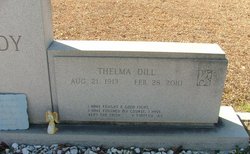
| Burial | : | Oroville Riverview Cemetery, Oroville, Okanogan County, USA |
| Coordinate | : | 48.9202700, -119.4458500 |
| Description | : | Hoyt Max Dill, 88, formerly of 1505 Groce Meadow Road, widower of Ellie Rollins Dill, died November 17, 2008, at Piedmont Living Center. A native of Greenville County, son of the late Perry Earl and Lizzie Gibson Dill, he was a U.S. Army veteran of World War II, a retired diesel mechanic and of the Baptist faith. Surviving are a daughter, Maxine D. Howell of Greer; a sister, Thelma Eaddy of Johnsonville, S.C.; three grandchildren, Kimberly Box and her husband, Eddie, of Maryville, Tenn., Rachel Rashad and her husband, Mohamed of Alexandria, Egypt and Michael Howell and his wife, Janet, of Taylors;... Read More |
frequently asked questions (FAQ):
-
Where is Hoyt M Dill's memorial?
Hoyt M Dill's memorial is located at: Oroville Riverview Cemetery, Oroville, Okanogan County, USA.
-
When did Hoyt M Dill death?
Hoyt M Dill death on 17 Nov 2008 in South Carolina, USA
-
Where are the coordinates of the Hoyt M Dill's memorial?
Latitude: 48.9202700
Longitude: -119.4458500
Family Members:
Parent

Spouse
Siblings
Children
Flowers:


Nearby Cemetories:
1. Oroville Riverview Cemetery
Oroville, Okanogan County, USA
Coordinate: 48.9202700, -119.4458500
2. Old Riverview Cemetery
Oroville, Okanogan County, USA
Coordinate: 48.9177800, -119.4466700
3. Old Oroville Cemetery
Okanogan County, USA
Coordinate: 48.8913360, -119.4456230
4. Golden Cemetery
Okanogan County, USA
Coordinate: 48.9014015, -119.5203018
5. Mountain View Memorial Cemetery
Ellisforde, Okanogan County, USA
Coordinate: 48.8328300, -119.4011300
6. Ellisforde Mission Cemetery
Ellisforde, Okanogan County, USA
Coordinate: 48.7908300, -119.3972300
7. Mountain View Cemetery
Loomis, Okanogan County, USA
Coordinate: 48.8152700, -119.6100100
8. Osoyoos Lakeview Cemetery
Osoyoos, Okanagan-Similkameen Regional District, Canada
Coordinate: 49.0638600, -119.5185500
9. Little Chopaka Cemetery
Okanogan County, USA
Coordinate: 48.8272200, -119.6430600
10. Molson Cemetery
Molson, Okanogan County, USA
Coordinate: 48.9657000, -119.2105000
11. Sidley-Lawless Cemetery
Sidley, Kootenay Boundary Regional District, Canada
Coordinate: 49.0153330, -119.2234330
12. Immanuel Lutheran Cemetery
Havillah, Okanogan County, USA
Coordinate: 48.8305500, -119.2033500
13. Kipling Cemetery
Okanogan County, USA
Coordinate: 48.9080500, -119.1652900
14. Tonasket Cemetery
Tonasket, Okanogan County, USA
Coordinate: 48.7284400, -119.4328200
15. Valley Congregational Church Memorial Rose Garden
Oliver, Okanagan-Similkameen Regional District, Canada
Coordinate: 49.1169070, -119.5575920
16. Bridesville Cemetery
Bridesville, Kootenay Boundary Regional District, Canada
Coordinate: 49.0370800, -119.1372300
17. Chesaw Cemetery
Okanogan County, USA
Coordinate: 48.9299900, -119.0541800
18. Oliver Cemetery
Oliver, Okanagan-Similkameen Regional District, Canada
Coordinate: 49.1767600, -119.5697000
19. Fairview Cemetery
Fairview, Okanagan-Similkameen Regional District, Canada
Coordinate: 49.1742600, -119.5998800
20. Thorp Cemetery
Chesaw, Okanogan County, USA
Coordinate: 48.9549900, -119.0316700
21. Anglin Cemetery
Okanogan County, USA
Coordinate: 48.6627700, -119.2783400
22. Phillip Raux Gravesite
Riverside, Okanogan County, USA
Coordinate: 48.6271800, -119.3308500
23. Wauconda Cemetery
Wauconda, Okanogan County, USA
Coordinate: 48.7408300, -119.0597300
24. Pine Creek Cemetery
Tonasket, Okanogan County, USA
Coordinate: 48.6330560, -119.6502780