| Description |
: |
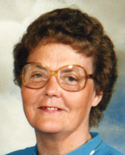
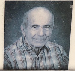
History of Ileen (Ockey) Parker
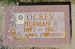
Ileen is the daughter of Herman Russell Ockey, who was the son of John Edward Ockey and Eliza Maria Russell. Her mother is Thelma Wynder Ockey, daughter of Victor Charles Wynder and May Wright. Ileen was born 15 Oct 1927 at Cardston, Alberta, Canada.
I grew up on a farm east of Stavely where we farmed and raised pigs, cows, and chickens etc. We farmed with horses and later Dad got a tractor. I helped Dad when I was old enough to do stooking etc. We would follow Dad...
Read More
|
History of Ileen (Ockey) Parker
Ileen is the daughter of Herman Russell Ockey, who was the son of John Edward Ockey and Eliza Maria Russell. Her mother is Thelma Wynder Ockey, daughter of Victor Charles Wynder and May Wright. Ileen was born 15 Oct 1927 at Cardston, Alberta, Canada.
I grew up on a farm east of Stavely where we farmed and raised pigs, cows, and chickens etc. We farmed with horses and later Dad got a tractor. I helped Dad when I was old enough to do stooking etc. We would follow Dad around in the fields while he was plowing or cutting the grain. What ambition we had. Our house was small for such a large family but we managed and Mother and Dad were hard workers. Dad had to go out to work and Mother carried on at home trying to get us kids to work.
Memories I can remember are raking the yards in the spring and enjoying the cleanness, the big swing in our yard we used to swing on, the water trough the cattle drank from and we would swim in. The windmill that pumped the water, the mice that used to get in the well and we would finally pump it up. The dust storms we would have, thunder and lightnings and hail and Mother getting us on the beds and away from the windows. Going to Calgary with Mother and Dad and staying in hotels. Cold winters and heating rocks to keep our feet warm.
School was a one room building with a pot belly stove. I had a teacher, Mrs. Jenkins, until we went to Stavely for grade 10 and 11 where we had many teachers but I can't remember their names. I didn't like school very well as I couldn't seem to be able to learn as well as the others. I have fond memories of all the Christmas programs Mrs. Jenkins put on with us all taking part. We walked to school for 9 Years and then we only walked one and a half miles to the corner where we caught a ride with a neighbor, Margueritte Clancy, who worked in town. We would walk home sometimes when the weather was good and someone might pick us up and take us home. While going to the country school, Pine Coulee, we did the janitor work to earn a bit of money.
While in grade eleven our family moved to Rosemary and I never went to school again. I helped Dad farm and got jobs doing housework. I enjoyed dancing and going to shows with Mother and Dad and later with many boy friends. I didn't seem to have much trouble having dates.
I met Norman before he went on his mission and half waited for him. I went out with others but in my mind felt I was going to marry him if he didn't change his mind. I worked in Linquist's store while he was gone and when he came home in June we courted until November. We went to the Cardston Temple November 3rd 1949 to be married. We honeymooned at Lethbridge and Calgary then home.
We built our first home that first winter. A two roomed house on his folks farm. I raised a garden and canned. Delbert came 16 July 1950 and that fall in October we went to live in Woodscross Utah living with Velma and Merwin Norman's sister. We came home in Feb 1951 and have lived in Canada since.
We moved in April, 1953 to Orton, Alberta in Norman's folks old home. We had 3 children then. We have lived here in Orton bringing eight more children into the world and raised them here. We have sent 7 boys on missions and now have 8 children married and sealed to their companions. We have 26 grandchildren and 2 on the way. We have struggled at farming and Norman had to go out working in the labor force. We are now hoping to sustain ourselves from money we got from selling a quarter section of land. With the way prices are it may not be so easy.
I have had many positions in the church from Visiting Teacher, Primary President, Junior Sunday School Coordinator, councillor in the Relief Society, Secretary, Librarian etc. Each position has helped me to grow in the gospel and to learn what it is I believe and to help me raise our family. Norman and I and Andrea are the only ones left at home. I am enjoying working in the French Extraction and Ward Library. I would like to do some painting and I have tried my hand at it a bit and get quite flustered when I can't get it to look like I want. I enjoy fooling around playing the piano, crocheting and doing a bit of quilting.
Pam, LaVar and Valerie and Reed and their families live close by. I enjoy them dropping in and going on picnics etc. Others of our children Delbert, Marvin, Bryce and Gary are living in the USA and we visit them periodically. Gregory is our last son to go on a mission and we are ever grateful that they went and hope they won't forget the testimonies they got while there.
I am ever grateful for my membership in the LDS Church and for the things that I believe. For a good companion and for eleven loving children and 26 healthy grandchildren. I am grateful for a Mother who went without to provide for her children and who taught us correct principles and for a Dad who struggled to provide for us and shared his musical talents along with mothers.
This is an update of the above history that I wrote in 1991. Our last daughter Andrea was married and later they had identical twin girls which was a shock but neat. They named them Mckenzie and Kiara. Five moths later Dané and Greg had twins, a boy and a girl naming them Bradley and Breann. The past three winters we have been in Mesa Arizona where we bought a trailer and lived in it.
We have had adversity come into our family. Lana divorced Delbert and Pam divorced Murray. Some of our grandchildren have followed the ways of the world. It makes us sad but we all have our agency and we all make mistakes but thank goodness for repentance. We have had more grandchildren added to our posterity. We now have 56 grandchildren. We have had 3 grandchildren get married and now have 3 great grand children. We decided we needed to follow the prophets advice and go on a mission. In 1994 we were called to the Melbourne Australia Mission. We left in the spring in June and spent a week in the Provo Utah which was a spiritual experience. We were taught how to present the gospel and talk to people. There were times I wished I wasn't there when it was my turn to ask questions or explain something. We had a good flight to Australia and was met by the Mission President. He sent us to the Mission Home with the Elders. There were two Elders also assigned to the same Mission. We were given a meal and they showed us a room with a bed and we went to sleep. The Mission President and his wife were going to be busy that evening so they told us where the food was and the TV etc. They told us to enjoy ourselves. We laid down and slept until 2 in the morning. We woke up, and now, what to do. We read scriptures and went back to sleep and just waited for morning.
They fed us breakfast and then took us to the outskirts of Melbourne and gave us a car with the steering wheel on the right hand of the car and told us to follow the road to Shepparton where a missionary couple there would meet us on the outskirts of town. It was scary as we were driving on the left side of the road. We arrived safely and the couple met us and showed us around and gave us tips on driving in Australia. We were in Shepparton for 11 months. We helped in the branch and visited the inactive and tried to share the gospel to any who would listen. I always wanted to do more than we did but didn't know how and I guess the Lord didn't feel he should put it into our minds what else to do. Probably our faith wasn't strong enough. The people were good to us and made us welcome and we learned to love each one. Roxanne and her father returned back to church while we were there. We spent the rest of our mission in the Albury-Wodonga area. I am not sure if we made any difference to anyone's life. We tried our best. We worked with the missionaries and met many people and learned to love them also. It is good to return home and get acquainted with grand children and family again. We are enjoying gardening and camping and going to family reunions. Since returning we have many decision's to make and it is a continual struggle to keep on the correct path to our Heavenly Father as there are many things in life that subtly lead one from our eternal goal. My constant prayer is to be able to endure to the end.
Update 2002
In 1997 we sold our farm to Gary and Melody Parker, our son. They moved in, in July. We had quite a jumble with their possessions and ours still in the house. We packed up ours and took them to our Daughter Pam's house in Fort Macleod. We didn't have anywhere to go. We had bought a 16 foot trailer and a truck and a car when we came home from our mission and so we set up our trailer in the yard and lived in that till we could find a place to live. We had been looking in Cardston for a place but had not found anything we liked or the price. We had Charlyn who lives in Cardston keeping her eyes out for us. She knew of a man who was sick and near death and his wife couldn't get around too well so she approached them to see if they were going to sell. They hadn't thought of it but said they would let her know if they did. It wasn't long and they said they were selling and we went and looked at it and the price was better than what we had been looking at and the home was well kept and so we bought it. We lived in the trailer till September then we moved to Cardston and have enjoyed both the home and Cardston.
When we first moved here we went to the senior Centre and played rook every Tues. but then Norman got interested in basketball and later football and softball and it seemed they were played on Tues. so we stopped going. We go to the Senior Centre every third Monday for potluck dinners and a program. I served on the Senior Centre board for 2 years. I was to represent the craft, which included the quilting that was done every Monday. The lady that had been in charge before didn't want to go to the meetings every month so that was what I did. I quite enjoyed doing it even though I didn't have too much input to give.
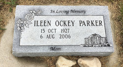
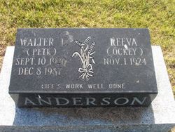
When we first came here we were called to do sealings in the temple. A year later we were called to be ordinance workers and we've been doing that ever since and we sub for others quite often. Norman and I were called to teach Sunday school lessons to the people in the Chinook, a home for seniors. I was doing that for 2 years. Norman was called to another position. Its been good to be close to Mother and I go see her often especially when Norman is at his sports events. I had a slight stroke 26 May 1998 and my brother Rex died on 29 July 1998 of kidney cancer. Mother had had a couple of slight strokes and gradually got so she couldn't be by herself a year ago. Reeva my sister had her stay with her for a month then she came and lived with us for a month. Kaaren took her for awhile as Reeva and I was going to be away. She fell while she was there and so we couldn't take care of her. We put her in the auxiliary hospital. She was gradually healing and getting along good when she fell again in Aug. I think and from that time on she gradually started down hill. She more or less starved herself to death, as she didn't like anything they fed her and refused to eat most things. We, Reeva, Verene, who had moved here in July 2000, Kaaren and myself visited and stayed with her everyday and watched her dwindle away. She died 19 March 2002 and she was buried 23 March 2002 in the Beazer cemetery We will miss her greatly. Our cousin Pearl Gallup passed away last July and we miss her as we used to go camping and play cards with her and Scott.
I'm doing French extraction and trying to do some every day. They have me teaching in the primary first the 11-12 years old and now the 7-8 year olds. I go twice a month and work in the auxiliary store at the hospital.
We've had grandchildren get married and now we have 7 great grand children. Andrea's baby is 2 years old and they are planning on moving from Hinton where they are living now and moving to Kelowna. Dané kicked Gregory out and we are praying things will turn out there somehow. We have had 6 grand children go on Missions and hope the rest will prepare and go. We have 57 grand children which includes Debbie's 3.
We are continually praying for our family. We pray they will choose the right and be able to resist the temptations placed before them. We love them all.
March 2004.
This is an update . We are well and keeping busy. We are still ordinance workers and do a lot of subbing for other people.. I am still working twice a week at the auxiliary store. I'm not teaching anymore but
am a supervisor for visiting teaching (people report to me when they have done their teaching). I am also a visiting teacher again. We are expecting 5 great grandchildren this year, in fact 3 have been born already . Susan and Bill Douglas (Val and Cal's girl) had a boy 15 March calling him Jaxon Charles.
On Feb 15 Terisa and Christian Mora (their oldest girl had a baby girl called her Madison Mae. The 16 March Ingrid and Michael Beazer had a girl naming her Eloise Margarita Bauer Beazer, The Bauer being Ingrid's maiden name. Scott and Taralyn Parker are expecting in April and Jennifer and J. J. Nelson , Bryce's boy and girl are expecting in May. So our flock is growing. Debbie's youngest girl had a boy a while back. There will be 5 baptisms this year also. Daniel, Gary's boy, Robert, Julie's boy, Harmon, Andrea's boy, Morgan , Marvin's girl, and Kristi's girl Skyler. Spring is in the air and the tulips are up and I am getting anxious to clean up our yard and do gardening and hope my health will let me . My testimony has strengthened as we are reading the Book Of Mormon as a stake and also we study it in family home evening. Love you all.
|