
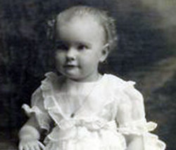

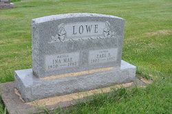
Ina Mae Walker Lowe
| Birth | : | 21 Jun 1920 Iowa, USA |
| Death | : | 17 Jul 1965 Mount Pleasant, Henry County, Iowa, USA |
| Burial | : | Brown Cemetery, Donegal Township, Westmoreland County, USA |
| Coordinate | : | 40.1016998, -79.4064026 |
| Description | : | The Burlington Hawk-Eye, page 3, July 18, 1965, Des Moines, Iowa Mt. Pleasant (IA). - Mrs. Earl Lowe of Crawfordsville died in Memorial Hospital here at 2:30pm Saturday July 17, 1965. Born June 21, 1920 she was the daughter of Mr. and Mrs Earl Walker of Crawfordsville. Surviors are her husband, two sons, Wayne and Alan, and a daughter Patricia, all at home. Services will he be held at the Methodist church in Crawfordsville Monday at 2pm. |
frequently asked questions (FAQ):
-
Where is Ina Mae Walker Lowe's memorial?
Ina Mae Walker Lowe's memorial is located at: Brown Cemetery, Donegal Township, Westmoreland County, USA.
-
When did Ina Mae Walker Lowe death?
Ina Mae Walker Lowe death on 17 Jul 1965 in Mount Pleasant, Henry County, Iowa, USA
-
Where are the coordinates of the Ina Mae Walker Lowe's memorial?
Latitude: 40.1016998
Longitude: -79.4064026
Family Members:
Parent

Spouse
Children
Flowers:


Nearby Cemetories:
1. Brown Cemetery
Donegal Township, Westmoreland County, USA
Coordinate: 40.1016998, -79.4064026
2. Keslar Cemetery
Fayette County, USA
Coordinate: 40.0995100, -79.4145100
3. Donegal Cemetery
Donegal, Westmoreland County, USA
Coordinate: 40.1112000, -79.3785000
4. Hays Cemetery
Mount Pleasant, Westmoreland County, USA
Coordinate: 40.1259000, -79.4021000
5. Walnut Hill Cemetery
Donegal, Westmoreland County, USA
Coordinate: 40.1040000, -79.3659000
6. Eutsey Cemetery Old
Fayette County, USA
Coordinate: 40.0781400, -79.4427900
7. Porch Cemetery
Donegal, Westmoreland County, USA
Coordinate: 40.1306000, -79.3711014
8. Byerly Freeman Cemetery
Mount Pleasant, Westmoreland County, USA
Coordinate: 40.1432500, -79.4100900
9. Eutsey Cemetery
Fayette County, USA
Coordinate: 40.0742400, -79.4474900
10. Melcroft Cemetery
Fayette County, USA
Coordinate: 40.0561000, -79.3829000
11. Knopsnider Cemetery New
Bullskin Township, Fayette County, USA
Coordinate: 40.0685400, -79.4686800
12. Knopsnider Cemetery (Old)
Bullskin Township, Fayette County, USA
Coordinate: 40.0691400, -79.4704800
13. Stouffer Cemetery
Bullskin Township, Fayette County, USA
Coordinate: 40.0848990, -79.4816900
14. Saint Raymonds Cemetery
Melcroft, Fayette County, USA
Coordinate: 40.0572014, -79.3531036
15. Mount Nebo Cemetery
Indian Head, Fayette County, USA
Coordinate: 40.0531000, -79.3556000
16. Dan Snyder Cemetery
Fayette County, USA
Coordinate: 40.0408000, -79.4317000
17. Mellinger Cemetery
Mellingertown, Westmoreland County, USA
Coordinate: 40.1432050, -79.4784730
18. Nicholson Cemetery
Clinton, Fayette County, USA
Coordinate: 40.0506100, -79.4745600
19. Good Hope Lutheran Cemetery
Fayette County, USA
Coordinate: 40.0282000, -79.3893900
20. Lobingier Cemetery
Mount Pleasant Township, Westmoreland County, USA
Coordinate: 40.1439030, -79.4887870
21. Franklin Lutheran Cemetery
Kregar, Westmoreland County, USA
Coordinate: 40.1215000, -79.3085000
22. Sparks Cemetery
Indian Head, Fayette County, USA
Coordinate: 40.0239200, -79.3892500
23. Brothers Cemetery
Fayette County, USA
Coordinate: 40.1360700, -79.5004300
24. Fairview Cemetery
Kecksburg, Westmoreland County, USA
Coordinate: 40.1696000, -79.4634000