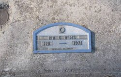
Ira Gene Arms
| Birth | : | 14 Nov 1914 Lewistown, Fergus County, Montana, USA |
| Death | : | 10 Feb 1972 Great Falls, Cascade County, Montana, USA |
| Burial | : | Bean Cemetery, Little River, Rice County, USA |
| Coordinate | : | 38.4061012, -97.9972000 |
| Plot | : | Section 3-A |
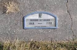
| Description | : | Marker shows death date as 1-72 Montana Death index shows death date as 2-10-72 .......... Great Falls Tribune Feb 11, 1972 Ira G. Arms, 57, Dies; Rites Pending Ira Gene Aarms, died Thursday in a local hospital. A former plasterer, he had been in ill health several years. Survivors include hi mother, Mrs. Bessie Arms, Great Falls, and a brother and sister living in other states. |
frequently asked questions (FAQ):
-
Where is Ira Gene Arms's memorial?
Ira Gene Arms's memorial is located at: Bean Cemetery, Little River, Rice County, USA.
-
When did Ira Gene Arms death?
Ira Gene Arms death on 10 Feb 1972 in Great Falls, Cascade County, Montana, USA
-
Where are the coordinates of the Ira Gene Arms's memorial?
Latitude: 38.4061012
Longitude: -97.9972000
Family Members:
Parent
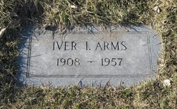
Siblings
Flowers:
Nearby Cemetories:
1. Bean Cemetery
Little River, Rice County, USA
Coordinate: 38.4061012, -97.9972000
2. Union Cemetery
Little River, Rice County, USA
Coordinate: 38.3260650, -97.9615720
3. Forest Home Cemetery
Rice County, USA
Coordinate: 38.5066986, -98.0171967
4. Lodiana Cemetery
Lyons, Rice County, USA
Coordinate: 38.3177986, -98.0627975
5. Windom Cemetery
Windom, McPherson County, USA
Coordinate: 38.3842010, -97.8694000
6. Andover Lutheran Cemetery
Windom, McPherson County, USA
Coordinate: 38.3013992, -97.9068985
7. Old Dunkard Cemetery
Rice County, USA
Coordinate: 38.3549200, -98.1455480
8. Excelsior Cemetery
Marquette, McPherson County, USA
Coordinate: 38.4639015, -97.8522034
9. Click Cemetery
Galt, Rice County, USA
Coordinate: 38.5186800, -98.0871200
10. Liscum Cemetery
Geneseo, Rice County, USA
Coordinate: 38.5144005, -98.1082993
11. Langley Cemetery
Langley, Ellsworth County, USA
Coordinate: 38.5508003, -97.9646988
12. Fairview Cemetery
McPherson County, USA
Coordinate: 38.4389000, -97.8058014
13. Monitor Church of the Brethren Cemetery
McPherson, McPherson County, USA
Coordinate: 38.3334750, -97.8141640
14. West Liberty Cemetery
Inman, McPherson County, USA
Coordinate: 38.2897290, -97.8520960
15. Lyons Municipal Cemetery
Lyons, Rice County, USA
Coordinate: 38.3589940, -98.2020190
16. Geneseo Cemetery
Geneseo, Rice County, USA
Coordinate: 38.5069008, -98.1680984
17. Un-Named Cemetery
Lyons, Rice County, USA
Coordinate: 38.3478140, -98.2110390
18. Amish Cemetery
McPherson County, USA
Coordinate: 38.2750015, -97.8416977
19. Groveland Cemetery
McPherson County, USA
Coordinate: 38.3182983, -97.7869034
20. Shumway Cemetery
Lyons, Rice County, USA
Coordinate: 38.3911018, -98.2356033
21. Elim Lutheran Cemetery
Marquette, McPherson County, USA
Coordinate: 38.5586930, -97.8426660
22. Rice County Poor Farm Cemetery
Rice County, USA
Coordinate: 38.3449410, -98.2387280
23. Marquette Cemetery
Marquette, McPherson County, USA
Coordinate: 38.5667000, -97.8360977
24. Zion Mennonite Cemetery
Inman, McPherson County, USA
Coordinate: 38.2596140, -97.8115820


