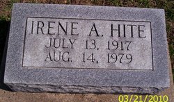
Irene Aletha Teeter Hite
| Birth | : | 13 Jul 1917 Glasgow, Jefferson County, Iowa, USA |
| Death | : | 15 Aug 1979 Keosauqua, Van Buren County, Iowa, USA |
| Burial | : | Badenscallie Burial Ground, Scotland |
| Coordinate | : | 58.0009120, -5.3239274 |
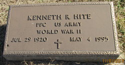
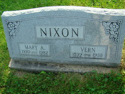
| Description | : | Mrs. Kenneth (Irene Aletha) Hite, 62, Farmington, died unexpectedlyn today, August 15, 1979 in the Van Buren county Memorial Hospital, Keosauqua. She was born July 13, 1917 at Glasgow, Iowa. She and Kenneth R. Hite were married June 28, 1968 at Kahoka, MO. Surviving are her husband; a brother, Frank Peeter of Rock Island, Ill; and a sister, Mrs. Vern (Anna) Nixon of Fairfield. She was preceded in death by a sister. Her parents were Clifford and Gertrude Giberson Peeter. The body is at the Hofbauer Funeral Home in Farmington where final rites will be at 1:30 p.m. Friday. The Rev. Michael R.... Read More |
frequently asked questions (FAQ):
-
Where is Irene Aletha Teeter Hite's memorial?
Irene Aletha Teeter Hite's memorial is located at: Badenscallie Burial Ground, Scotland.
-
When did Irene Aletha Teeter Hite death?
Irene Aletha Teeter Hite death on 15 Aug 1979 in Keosauqua, Van Buren County, Iowa, USA
-
Where are the coordinates of the Irene Aletha Teeter Hite's memorial?
Latitude: 58.0009120
Longitude: -5.3239274
Family Members:
Parent
Spouse
Siblings
Flowers:
Nearby Cemetories:
1. Badenscallie Burial Ground
Scotland
Coordinate: 58.0009120, -5.3239274
2. Clachan Burial Ground
Scotland
Coordinate: 57.8154408, -5.0705418
3. Cullicudden Old Churchyard
Scotland
Coordinate: 57.6550560, -4.2646760
4. Darnaway Castle
Scotland
Coordinate: 57.5745420, -3.6826550
5. Edinkillie New Cemetery
Scotland
Coordinate: 57.4993360, -3.6395210
6. Edinkillie Parish Churchyard
Scotland
Coordinate: 57.4991200, -3.6367100
7. Dunn Old Chapelyard
Scotland
Coordinate: 58.4850700, -3.3700400
8. Inverallan Cemetery
Scotland
Coordinate: 57.3140831, -3.6173489
9. Innes House Burial Ground
Scotland
Coordinate: 57.6687600, -3.1940000
10. Dipple Cemetery
Scotland
Coordinate: 57.6061820, -3.1257820
11. St Peters Kirkyard
Sandwick, Comox Valley Regional District, Canada
Coordinate: 59.0608361, -3.3441526
12. Harray Parish Kirkyard
Scotland
Coordinate: 59.0426286, -3.1976435
13. Invervar Graveyard Cladh Chunna's
Scotland
Coordinate: 56.6216000, -3.8671000
14. Rendall Old Kirkyard
Scotland
Coordinate: 59.0607864, -3.0049804
15. Shore Road
Scotland
Coordinate: 59.1181660, -3.0995341
16. St. Kilda Cemetery
Scotland
Coordinate: 57.8132320, -8.5708220
17. Strowan Churchyard
Scotland
Coordinate: 56.3684770, -3.9114120
18. Moneydie Parish Churchyard
Scotland
Coordinate: 56.4494600, -3.5165800
19. Menmuir Cemetery
Scotland
Coordinate: 56.7683780, -2.7638750
20. Redgorton Parish Churchyard
Scotland
Coordinate: 56.4385500, -3.4876000
21. Killevin Cemetery
Scotland
Coordinate: 56.1247200, -5.2412400
22. Kilaven Cemetery
Scotland
Coordinate: 56.1247000, -5.2413000
23. Achnabreac Cemetery
Scotland
Coordinate: 56.0920070, -5.4392620
24. St Fittick Kirkyard
Scotland
Coordinate: 57.1354400, -2.0627600


