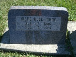
Irene Amber Nibel Mann
| Birth | : | 17 Feb 1886 Gowrie, Webster County, Iowa, USA |
| Death | : | 15 Aug 1964 Eldora, Hardin County, Iowa, USA |
| Burial | : | Calvary Cemetery, Winchendon, Worcester County, USA |
| Coordinate | : | 42.6805992, -72.0318985 |
| Plot | : | Block 0, Lot 69 |
| Description | : | "Eldora Herald-Ledger" Tues. Aug 18, 1964. Front page. "Rites Tuesday For Mrs. Irene Mann" Funeral services will be held Tuesday at 2 p.m. at the Longenecker Funeral Home for Mrs. Irene Mann, 78, of Steamboat Rock who passed away Saturday at the Eldora Memorial Hospital. The Rev. Walter Dimmlich, pastor of the Eldora Methodist Church, will officiate. Burial will be in the Eldora Cemetery. Pallbearers will be Magnus Chelstad, Johnnie Ganiff, Clifford Johnson, Kenneth Hilton, Larry Mumper and Roy Mumper. Mrs. Bert Ibach and Mrs. T. H. McEvoy will be in charge of... Read More |
frequently asked questions (FAQ):
-
Where is Irene Amber Nibel Mann's memorial?
Irene Amber Nibel Mann's memorial is located at: Calvary Cemetery, Winchendon, Worcester County, USA.
-
When did Irene Amber Nibel Mann death?
Irene Amber Nibel Mann death on 15 Aug 1964 in Eldora, Hardin County, Iowa, USA
-
Where are the coordinates of the Irene Amber Nibel Mann's memorial?
Latitude: 42.6805992
Longitude: -72.0318985
Family Members:
Parent
Spouse
Siblings
Flowers:
Nearby Cemetories:
1. Riverside Cemetery
Winchendon, Worcester County, USA
Coordinate: 42.6805992, -72.0263977
2. Massachusetts Veterans Memorial Cemetery
Winchendon, Worcester County, USA
Coordinate: 42.6851300, -72.0185200
3. Old Centre Burial Ground
Winchendon, Worcester County, USA
Coordinate: 42.6617012, -72.0366974
4. Robbins Cemetery
Rindge, Cheshire County, USA
Coordinate: 42.7266670, -72.0638890
5. Robbins Burial Ground
Rindge, Cheshire County, USA
Coordinate: 42.7268982, -72.0658035
6. Rand Cemetery
Rindge, Cheshire County, USA
Coordinate: 42.7350006, -72.0582962
7. New Boston Cemetery
Winchendon, Worcester County, USA
Coordinate: 42.6306000, -72.0860977
8. Hillside Cemetery
Rindge, Cheshire County, USA
Coordinate: 42.7463000, -72.0063900
9. Meeting House Cemetery
Rindge, Cheshire County, USA
Coordinate: 42.7501200, -72.0096700
10. Wood Family Cemetery
Rindge, Cheshire County, USA
Coordinate: 42.7457040, -71.9859410
11. Greenlawn Cemetery
Templeton, Worcester County, USA
Coordinate: 42.6124992, -72.0708008
12. Saint Josephs Cemetery
Gardner, Worcester County, USA
Coordinate: 42.5922012, -72.0391998
13. Wilder Cemetery
Rindge, Cheshire County, USA
Coordinate: 42.7395400, -71.9404900
14. Wildwood Cemetery
Gardner, Worcester County, USA
Coordinate: 42.5896988, -72.0306015
15. Fairbanks Cemetery
Ashburnham, Worcester County, USA
Coordinate: 42.6355220, -71.9236710
16. Meetinghouse Hill Cemetery
Ashburnham, Worcester County, USA
Coordinate: 42.6436900, -71.9176100
17. Saint Johns Cemetery
Gardner, Worcester County, USA
Coordinate: 42.5875015, -72.0207977
18. Notre Dame Cemetery
Gardner, Worcester County, USA
Coordinate: 42.5849991, -72.0222015
19. Riverside Cemetery
Royalston, Worcester County, USA
Coordinate: 42.6302986, -72.1453018
20. Jonas Alliene Cemetery
Royalston, Worcester County, USA
Coordinate: 42.6748790, -72.1656520
21. Cathedral of the Pines Cemetery
Rindge, Cheshire County, USA
Coordinate: 42.7749900, -71.9901800
22. New Cemetery
Ashburnham, Worcester County, USA
Coordinate: 42.6318400, -71.9137400
23. Crystal Lake Cemetery
Gardner, Worcester County, USA
Coordinate: 42.5833015, -71.9957962
24. Lawrence Brook Cemetery
Royalston, Worcester County, USA
Coordinate: 42.6693993, -72.1707993

