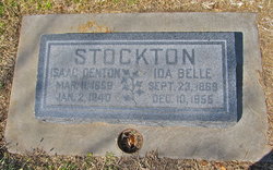
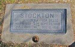
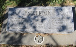
Isaac Denton Stockton
| Birth | : | 11 Mar 1859 Sonoma County, California, USA |
| Death | : | 2 Jan 1940 Willows, Glenn County, California, USA |
| Burial | : | Evergreen Cemetery, Ontario, Malheur County, USA |
| Coordinate | : | 44.0167007, -116.9757996 |
| Description | : | Isaac Denton Stockton (1859-1940) was a son of Dr. Isaac Denton Stockton (1815-1897) and Louisa Marion (nee Spiller) Stockton. Isaac Denton Stockton (1859-1940) married Ida Bell Duncan. - - - - - Although Isaac Denton Stockton (1859-1940) was a son of Dr. Isaac Denton Stockton (1815-1897) it does not appear that he went by Junior. The stone for Isaac Denton Stockton (1889-1918) shows him as I. Denton Stockton Jr. - - - - - 1900 Census, Ventura County, CA Isaac Stocton, b. Mar 1859 Ida B Stocton, b. Sep 1870 children: Nellie Stocton, b. Apr 1887 Isaac D Stocton, b. Sep 1889 Robert E Stocton, b. Jun 1893 Louis M... Read More |
frequently asked questions (FAQ):
-
Where is Isaac Denton Stockton's memorial?
Isaac Denton Stockton's memorial is located at: Evergreen Cemetery, Ontario, Malheur County, USA.
-
When did Isaac Denton Stockton death?
Isaac Denton Stockton death on 2 Jan 1940 in Willows, Glenn County, California, USA
-
Where are the coordinates of the Isaac Denton Stockton's memorial?
Latitude: 44.0167007
Longitude: -116.9757996
Family Members:
Parent
Spouse
Siblings
Children
Flowers:
Nearby Cemetories:
1. Evergreen Cemetery
Ontario, Malheur County, USA
Coordinate: 44.0167007, -116.9757996
2. Sunset Cemetery
Ontario, Malheur County, USA
Coordinate: 44.0225080, -116.9887300
3. Corpus Christi Catholic Church Columbarium
Fruitland, Payette County, USA
Coordinate: 44.0170500, -116.9281260
4. Washoe Cemetery
Payette County, USA
Coordinate: 44.0503006, -116.9471970
5. Beckmon Burial
Payette County, USA
Coordinate: 44.0565928, -116.9159265
6. Riverside Cemetery
Payette, Payette County, USA
Coordinate: 44.0952988, -116.9349976
7. Rosedale Memorial Gardens
Payette, Payette County, USA
Coordinate: 44.0902820, -116.9116120
8. Park View Cemetery
New Plymouth, Payette County, USA
Coordinate: 43.9761009, -116.8424988
9. Applegate Cemetery
Malheur County, USA
Coordinate: 44.1266600, -116.9298100
10. Applegate-Kennedy Cemetery
New Plymouth, Payette County, USA
Coordinate: 43.9749985, -116.7908020
11. Hilltop Memorial Cemetery
Nyssa, Malheur County, USA
Coordinate: 43.8834010, -117.0481340
12. Pioneer Cemetery
Vale, Malheur County, USA
Coordinate: 43.9994011, -117.2397003
13. Henderson Grave
Vale, Malheur County, USA
Coordinate: 43.9725500, -117.2359000
14. Valley View Cemetery
Vale, Malheur County, USA
Coordinate: 43.9972000, -117.2435989
15. Falk Cemetery
Payette County, USA
Coordinate: 43.9227982, -116.7343979
16. Fairview Cemetery
Ontario, Malheur County, USA
Coordinate: 44.2181015, -116.9847031
17. Parma Cemetery
Parma, Canyon County, USA
Coordinate: 43.7919006, -116.9511032
18. Owyhee River Cemetery
Owyhee, Malheur County, USA
Coordinate: 43.7956800, -117.0516300
19. Galloway Cemetery
Weiser, Washington County, USA
Coordinate: 44.2372017, -116.8869019
20. Owyhee Cemetery
Nyssa, Malheur County, USA
Coordinate: 43.7957993, -117.0847015
21. Hillcrest Cemetery
Weiser, Washington County, USA
Coordinate: 44.2585983, -116.9638290
22. Owyhee Pioneer Cemetery
Owyhee, Malheur County, USA
Coordinate: 43.7762500, -117.0787700
23. Lower Boise Cemetery
Parma, Canyon County, USA
Coordinate: 43.7599983, -116.8833008
24. Roswell Cemetery
Roswell, Canyon County, USA
Coordinate: 43.7435989, -116.9702988

