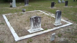
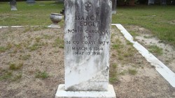
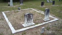
Isaac Lee Edge
| Birth | : | 6 Mar 1864 Horry County, South Carolina, USA |
| Death | : | 13 May 1951 Hope Mills, Cumberland County, North Carolina, USA |
| Burial | : | Salem Mennonite Church Cemetery, Turner County, USA |
| Coordinate | : | 43.3141890, -97.3364110 |
| Inscription | : | NORTH CAROLINA PVT 38 CO. COAST ARTY |
| Description | : | North Carolina PVT 38 Co. Coast Arty Name: Isaac L. Edge Residence: Dogwood Neck, Horry, South Carolina Birthdate: 1864 Birthplace: South Carolina, United States Relationship to head-of-household: Son Spouse's name: Spouse birthplace: Father's name: W. S. Edge Father's birthplace: South Carolina, United States Mother's name: Mother's birthplace: South Carolina, United States Race or color (expanded): White Ethnicity: American Gender: Male Marital status: Single Age: 16 years Occupation: At Home NARA film number: T9-1231 Page: 267 Page: D Entry number: 1025 Film number: 1255231 Collection: 1880 United States Census |
frequently asked questions (FAQ):
-
Where is Isaac Lee Edge's memorial?
Isaac Lee Edge's memorial is located at: Salem Mennonite Church Cemetery, Turner County, USA.
-
When did Isaac Lee Edge death?
Isaac Lee Edge death on 13 May 1951 in Hope Mills, Cumberland County, North Carolina, USA
-
Where are the coordinates of the Isaac Lee Edge's memorial?
Latitude: 43.3141890
Longitude: -97.3364110
Family Members:
Spouse
Flowers:

family through mariage to a Faulk
Left by Anonymous on 30 Nov 2008
family
Left by Anonymous on 23 Apr 2011
remembered
Left by Anonymous on 07 Feb 2013
Family
Left by Anonymous on 25 Jul 2018
Rest In Peace And God Bless.
Left by Anonymous on 08 Dec 2018

Thank you for your service to the USA. "For as in Adam all die, even so in Christ all shall be made Alive"
Left by Anonymous on 18 Nov 2021
Nearby Cemetories:
1. Salem Mennonite Church Cemetery
Turner County, USA
Coordinate: 43.3141890, -97.3364110
2. Salem Zion Mennonite Cemetery
Turner County, USA
Coordinate: 43.3507996, -97.3296967
3. Unruh Family Cemetery
Turner County, USA
Coordinate: 43.2801000, -97.3019500
4. West Side Cemetery
Turner County, USA
Coordinate: 43.2849998, -97.2891998
5. Turkey Valley Cemetery
Parker, Turner County, USA
Coordinate: 43.3280600, -97.2505500
6. Salem Community Cemetery
Turner County, USA
Coordinate: 43.2433500, -97.3995200
7. Saint Boniface Cemetery
Turkey Ridge, Turner County, USA
Coordinate: 43.2271100, -97.3189800
8. Freeman Cemetery
Freeman, Hutchinson County, USA
Coordinate: 43.3432999, -97.4589005
9. Tschetter Cemetery
Freeman, Hutchinson County, USA
Coordinate: 43.3866997, -97.4197006
10. Spring Valley Baptist Cemetery
Spring Valley, Turner County, USA
Coordinate: 43.2277000, -97.2694000
11. Zion Cemetery
Hurley, Turner County, USA
Coordinate: 43.2994003, -97.2003021
12. Bethany Cemetery
Hurley, Turner County, USA
Coordinate: 43.3003006, -97.1999969
13. Tieszen Cemetery
Marion, Turner County, USA
Coordinate: 43.4219017, -97.3388977
14. Buller-Ensz Cemetery
Turner County, USA
Coordinate: 43.4186000, -97.2828500
15. Bang Cemetery
Turner County, USA
Coordinate: 43.1997500, -97.3392000
16. Greenwood Cemetery
Marion, Turner County, USA
Coordinate: 43.4150009, -97.2493973
17. Huber Cemetery #3
Hutchinson County, USA
Coordinate: 43.2958080, -97.5061890
18. Hutterthal Mennonite Church Cemetery
Freeman, Hutchinson County, USA
Coordinate: 43.4041400, -97.4605000
19. Knodel Cemetery
Hutchinson County, USA
Coordinate: 43.2574997, -97.4938965
20. Spring Valley Lutheran Cemetery
Spring Valley, Turner County, USA
Coordinate: 43.1985500, -97.2605000
21. Anna Koerner Burial Site
Hutchinson County, USA
Coordinate: 43.4290258, -97.4196065
22. Carlson Cemetery
Turner County, USA
Coordinate: 43.1843987, -97.3174973
23. Huber Cemetery #2
Hutchinson County, USA
Coordinate: 43.3129700, -97.5165800
24. Saint Marys Catholic Cemetery
Marion, Turner County, USA
Coordinate: 43.4371986, -97.2596970


