
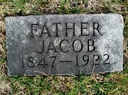
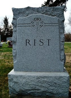
Jacob Rist
| Birth | : | 29 Apr 1847 |
| Death | : | 3 May 1922 |
| Burial | : | Oakdale Cemetery, Bluford, Jefferson County, USA |
| Coordinate | : | 38.3801400, -88.7426600 |
| Plot | : | W 49- 3 |
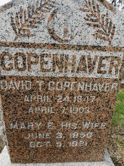
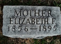
| Description | : | Son of Peter Rist & Sarah Johnson Rist. Married to Elizabeth Harrick . Remarried to Mary Elizabeth (Etnire) Copenhaver on Apr. 8, 1909 in Pawnee City, Nebraska. (Pawnee Library, book of obits in the Pawnee Republican.) |
frequently asked questions (FAQ):
-
Where is Jacob Rist's memorial?
Jacob Rist's memorial is located at: Oakdale Cemetery, Bluford, Jefferson County, USA.
-
When did Jacob Rist death?
Jacob Rist death on 3 May 1922 in
-
Where are the coordinates of the Jacob Rist's memorial?
Latitude: 38.3801400
Longitude: -88.7426600
Family Members:
Parent
Spouse
Siblings
Flowers:


Nearby Cemetories:
1. Oakdale Cemetery
Bluford, Jefferson County, USA
Coordinate: 38.3801400, -88.7426600
2. Buffington-French Cemetery
Harmony, Jefferson County, USA
Coordinate: 38.3871500, -88.7426230
3. Mount Zion Cemetery
Bluford, Jefferson County, USA
Coordinate: 38.4085320, -88.7251780
4. Mifflin Cemetery
Jefferson County, USA
Coordinate: 38.3958015, -88.6996994
5. East Hickory Hill Cemetery
Bluford, Jefferson County, USA
Coordinate: 38.3431700, -88.7606900
6. Clark Cemetery
Camp Ground, Jefferson County, USA
Coordinate: 38.3760986, -88.7960968
7. Harmony Cemetery
Harmony, Jefferson County, USA
Coordinate: 38.4083500, -88.7929300
8. Zion Cemetery
Keenesville, Wayne County, USA
Coordinate: 38.4015100, -88.6845900
9. Newton Cemetery
Camp Ground, Jefferson County, USA
Coordinate: 38.3391991, -88.7996979
10. Egbert Cemetery
Keenes, Wayne County, USA
Coordinate: 38.3428001, -88.6808014
11. Wood Cemetery
Keenes, Wayne County, USA
Coordinate: 38.3555984, -88.6707993
12. Greenwalt Cemetery
Stratton, Jefferson County, USA
Coordinate: 38.4418983, -88.7189026
13. Atkinson Cemetery
Camp Ground, Jefferson County, USA
Coordinate: 38.3574982, -88.8202972
14. Black Oak Ridge Cemetery
Bluford, Jefferson County, USA
Coordinate: 38.3171997, -88.7711029
15. Fally Cemetery
Stratton, Jefferson County, USA
Coordinate: 38.4453011, -88.7621994
16. Crask Cemetery
Wayne County, USA
Coordinate: 38.4178009, -88.6652985
17. Tyler Cemetery
Wayne County, USA
Coordinate: 38.4033012, -88.6560974
18. Ricker Farm Cemetery
Harmony, Jefferson County, USA
Coordinate: 38.4490000, -88.7743000
19. Garrison Temple Cemetery
Wayne County, USA
Coordinate: 38.4420800, -88.6882200
20. Dobbs Cemetery
Wayne County, USA
Coordinate: 38.4317017, -88.6714020
21. New Home Cemetery
Stratton, Jefferson County, USA
Coordinate: 38.4571300, -88.7127500
22. Wells Chapel Cemetery
Shields, Jefferson County, USA
Coordinate: 38.4608300, -88.7469600
23. Atteberry Cemetery
Keenesville, Wayne County, USA
Coordinate: 38.4083700, -88.6451200
24. East Salem Cemetery
Jefferson County, USA
Coordinate: 38.3706044, -88.8467283