
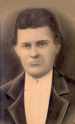
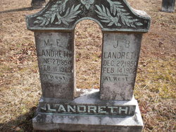
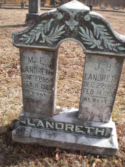
James Basil Landreth
| Birth | : | 27 Dec 1850 Humphreys County, Tennessee, USA |
| Death | : | 14 Feb 1902 Stoddard County, Missouri, USA |
| Burial | : | Clifton Cemetery, Clifton, Oregon County, USA |
| Coordinate | : | 36.5511017, -91.5350037 |
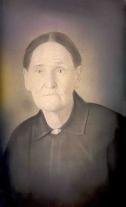
| Description | : | Son of William M. Landreth and Mary Jane Cuff Married Martha Ellen Chandler on 23 Mar 1873 in Oregon Co., Missouri Father of William N., Mary J., Lewis, Lottie, James Patrick, Mike Paris, Cora, Frank M. Hallie M., Minnie, Winnie and Bessie F. Landreth Farmer |
frequently asked questions (FAQ):
-
Where is James Basil Landreth's memorial?
James Basil Landreth's memorial is located at: Clifton Cemetery, Clifton, Oregon County, USA.
-
When did James Basil Landreth death?
James Basil Landreth death on 14 Feb 1902 in Stoddard County, Missouri, USA
-
Where are the coordinates of the James Basil Landreth's memorial?
Latitude: 36.5511017
Longitude: -91.5350037
Family Members:
Flowers:


Nearby Cemetories:
1. Clifton Cemetery
Clifton, Oregon County, USA
Coordinate: 36.5511017, -91.5350037
2. Old George Martin Farm Cemetery
Allen Ford, Oregon County, USA
Coordinate: 36.5374850, -91.5230010
3. Clifton Cemetery
Sloan Ford, Oregon County, USA
Coordinate: 36.5677900, -91.5329000
4. Bledsaw Cemetery
Thayer, Oregon County, USA
Coordinate: 36.5595741, -91.5537949
5. N B Allen Ford
Allen Ford, Oregon County, USA
Coordinate: 36.5411700, -91.5172900
6. Brenner Farm Cemetery
Allen Ford, Oregon County, USA
Coordinate: 36.5477000, -91.5065400
7. Ragan Cemetery
Thayer, Oregon County, USA
Coordinate: 36.5235863, -91.5213242
8. Roth Cemetery
Sloan Ford, Oregon County, USA
Coordinate: 36.5808945, -91.5498657
9. Two Mile Cemetery
Thayer, Oregon County, USA
Coordinate: 36.5485700, -91.5748800
10. Dode Jones Farm Cemetery
Sloan Ford, Oregon County, USA
Coordinate: 36.5804900, -91.5568800
11. Willard Dode Jones Farm Cemetery
Thayer, Oregon County, USA
Coordinate: 36.5808300, -91.5572300
12. Sergeant-Mount Olive Cemetery
Thayer, Oregon County, USA
Coordinate: 36.5634390, -91.5755830
13. Thayer Cemetery
Thayer, Oregon County, USA
Coordinate: 36.5152200, -91.5395100
14. Crazy Spring
Thayer, Oregon County, USA
Coordinate: 36.5818700, -91.5624100
15. Lindley Cemetery
Clifton, Oregon County, USA
Coordinate: 36.5820400, -91.5036200
16. Buehler Farm Cemetery
Clifton, Oregon County, USA
Coordinate: 36.5639496, -91.4845810
17. Warren Coats Farm Cemetery
Sloan Ford, Oregon County, USA
Coordinate: 36.5986700, -91.5438800
18. Davis Cemetery
Thayer, Oregon County, USA
Coordinate: 36.5339508, -91.4751358
19. Old Town Church of God
Old Town, Oregon County, USA
Coordinate: 36.5004900, -91.5451800
20. Spring City Cemetery
Mammoth Spring, Fulton County, USA
Coordinate: 36.4983360, -91.5308040
21. Spring City Cemetery #2
Mammoth Spring, Fulton County, USA
Coordinate: 36.4982800, -91.5299400
22. Union Hill Cemetery
Brandsville, Howell County, USA
Coordinate: 36.5256341, -91.4746829
23. Jeff Cemetery
Jeff, Oregon County, USA
Coordinate: 36.5256166, -91.4746129
24. Walker Cemetery
Thayer, Oregon County, USA
Coordinate: 36.5985985, -91.5697021