
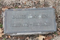
James Dryden
| Birth | : | 27 Feb 1863 North Dumfries Township, Waterloo Regional Municipality, Ontario, Canada |
| Death | : | 5 Feb 1935 Modesto, Stanislaus County, California, USA |
| Burial | : | Modesto Pioneer Cemetery, Modesto, Stanislaus County, USA |
| Coordinate | : | 37.6473350, -120.9829040 |
| Plot | : | Section A Tier 13 Grave 42 |
| Description | : | James Dryden is the only poultryman in the National Agricultural Hall of Fame. While a professor at Oregon Agricultural College, now Oregon State University, he bred Lady McDuff, the first hen ever documented to lay more than 300 eggs per year as well as Oregona, the first hen proved to have laid more than 1,000 eggs during a laying career. Professor Dryden probably did more to make affordable instead of rare luxury items than any individual in the history of agriculture. You can look him up on the National Agricultural Hall of Fame webpage. |
frequently asked questions (FAQ):
-
Where is James Dryden's memorial?
James Dryden's memorial is located at: Modesto Pioneer Cemetery, Modesto, Stanislaus County, USA.
-
When did James Dryden death?
James Dryden death on 5 Feb 1935 in Modesto, Stanislaus County, California, USA
-
Where are the coordinates of the James Dryden's memorial?
Latitude: 37.6473350
Longitude: -120.9829040
Family Members:
Parent
Spouse
Siblings

Flowers:


Nearby Cemetories:
1. Modesto Pioneer Cemetery
Modesto, Stanislaus County, USA
Coordinate: 37.6473350, -120.9829040
2. Acacia Memorial Park
Modesto, Stanislaus County, USA
Coordinate: 37.6481080, -120.9836610
3. Modesto Citizens Cemetery
Modesto, Stanislaus County, USA
Coordinate: 37.6472930, -120.9845570
4. Saint Stanislaus Catholic Cemetery
Modesto, Stanislaus County, USA
Coordinate: 37.6473610, -120.9808440
5. Modesto County Cemetery
Modesto, Stanislaus County, USA
Coordinate: 37.6492400, -120.9813800
6. Ceres Memorial Park
Ceres, Stanislaus County, USA
Coordinate: 37.5958214, -120.9634399
7. Lakewood Memorial Park
Hughson, Stanislaus County, USA
Coordinate: 37.6199760, -120.8975983
8. Good Shepherd Catholic Cemetery
Modesto, Stanislaus County, USA
Coordinate: 37.6853130, -121.0672890
9. Wood Colony Cemetery
Salida, Stanislaus County, USA
Coordinate: 37.6893730, -121.0682144
10. Burwood Cemetery
Escalon, San Joaquin County, USA
Coordinate: 37.7616997, -120.9593964
11. Langworth Cemetery
Oakdale, Stanislaus County, USA
Coordinate: 37.7580986, -120.8957977
12. Ripon Cemetery
Ripon, San Joaquin County, USA
Coordinate: 37.7420311, -121.1238708
13. Oakdale Citizens Cemetery
Oakdale, Stanislaus County, USA
Coordinate: 37.7624600, -120.8388800
14. Oaklawn Memorial Park
Oakdale, Stanislaus County, USA
Coordinate: 37.7711945, -120.8486862
15. Saint John's Catholic Cemetery
Escalon, San Joaquin County, USA
Coordinate: 37.7994537, -121.0705185
16. Denair Cemetery
Denair, Stanislaus County, USA
Coordinate: 37.5293999, -120.8199997
17. Martin Cemetery
Waterford, Stanislaus County, USA
Coordinate: 37.6684360, -120.7582160
18. Turlock Memorial Park
Turlock, Stanislaus County, USA
Coordinate: 37.4937592, -120.8659821
19. Grayson Cemetery
Grayson, Stanislaus County, USA
Coordinate: 37.5594559, -121.1802826
20. Valley Home Memorial Park
Oakdale, Stanislaus County, USA
Coordinate: 37.8275528, -120.9333267
21. Saint Francis Episcopal Church Columbarium
Turlock, Stanislaus County, USA
Coordinate: 37.5014300, -120.8368400
22. Patterson District Cemetery
Patterson, Stanislaus County, USA
Coordinate: 37.5268135, -121.1728287
23. Atlanta Cemetery
Five Corners, San Joaquin County, USA
Coordinate: 37.8270035, -121.1420135
24. North Hilmar Cemetery
Hilmar, Merced County, USA
Coordinate: 37.4146614, -120.8864288