James E. “Jim” Cook
| Birth | : | 6 Jun 1952 Odell, Gage County, Nebraska, USA |
| Death | : | 22 Nov 2020 Beatrice, Gage County, Nebraska, USA |
| Burial | : | Liberty Cemetery, Liberty, Gage County, USA |
| Coordinate | : | 40.0772018, -96.4982986 |
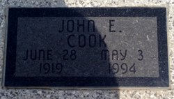
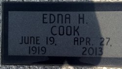
| Description | : | James E. “Jim” Cook, 68 of Barneston passed away Sunday, November 22, 2020 at Beatrice Health & Rehab. Jim was born on June 6, 1952 in Odell, NE to John E. and Edna (Horsky) Cook. He was married to his high school sweetheart, Cathy J. (Clark) Cook for 48 years. He attended Sunnyside, a one-room country school and graduated from Barneston High School in 1970. Jim enjoyed reading and watching westerns, football, playing pool and cards, gardening (growing very hot peppers) music and dancing and of course, fishing. Jim worked for the Union Pacific Railroad for 40 years as a... Read More |
frequently asked questions (FAQ):
-
Where is James E. “Jim” Cook's memorial?
James E. “Jim” Cook's memorial is located at: Liberty Cemetery, Liberty, Gage County, USA.
-
When did James E. “Jim” Cook death?
James E. “Jim” Cook death on 22 Nov 2020 in Beatrice, Gage County, Nebraska, USA
-
Where are the coordinates of the James E. “Jim” Cook's memorial?
Latitude: 40.0772018
Longitude: -96.4982986
Family Members:
Parent
Flowers:
Nearby Cemetories:
1. Liberty Cemetery
Liberty, Gage County, USA
Coordinate: 40.0772018, -96.4982986
2. Kinney Cemetery
Gage County, USA
Coordinate: 40.1102100, -96.5588800
3. Barneston Cemetery
Barneston, Gage County, USA
Coordinate: 40.0661011, -96.5755997
4. Saint Josephs Cemetery
Barneston, Gage County, USA
Coordinate: 40.0653000, -96.5757980
5. Evangelical Lutheran Cemetery
Liberty, Gage County, USA
Coordinate: 40.0083300, -96.4825100
6. Pleasant Hill Cemetery
Gage County, USA
Coordinate: 40.1462250, -96.4676820
7. Mission Creek Cemetery
Pawnee County, USA
Coordinate: 40.0149994, -96.4263992
8. Tanner Cemetery
Pawnee County, USA
Coordinate: 40.0238991, -96.4143982
9. Mission Creek Cemetery
Marshall County, USA
Coordinate: 39.9866982, -96.4649963
10. Saint Johns Cemetery
Barneston, Gage County, USA
Coordinate: 40.0449982, -96.6380997
11. Bethel Cemetery
Wymore, Gage County, USA
Coordinate: 40.0588989, -96.6513977
12. Sacred Heart Cemetery
Burchard, Pawnee County, USA
Coordinate: 40.1460991, -96.3683014
13. Burchard Cemetery
Burchard, Pawnee County, USA
Coordinate: 40.1383018, -96.3538971
14. Mount Pleasant Cemetery
Burchard, Pawnee County, USA
Coordinate: 40.1822014, -96.4049988
15. North Elm Cemetery
Marshall County, USA
Coordinate: 39.9431000, -96.5325012
16. Richland Center Cemetery
Marshall County, USA
Coordinate: 39.9584000, -96.4073700
17. Oketo Cemetery
Oketo, Marshall County, USA
Coordinate: 39.9571991, -96.5950012
18. Virginia Cemetery
Virginia, Gage County, USA
Coordinate: 40.2186012, -96.5117035
19. Summerfield Cemetery
Summerfield, Marshall County, USA
Coordinate: 40.0005989, -96.3422012
20. Holy Family Cemetery
Summerfield, Marshall County, USA
Coordinate: 39.9994011, -96.3414001
21. Immanuel Lutheran Cemetery
Wymore, Gage County, USA
Coordinate: 40.0015830, -96.6573720
22. Blue Springs Cemetery
Blue Springs, Gage County, USA
Coordinate: 40.1526800, -96.6627000
23. Calvary Cemetery
Wymore, Gage County, USA
Coordinate: 40.1225014, -96.6917038
24. Wymore Cemetery
Wymore, Gage County, USA
Coordinate: 40.1241989, -96.6917038


