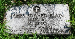
James Edward Blain
| Birth | : | 25 Jan 1925 Orrick, Ray County, Missouri, USA |
| Death | : | 21 Aug 1949 Jackson County, Missouri, USA |
| Burial | : | Calvary Cemetery, Hankinson, Richland County, USA |
| Coordinate | : | 46.0586014, -96.9100037 |
| Plot | : | Bottom/Sect.5 |
| Description | : | M1, Missouri, USNR |
frequently asked questions (FAQ):
-
Where is James Edward Blain's memorial?
James Edward Blain's memorial is located at: Calvary Cemetery, Hankinson, Richland County, USA.
-
When did James Edward Blain death?
James Edward Blain death on 21 Aug 1949 in Jackson County, Missouri, USA
-
Where are the coordinates of the James Edward Blain's memorial?
Latitude: 46.0586014
Longitude: -96.9100037
Family Members:
Parent
Flowers:
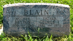
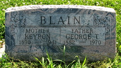
James Edward Blain, 24-year-old son of George T. and Keyron (Bailey) Blain, died as the result of an auto accident in Jackson County.
Left by Anonymous on 22 Dec 2013

Thank you for your service to our country.
Left by Anonymous on 13 Apr 2014

GOD bless and keep thee close to HIM. Thanks for your Naval service in WWII.
Left by Anonymous on 08 Jan 2021
Nearby Cemetories:
1. Calvary Cemetery
Hankinson, Richland County, USA
Coordinate: 46.0586014, -96.9100037
2. Hillside Cemetery
Hankinson, Richland County, USA
Coordinate: 46.0578003, -96.9100037
3. Saint Francis Convent Cemetery
Hankinson, Richland County, USA
Coordinate: 46.0625300, -96.9027100
4. United Cemetery
Hankinson, Richland County, USA
Coordinate: 46.0650139, -96.9093704
5. Coppin Cemetery
Hankinson, Richland County, USA
Coordinate: 46.0461006, -96.9460983
6. Immanuel Lutheran Cemetery
Hankinson, Richland County, USA
Coordinate: 46.0936012, -96.8869019
7. Saint Johns Cemetery
Richland County, USA
Coordinate: 46.1390620, -96.9167520
8. Trinity Cemetery
Great Bend, Richland County, USA
Coordinate: 46.1422005, -96.8039017
9. Tyson Cemetery
Richland County, USA
Coordinate: 45.9488983, -96.8664017
10. Zion United Methodist Cemetery
Great Bend, Richland County, USA
Coordinate: 46.1524600, -96.8028100
11. Calvary Cemetery
Mantador, Richland County, USA
Coordinate: 46.1678009, -96.9894028
12. Saint Josephs Cemetery
Richland County, USA
Coordinate: 46.1227989, -96.7433014
13. Immanuel Lutheran Cemetery
Lidgerwood, Richland County, USA
Coordinate: 46.0074100, -97.1163300
14. Bohemian Cemetery
Roberts County, USA
Coordinate: 45.9075012, -96.9458008
15. Saint Pauls Cemetery
Hammer, Roberts County, USA
Coordinate: 45.9211006, -97.0186005
16. Saint Nicholas Cemetery
Rosholt, Roberts County, USA
Coordinate: 45.9219000, -96.7986000
17. Pleasant View Cemetery
Lidgerwood, Richland County, USA
Coordinate: 46.0767500, -97.1361020
18. Thompson Cemetery
Roberts County, USA
Coordinate: 45.9068985, -96.9764023
19. Holy Cross Cemetery
Lidgerwood, Richland County, USA
Coordinate: 46.0759600, -97.1376420
20. Plains of Memory Cemetery
Roberts County, USA
Coordinate: 45.9066200, -96.9772100
21. Divet Farm Cemetery
Mooreton, Richland County, USA
Coordinate: 46.2181180, -96.8660410
22. Old Brandvold Cemetery
Roberts County, USA
Coordinate: 45.8932991, -96.8535995
23. Bohemian Cemetery
Lidgerwood, Richland County, USA
Coordinate: 46.0633011, -97.1556015
24. Saint Johns Cemetery
Lidgerwood, Richland County, USA
Coordinate: 46.0555992, -97.1564026


