
| Birth | : | 29 Oct 1918 Siskiyou County, California, USA |
| Death | : | 3 Jul 1998 Yolo, Yolo County, California, USA |
| Burial | : | Saint Marys Cemetery, Barnesville Township, Clay County, USA |
| Coordinate | : | 46.6542600, -96.4386300 |
| Plot | : | Northwest Section |
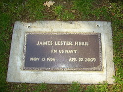
| Inscription | : | Twins Oct. 29, 1918 James Herr July 3, 1998 June Faraone Nov. 3, 2000 |
| Description | : | Shared marker. Twins -------------- James Edward Herr, 79, of Yolo, died July 3, 1998 after a long illness. James was born Oct. 29, 1918 near Ager to Ed and Mary Herr. He graduated from Yreka High School in 1935. James was a veteran of WWII. He worked as a Merchant Seaman for 20 years and also worked for Hunts Corp. in Woodland for 20 years. James loved gardening and dogs. Survivors include his twin sister, June Faraone of Yolo; two sons, Jim Herr of Yolo and Jack Herr of Greenview; a daughter, Judy Stocks of Yreka; four grandchildren; and six great-grandchildren.... Read More |
frequently asked questions (FAQ):
-
Where is James Edward Herr's memorial?
James Edward Herr's memorial is located at: Saint Marys Cemetery, Barnesville Township, Clay County, USA.
-
When did James Edward Herr death?
James Edward Herr death on 3 Jul 1998 in Yolo, Yolo County, California, USA
-
Where are the coordinates of the James Edward Herr's memorial?
Latitude: 46.6542600
Longitude: -96.4386300
Family Members:
Parent

Siblings
Children
Flowers:


Nearby Cemetories:
1. Saint Marys Cemetery
Barnesville Township, Clay County, USA
Coordinate: 46.6542600, -96.4386300
2. Barnesville City Cemetery
Barnesville, Clay County, USA
Coordinate: 46.6530800, -96.4401600
3. Rosemound Cemetery
Barnesville Township, Clay County, USA
Coordinate: 46.6536100, -96.4413900
4. Norwegian Cemetery
Humboldt Township, Clay County, USA
Coordinate: 46.6747017, -96.3899994
5. Elkton Cemetery
Elkton Township, Clay County, USA
Coordinate: 46.7344017, -96.4522018
6. Gran Lutheran Church Cemetery
Skree Township, Clay County, USA
Coordinate: 46.7179310, -96.3205290
7. Prairie View Cemetery
Wilkin County, USA
Coordinate: 46.5919991, -96.3020020
8. Little Bethany Church Cemetery
Norwegian Grove, Otter Tail County, USA
Coordinate: 46.6196660, -96.2806500
9. Zion Lutheran Cemetery
Skree Township, Clay County, USA
Coordinate: 46.7722015, -96.3656006
10. Aspelund Cemetery
Tansem Township, Clay County, USA
Coordinate: 46.6753006, -96.2367020
11. Deerhorn Cemetery
Wilkin County, USA
Coordinate: 46.5793991, -96.6119003
12. West North Immanuel Church Cemetery
Norwegian Grove, Otter Tail County, USA
Coordinate: 46.6166992, -96.2253036
13. North Immanuel Cemetery
Norwegian Grove, Otter Tail County, USA
Coordinate: 46.6093300, -96.2139600
14. Rollag Lutheran Cemetery
Rollag, Clay County, USA
Coordinate: 46.7401000, -96.2386200
15. Grong Cemetery
Rollag, Clay County, USA
Coordinate: 46.7434196, -96.2380142
16. Trinity Lutheran Cemetery
Elmwood Township, Clay County, USA
Coordinate: 46.7751080, -96.6229430
17. Elmwood Cemetery
Elmwood Township, Clay County, USA
Coordinate: 46.7867012, -96.6091995
18. Manston Cemetery
Wilkin County, USA
Coordinate: 46.4780998, -96.4655991
19. Christ Lutheran Cemetery
Wilkin County, USA
Coordinate: 46.4937200, -96.5485800
20. Yankee Cemetery
Parke Township, Clay County, USA
Coordinate: 46.7468080, -96.2163140
21. Bethany Cemetery
Parke Township, Clay County, USA
Coordinate: 46.7388889, -96.1958333
22. Silver Lake Pioneer Cemetery
Hawley Township, Clay County, USA
Coordinate: 46.8339005, -96.3503036
23. Norwegian Grove Cemetery
Norwegian Grove, Otter Tail County, USA
Coordinate: 46.5688900, -96.1824700
24. Wolverton Norwegian Lutheran Cemetery
Wolverton, Wilkin County, USA
Coordinate: 46.5872002, -96.7189026