
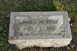
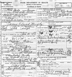
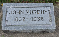
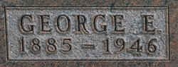
James Edward Murphy
| Birth | : | 26 Jun 1875 Manitowoc, Manitowoc County, Wisconsin, USA |
| Death | : | 30 Sep 1942 Rockwell, Cerro Gordo County, Iowa, USA |
| Burial | : | Saint Patricks Catholic Cemetery, Dougherty, Cerro Gordo County, USA |
| Coordinate | : | 42.9227791, -93.0294418 |
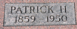
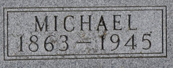
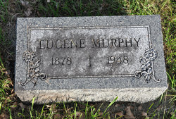
| Description | : | Globe Gazette Mason City, Iowa Thursday, 1 October 1942 JAMES MURPHY, DOUGHERTY, DIES Services to be held at St. Patrick's Church Saturday Dougherty - James Murphy, 57, a resident of this vicinity for 50 years, died Wednesday afternoon at 3:30 o'clock at the hospital in Rockwell after a lingering illness. Born in Manitowoc, Wis., he came here at an early age and lived on a farm four miles west and a mile north of Dougherty. Surviving are four brothers, Pat and Mike of Mason City, Gene and George of Dougherty, and three sisters, Mrs. Ed Donnelly... Read More |
frequently asked questions (FAQ):
-
Where is James Edward Murphy's memorial?
James Edward Murphy's memorial is located at: Saint Patricks Catholic Cemetery, Dougherty, Cerro Gordo County, USA.
-
When did James Edward Murphy death?
James Edward Murphy death on 30 Sep 1942 in Rockwell, Cerro Gordo County, Iowa, USA
-
Where are the coordinates of the James Edward Murphy's memorial?
Latitude: 42.9227791
Longitude: -93.0294418
Family Members:
Parent

Siblings
Flowers:


Nearby Cemetories:
1. Saint Patricks Catholic Cemetery
Dougherty, Cerro Gordo County, USA
Coordinate: 42.9227791, -93.0294418
2. West Fork Cemetery
Franklin County, USA
Coordinate: 42.8918991, -93.0836029
3. Saint John Zion Cemetery
Sheffield, Franklin County, USA
Coordinate: 42.8969002, -93.1472015
4. Halls Grove Cemetery
Greene, Butler County, USA
Coordinate: 42.8840100, -92.8782300
5. Westside Cemetery
Marble Rock, Floyd County, USA
Coordinate: 42.9556007, -92.8739014
6. Sacred Heart Cemetery
Rockwell, Cerro Gordo County, USA
Coordinate: 42.9592018, -93.1913986
7. Hillside Cemetery
Marble Rock, Floyd County, USA
Coordinate: 42.9583015, -92.8666992
8. Hillside Cemetery
Sheffield, Franklin County, USA
Coordinate: 42.9006004, -93.2007980
9. Rockwell Cemetery
Rockwell, Cerro Gordo County, USA
Coordinate: 42.9786000, -93.1919000
10. Needham Cemetery
Bristow, Butler County, USA
Coordinate: 42.7956500, -92.9726300
11. Riverside Cemetery
Rockford, Floyd County, USA
Coordinate: 43.0578003, -92.9464035
12. Harlan Cemetery
Dumont, Butler County, USA
Coordinate: 42.7663994, -93.0143967
13. Hansell Cemetery
Franklin County, USA
Coordinate: 42.7666702, -93.1047211
14. North Vilmar Cemetery
Vilmar, Butler County, USA
Coordinate: 42.8329700, -92.8392900
15. Oak Hill Cemetery
Bristow, Butler County, USA
Coordinate: 42.7719002, -92.9353027
16. Way Side Cemetery
Chapin, Franklin County, USA
Coordinate: 42.8293991, -93.2225037
17. Old Bristow Cemetery
Bristow, Butler County, USA
Coordinate: 42.7733078, -92.9165845
18. Owens Grove Cemetery
Cerro Gordo County, USA
Coordinate: 43.0825005, -93.1144180
19. Dumont Cemetery
Dumont, Butler County, USA
Coordinate: 42.7553177, -92.9748230
20. Rose Hill Cemetery
Greene, Butler County, USA
Coordinate: 42.8843994, -92.7988968
21. Flood Creek Cemetery
Floyd County, USA
Coordinate: 43.0391998, -92.8538971
22. Saint Marys Cemetery
Greene, Butler County, USA
Coordinate: 42.8827300, -92.7990200
23. Hardeman Cemetery
Greene, Butler County, USA
Coordinate: 42.8706017, -92.8013992
24. Shobes Grove Cemetery
Franklin County, USA
Coordinate: 42.9000015, -93.2722168