


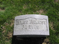


James Ernest Purvis
| Birth | : | 25 May 1853 Bremen, Fairfield County, Ohio, USA |
| Death | : | 28 Nov 1917 Greenville, Hunt County, Texas, USA |
| Burial | : | Matthew Chapel Cemetery, Coosa, Floyd County, USA |
| Coordinate | : | 34.2407990, -85.3088989 |
| Plot | : | B-21 |
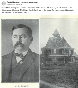
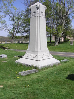
| Description | : | Bremen OIL KING DIES AT Greenville, Texas J.E. PURVIS FOUNDER OF BREMEN OHIO AND ONE OF THE MOST WIDELY KNOWN MEN IN THIS PART OF THE COUNTRY DIED SUDDENLY WHILE RETURNING FROM HOME Of BROTHER A telegram rceived in Bremen, Ohio early Thursday morning contained the startling news of the death of J.E. Purvis, one of the most widely known men in that vicinity; and known throughout Fairfield County as "The Bremen Oil King." Mr.... Read More |
frequently asked questions (FAQ):
-
Where is James Ernest Purvis's memorial?
James Ernest Purvis's memorial is located at: Matthew Chapel Cemetery, Coosa, Floyd County, USA.
-
When did James Ernest Purvis death?
James Ernest Purvis death on 28 Nov 1917 in Greenville, Hunt County, Texas, USA
-
Where are the coordinates of the James Ernest Purvis's memorial?
Latitude: 34.2407990
Longitude: -85.3088989
Family Members:
Parent

Spouse

Siblings
Children

Flowers:


Nearby Cemetories:
1. Matthew Chapel Cemetery
Coosa, Floyd County, USA
Coordinate: 34.2407990, -85.3088989
2. Mount Pleasant Cemetery
Coosa, Floyd County, USA
Coordinate: 34.2630997, -85.3150024
3. Pisgah Baptist Church Cemetery
Rome, Floyd County, USA
Coordinate: 34.2574997, -85.3422012
4. Mountain End Lake Cemetery
Floyd County, USA
Coordinate: 34.2160988, -85.2835999
5. Livingston Cemetery
Floyd County, USA
Coordinate: 34.2160988, -85.3499985
6. Butler Cemetery
Floyd County, USA
Coordinate: 34.2518997, -85.3621979
7. Bush Arbor Baptist Church Cemetery
Rome, Floyd County, USA
Coordinate: 34.1949997, -85.2822037
8. Beech Creek Cemetery
Rome, Floyd County, USA
Coordinate: 34.2714005, -85.2593994
9. Community Chapel Cemetery
Rome, Floyd County, USA
Coordinate: 34.1903000, -85.2966995
10. Oaknoll Memorial Gardens Cemetery
Rome, Floyd County, USA
Coordinate: 34.2708015, -85.2453003
11. Mount Alto Cemetery
Floyd County, USA
Coordinate: 34.2989006, -85.2882996
12. Transfiguration Episcopal Church Memory Garden
Rome, Floyd County, USA
Coordinate: 34.2653690, -85.2394440
13. Sardis Cemetery
Rome, Floyd County, USA
Coordinate: 34.2661018, -85.3783035
14. Mountain View Cemetery
Floyd County, USA
Coordinate: 34.1791992, -85.2763977
15. Fellowship Baptist Church Cemetery
Rome, Floyd County, USA
Coordinate: 34.2633018, -85.2264023
16. Macedonia Cemetery
Floyd County, USA
Coordinate: 34.2158012, -85.3918991
17. Cedar Creek Cemetery
Cave Spring, Floyd County, USA
Coordinate: 34.1685982, -85.3419037
18. Possum Trot Cemetery
Floyd County, USA
Coordinate: 34.3064003, -85.2542038
19. Free Liberty Cemetery
Floyd County, USA
Coordinate: 34.1660995, -85.2699966
20. Clemones Cemetery
Floyd County, USA
Coordinate: 34.2214012, -85.4111023
21. Vann Cemetery
Floyd County, USA
Coordinate: 34.2543983, -85.4156036
22. Mount Zion Cemetery
Floyd County, USA
Coordinate: 34.2578011, -85.4156036
23. Montgomery Cemetery
Floyd County, USA
Coordinate: 34.1535988, -85.2739029
24. Blacks Bluff Cemetery
Rome, Floyd County, USA
Coordinate: 34.2192900, -85.1995000