
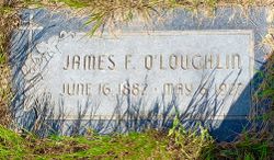
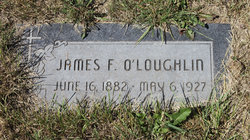
James Francis O'Loughlin
| Birth | : | 16 Jun 1882 Nemaha County, Kansas, USA |
| Death | : | 6 May 1927 Conrad, Pondera County, Montana, USA |
| Burial | : | Holy Angels Cemetery Community, Coutts, Lethbridge Census Division, Canada |
| Coordinate | : | 48.9989440, -111.9649050 |
| Description | : | Great Falls Tribune (MT), 22 May 1927 James O'Laughlin Dies Sunburst, May 10--James O'Laughlin, for many years a resident of this part of Toole county, died Friday following an operation at the Conrad hospital where he was taken for treatment several weeks ago. Mr. Laughlin leaves a wife and six children, the eldest of whom is 16. This capable boy has the farm work started and will, with his mother's aid, manage the farm. The funeral of the father was held at Sweetgrass Monday. __ Spouse: Violet Carol Rich |
frequently asked questions (FAQ):
-
Where is James Francis O'Loughlin's memorial?
James Francis O'Loughlin's memorial is located at: Holy Angels Cemetery Community, Coutts, Lethbridge Census Division, Canada.
-
When did James Francis O'Loughlin death?
James Francis O'Loughlin death on 6 May 1927 in Conrad, Pondera County, Montana, USA
-
Where are the coordinates of the James Francis O'Loughlin's memorial?
Latitude: 48.9989440
Longitude: -111.9649050
Family Members:
Spouse
Children
Flowers:


Nearby Cemetories:
1. Holy Angels Cemetery Community
Coutts, Lethbridge Census Division, Canada
Coordinate: 48.9989440, -111.9649050
2. Coutts Cemetery
Coutts, Lethbridge Census Division, Canada
Coordinate: 48.9989690, -111.9647810
3. Sweet Grass Cemetery
Sweet Grass, Toole County, USA
Coordinate: 48.9972120, -111.9966140
4. Hillside Hutterite Colony Cemetery
Toole County, USA
Coordinate: 48.9788000, -112.0740000
5. Sunburst Cemetery
Sunburst, Toole County, USA
Coordinate: 48.8847800, -111.8743800
6. Rimrock Colony Cemetery
Toole County, USA
Coordinate: 48.8985000, -112.0980000
7. Milk River Cemetery
Milk River, Lethbridge Census Division, Canada
Coordinate: 49.1442000, -112.0658700
8. Allerston Cemetery
Milk River, Lethbridge Census Division, Canada
Coordinate: 49.1451500, -111.7664000
9. Nutter Ranch Cemetery
Sunburst, Toole County, USA
Coordinate: 48.9668200, -111.6365320
10. Glacier Colony Cemetery
Glacier Colony, Glacier County, USA
Coordinate: 48.8313000, -112.2154000
11. Masinasin Cemetery
Milk River, Lethbridge Census Division, Canada
Coordinate: 49.1302328, -111.6527199
12. Dahlen Family Homestead Cemetery
Kevin, Toole County, USA
Coordinate: 48.7504200, -112.1016200
13. Zenith Colony Cemetery
Cut Bank, Glacier County, USA
Coordinate: 48.8678000, -112.3442000
14. Horizon Colony Cemetery
Cut Bank, Glacier County, USA
Coordinate: 48.7156000, -112.2290000
15. Warner Memorial Cemetery
Warner, Lethbridge Census Division, Canada
Coordinate: 49.2914900, -112.2246800
16. Prairie Round Cemetery
Lucky Strike, Lethbridge Census Division, Canada
Coordinate: 49.2249600, -111.5523800
17. Gold Butte Cemetery
Toole County, USA
Coordinate: 48.8793983, -111.3966980
18. Glendale Colony Cemetery
Glendale Colony, Glacier County, USA
Coordinate: 48.8380000, -112.5457000
19. Crown Hill Cemetery
Cut Bank, Glacier County, USA
Coordinate: 48.6542015, -112.3218994
20. Sunnyside Cemetery
Aden, Medicine Hat Census Division, Canada
Coordinate: 49.0286300, -111.3240800
21. Whitlash Cemetery
Liberty County, USA
Coordinate: 48.9085999, -111.2699966
22. Grandview Cemetery
Toole County, USA
Coordinate: 48.7265000, -111.3615000
23. Old Indian Cemetery
Liberty County, USA
Coordinate: 48.8680992, -111.2585983
24. Valley View Cemetery
Shelby, Toole County, USA
Coordinate: 48.5190000, -111.8863000