
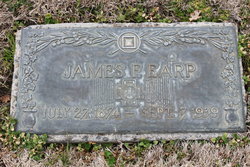
James Franklin Earp
| Birth | : | 27 Jul 1874 Colusa, Colusa County, California, USA |
| Death | : | 7 Sep 1939 Stanislaus County, California, USA |
| Burial | : | Modesto Pioneer Cemetery, Modesto, Stanislaus County, USA |
| Coordinate | : | 37.6473350, -120.9829040 |
| Plot | : | Section A Tier 13 Grave 56 |
| Description | : | James Franklin Earp was a Spanish-American War Veterin. He engaged in dry farming, first on his father's ranch, then in Sycamore [Colusa county]. When irrigation began in the San Joaquin Valley, he purchased a ranch in the Modesto area. In the spring of 1913, he sold his ranch and bought another in San Joaquin county. James Earp of Sycamore and Miss Eva Weis of Meridian were married at Marysville on Wednesday [27 Nov 1900] by Rev. A.G. Hunt. The groom was attended by C.R. Weis and the bride by Miss Ellen Griffen. They are both well known young people, the bride... Read More |
frequently asked questions (FAQ):
-
Where is James Franklin Earp's memorial?
James Franklin Earp's memorial is located at: Modesto Pioneer Cemetery, Modesto, Stanislaus County, USA.
-
When did James Franklin Earp death?
James Franklin Earp death on 7 Sep 1939 in Stanislaus County, California, USA
-
Where are the coordinates of the James Franklin Earp's memorial?
Latitude: 37.6473350
Longitude: -120.9829040
Family Members:
Parent
Spouse

Siblings
Flowers:


Nearby Cemetories:
1. Modesto Pioneer Cemetery
Modesto, Stanislaus County, USA
Coordinate: 37.6473350, -120.9829040
2. Acacia Memorial Park
Modesto, Stanislaus County, USA
Coordinate: 37.6481080, -120.9836610
3. Modesto Citizens Cemetery
Modesto, Stanislaus County, USA
Coordinate: 37.6472930, -120.9845570
4. Saint Stanislaus Catholic Cemetery
Modesto, Stanislaus County, USA
Coordinate: 37.6473610, -120.9808440
5. Modesto County Cemetery
Modesto, Stanislaus County, USA
Coordinate: 37.6492400, -120.9813800
6. Ceres Memorial Park
Ceres, Stanislaus County, USA
Coordinate: 37.5958214, -120.9634399
7. Lakewood Memorial Park
Hughson, Stanislaus County, USA
Coordinate: 37.6199760, -120.8975983
8. Good Shepherd Catholic Cemetery
Modesto, Stanislaus County, USA
Coordinate: 37.6853130, -121.0672890
9. Wood Colony Cemetery
Salida, Stanislaus County, USA
Coordinate: 37.6893730, -121.0682144
10. Burwood Cemetery
Escalon, San Joaquin County, USA
Coordinate: 37.7616997, -120.9593964
11. Langworth Cemetery
Oakdale, Stanislaus County, USA
Coordinate: 37.7580986, -120.8957977
12. Ripon Cemetery
Ripon, San Joaquin County, USA
Coordinate: 37.7420311, -121.1238708
13. Oakdale Citizens Cemetery
Oakdale, Stanislaus County, USA
Coordinate: 37.7624600, -120.8388800
14. Oaklawn Memorial Park
Oakdale, Stanislaus County, USA
Coordinate: 37.7711945, -120.8486862
15. Saint John's Catholic Cemetery
Escalon, San Joaquin County, USA
Coordinate: 37.7994537, -121.0705185
16. Denair Cemetery
Denair, Stanislaus County, USA
Coordinate: 37.5293999, -120.8199997
17. Martin Cemetery
Waterford, Stanislaus County, USA
Coordinate: 37.6684360, -120.7582160
18. Turlock Memorial Park
Turlock, Stanislaus County, USA
Coordinate: 37.4937592, -120.8659821
19. Grayson Cemetery
Grayson, Stanislaus County, USA
Coordinate: 37.5594559, -121.1802826
20. Valley Home Memorial Park
Oakdale, Stanislaus County, USA
Coordinate: 37.8275528, -120.9333267
21. Saint Francis Episcopal Church Columbarium
Turlock, Stanislaus County, USA
Coordinate: 37.5014300, -120.8368400
22. Patterson District Cemetery
Patterson, Stanislaus County, USA
Coordinate: 37.5268135, -121.1728287
23. Atlanta Cemetery
Five Corners, San Joaquin County, USA
Coordinate: 37.8270035, -121.1420135
24. North Hilmar Cemetery
Hilmar, Merced County, USA
Coordinate: 37.4146614, -120.8864288