
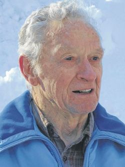

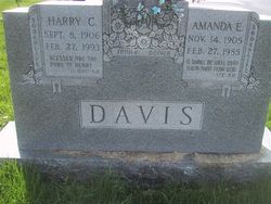
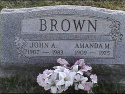
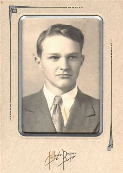
James Leroy “Jim” Brown
| Birth | : | 29 Apr 1922 Lantz, Frederick County, Maryland, USA |
| Death | : | 14 Mar 2021 Upper Marlboro, Prince George's County, Maryland, USA |
| Burial | : | Pequot Lakes City Cemetery, Pequot Lakes, Crow Wing County, USA |
| Coordinate | : | 46.6022200, -94.3180600 |
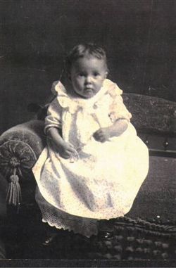
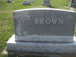
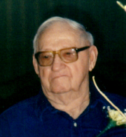
| Description | : | Married, Betty Jane Frazer, November 9,1941. James Leroy Brown of Upper Marlboro, Maryland, died March 14, 2021, some two months shy of his 99th birthday. The 12th of 14 children born to Ivan and Alta Royer Brown, James "Jim" spent most of his childhood in and around Lantz, Maryland where he was born, an area he referred to as "the mountain." He graduated from Thurmont High School in 1939 and began his 68-year marriage to Betty Frazer Brown in 1941. He was a machinist in the U.S. Navy, serving on a destroyer escort in the South Pacific during World... Read More |
frequently asked questions (FAQ):
-
Where is James Leroy “Jim” Brown's memorial?
James Leroy “Jim” Brown's memorial is located at: Pequot Lakes City Cemetery, Pequot Lakes, Crow Wing County, USA.
-
When did James Leroy “Jim” Brown death?
James Leroy “Jim” Brown death on 14 Mar 2021 in Upper Marlboro, Prince George's County, Maryland, USA
-
Where are the coordinates of the James Leroy “Jim” Brown's memorial?
Latitude: 46.6022200
Longitude: -94.3180600
Family Members:
Parent

Spouse
Siblings
Children

Flowers:


Nearby Cemetories:
1. Pequot Lakes City Cemetery
Pequot Lakes, Crow Wing County, USA
Coordinate: 46.6022200, -94.3180600
2. Our Saviors Lutheran Cemetery
Pequot Lakes, Crow Wing County, USA
Coordinate: 46.6028000, -94.3167000
3. Kedron Cemetery
Cass County, USA
Coordinate: 46.6022700, -94.3893300
4. Jenkins Cemetery
Jenkins, Crow Wing County, USA
Coordinate: 46.6542015, -94.3236008
5. Gravdahl Family Cemetery
Cass County, USA
Coordinate: 46.6173000, -94.3923100
6. Pelican Woods Cemetery and Nature Trail
Breezy Point, Crow Wing County, USA
Coordinate: 46.6024500, -94.2205310
7. Stoney Brook Cemetery
Cass County, USA
Coordinate: 46.5725000, -94.4097000
8. Greenwood Cemetery
Nisswa, Crow Wing County, USA
Coordinate: 46.5217000, -94.2803000
9. Mayo Brook Cemetery
Cass County, USA
Coordinate: 46.6156006, -94.4543991
10. Lutheran Church of the Cross Memorial Garden
Nisswa, Crow Wing County, USA
Coordinate: 46.5011200, -94.2955600
11. Living Savior Columbarium
Lake Shore, Cass County, USA
Coordinate: 46.5026450, -94.3535730
12. Norwood Cemetery
Crow Wing County, USA
Coordinate: 46.7036018, -94.2891998
13. Pineswood Cemetery
Lake Hubert, Crow Wing County, USA
Coordinate: 46.4964400, -94.2820200
14. Thorp-Heald Cemetery
Lake Hubert, Crow Wing County, USA
Coordinate: 46.5022000, -94.2537000
15. Pleasant Hill Cemetery
Cass County, USA
Coordinate: 46.5436000, -94.4570500
16. Shamps Cemetery
Pine River, Cass County, USA
Coordinate: 46.7182007, -94.3618317
17. Pine Ridge Cemetery
Pine River, Cass County, USA
Coordinate: 46.7078514, -94.4013977
18. Lake Shore Memorial Garden Cemetery
Cass County, USA
Coordinate: 46.4860760, -94.3767600
19. Maple Hill Cemetery
Cass County, USA
Coordinate: 46.6459100, -94.4918000
20. Anderson Cemetery
Cass County, USA
Coordinate: 46.6446991, -94.4925003
21. Lake Edward Cemetery
Crow Wing County, USA
Coordinate: 46.4981003, -94.2035980
22. Pinewood Cemetery
Crosslake, Crow Wing County, USA
Coordinate: 46.6464005, -94.1089020
23. Moose Lake Cemetery
Cass County, USA
Coordinate: 46.5727997, -94.5453033
24. Swanburg Cemetery
Crow Wing County, USA
Coordinate: 46.7393990, -94.1564026