

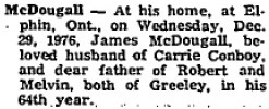
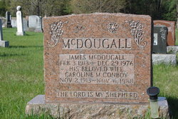
James McDougall
| Birth | : | 3 Feb 1913 |
| Death | : | 29 Dec 1976 |
| Burial | : | St John the Baptist Churchyard, Keele, Newcastle-Under-Lyme Borough, England |
| Coordinate | : | 53.0039410, -2.2848720 |
| Plot | : | 314 |
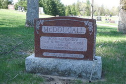
| Description | : | Plot 314 : - James McDougall, Feb.3,1913 - Dec.29,1976 - his beloved wife, - Caroline M. Conboy, Nov.2,1913 - Nov.6,1988 |
frequently asked questions (FAQ):
-
Where is James McDougall's memorial?
James McDougall's memorial is located at: St John the Baptist Churchyard, Keele, Newcastle-Under-Lyme Borough, England.
-
When did James McDougall death?
James McDougall death on 29 Dec 1976 in
-
Where are the coordinates of the James McDougall's memorial?
Latitude: 53.0039410
Longitude: -2.2848720
Family Members:
Parent


Spouse
Siblings
Flowers:


Nearby Cemetories:
1. St John the Baptist Churchyard
Keele, Newcastle-Under-Lyme Borough, England
Coordinate: 53.0039410, -2.2848720
2. Keele Cemetery
Keele, Newcastle-Under-Lyme Borough, England
Coordinate: 53.0087192, -2.2813113
3. St Luke the Evangelist Churchyard
Silverdale, Newcastle-Under-Lyme Borough, England
Coordinate: 53.0170300, -2.2736770
4. Silverdale Cemetery
Silverdale, Newcastle-Under-Lyme Borough, England
Coordinate: 53.0135400, -2.2559520
5. Newcastle-Under-Lyme Knutton Cemetery
Newcastle-under-Lyme, Newcastle-Under-Lyme Borough, England
Coordinate: 53.0220500, -2.2495100
6. St. John Churchyard
Alsagers Bank, Newcastle-Under-Lyme Borough, England
Coordinate: 53.0365350, -2.2939860
7. St. Giles' Churchyard
Newcastle-under-Lyme, Newcastle-Under-Lyme Borough, England
Coordinate: 53.0115110, -2.2301920
8. Newcastle Cemetery
Newcastle-under-Lyme, Newcastle-Under-Lyme Borough, England
Coordinate: 53.0062940, -2.2284440
9. All Saints Churchyard
Madeley, Newcastle-Under-Lyme Borough, England
Coordinate: 52.9962463, -2.3400240
10. Madeley Cemetery
Madeley, Newcastle-Under-Lyme Borough, England
Coordinate: 52.9878150, -2.3395660
11. St Mary and All Saints Churchyard
Whitmore, Newcastle-Under-Lyme Borough, England
Coordinate: 52.9663190, -2.2838270
12. Chesterton Cemetery
Newcastle-under-Lyme, Newcastle-Under-Lyme Borough, England
Coordinate: 53.0352240, -2.2500500
13. St. George's Churchyard
Newcastle-under-Lyme, Newcastle-Under-Lyme Borough, England
Coordinate: 53.0141190, -2.2242070
14. Holy Trinity Churchyard
Chesterton, Stratford-on-Avon District, England
Coordinate: 53.0418320, -2.2523770
15. Hartshill Cemetery
Hartshill, Stoke-on-Trent Unitary Authority, England
Coordinate: 53.0054283, -2.2035301
16. St Margaret Churchyard
Wolstanton, Newcastle-Under-Lyme Borough, England
Coordinate: 53.0296810, -2.2154990
17. St James the Great Churchyard
Audley, Newcastle-Under-Lyme Borough, England
Coordinate: 53.0548480, -2.3014800
18. Audley Cemetery
Audley, Newcastle-Under-Lyme Borough, England
Coordinate: 53.0550140, -2.3103040
19. St Thomas the Apostle Churchyard
Penkhull, Stoke-on-Trent Unitary Authority, England
Coordinate: 53.0004170, -2.1964040
20. Audley Methodist Church Cemetery
Bignall End, Newcastle-Under-Lyme Borough, England
Coordinate: 53.0574320, -2.2944720
21. Etruria Methodist Church
Stoke-on-Trent, Stoke-on-Trent Unitary Authority, England
Coordinate: 53.0209680, -2.1985840
22. St Margaret Churchyard
Betley, Newcastle-Under-Lyme Borough, England
Coordinate: 53.0328100, -2.3658530
23. St. Matthias Churchyard
Hanford, Stoke-on-Trent Unitary Authority, England
Coordinate: 52.9812170, -2.1962980
24. Quakers Burial Ground
Stoke-on-Trent, Stoke-on-Trent Unitary Authority, England
Coordinate: 53.0052870, -2.1881570