

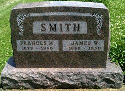
James Warren Smith
| Birth | : | 23 Jan 1868 Pickering, Nodaway County, Missouri, USA |
| Death | : | 27 May 1950 Pickering, Nodaway County, Missouri, USA |
| Burial | : | Big Isaac Cemetery, Doddridge County, USA |
| Coordinate | : | 39.2022018, -80.5468979 |
| Plot | : | Row - N to S |
frequently asked questions (FAQ):
-
Where is James Warren Smith's memorial?
James Warren Smith's memorial is located at: Big Isaac Cemetery, Doddridge County, USA.
-
When did James Warren Smith death?
James Warren Smith death on 27 May 1950 in Pickering, Nodaway County, Missouri, USA
-
Where are the coordinates of the James Warren Smith's memorial?
Latitude: 39.2022018
Longitude: -80.5468979
Family Members:
Parent
Spouse
Siblings

Flowers:


Nearby Cemetories:
1. Big Isaac Cemetery
Doddridge County, USA
Coordinate: 39.2022018, -80.5468979
2. Day Cemetery
Harrison County, USA
Coordinate: 39.2172012, -80.5325012
3. Mount Lebanon Cemetery
Harrison County, USA
Coordinate: 39.1721992, -80.5603027
4. Morris Cemetery
Benson, Harrison County, USA
Coordinate: 39.1669006, -80.5547028
5. Eddy Cemetery
Miletus, Doddridge County, USA
Coordinate: 39.2321820, -80.5882890
6. Mount Carmel Cemetery
Kincheloe, Harrison County, USA
Coordinate: 39.1693993, -80.5056000
7. Mount Olive Cemetery
Doddridge County, USA
Coordinate: 39.2467003, -80.5721970
8. Green Hill Cemetery
Harrison County, USA
Coordinate: 39.1610080, -80.5112400
9. Greenbrier Seventh Day Baptist Cemetery
Doddridge County, USA
Coordinate: 39.2472000, -80.5830994
10. Jarvisville Baptist Church Cemetery
Jarvisville, Harrison County, USA
Coordinate: 39.2342090, -80.4902440
11. Pleasant Hill Cemetery
Doddridge County, USA
Coordinate: 39.2125015, -80.6185989
12. Snider Cemetery
Doddridge County, USA
Coordinate: 39.1913986, -80.6260986
13. Law Chapel Cemetery
Lewis County, USA
Coordinate: 39.1374670, -80.5739770
14. Pleasant Hill United Methodist Church Cemetery
Harrison County, USA
Coordinate: 39.1469990, -80.4944340
15. Upper Little Indian Fork Cemetery
Coldwater, Doddridge County, USA
Coordinate: 39.1632996, -80.6296997
16. Indian Fork Cemetery
Doddridge County, USA
Coordinate: 39.1739006, -80.6380997
17. Coplin Church Cemetery
Salem, Harrison County, USA
Coordinate: 39.2636420, -80.4861850
18. Smith Chapel Cemetery
Doddridge County, USA
Coordinate: 39.2606010, -80.6175003
19. Seventh-Day Baptist Church Cemetery
Salem, Harrison County, USA
Coordinate: 39.2828510, -80.5550730
20. Mount Zion Baptist Church Cemetery
Weston, Lewis County, USA
Coordinate: 39.1182850, -80.5699220
21. Odd Fellows Cemetery
Salem, Harrison County, USA
Coordinate: 39.2887000, -80.5560000
22. Good Hope Masonic Cemetery
Goodhope, Harrison County, USA
Coordinate: 39.1772300, -80.4393600
23. New Bethel Cemetery
Harrison County, USA
Coordinate: 39.1772003, -80.4392014
24. Post Cemetery
Harrison County, USA
Coordinate: 39.1631012, -80.4413986