
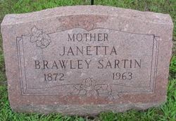
Janetta Leslie Sartin
| Birth | : | 16 Nov 1872 Greer, Oregon County, Missouri, USA |
| Death | : | 4 Oct 1963 Columbia, Boone County, Missouri, USA |
| Burial | : | Cementerio Municipal Viejo, Yauco, Yauco Municipality, USA |
| Coordinate | : | 18.0356000, -66.8561600 |
| Inscription | : | Mother |
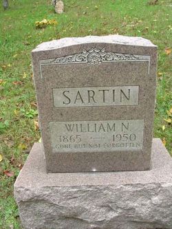
| Description | : | Janetta was a daughter of Dr. William Gordon Leslie and Emeline E. Wright. Married (1)John M. Brawley on Nov. 9, 1890; (2) William N. Sartin on Oct. 3, 1938 (by Justice of Peace). Widowed twice. Believed to be buried here. [Source: Donita Barkley] At the time of her death, Janetta was living in Fremont, Carter County, MO. She died of injuries nine days after a car accident which had occurred on September 25, 1863 in Boone County. The death certificate (MO Death Certificate # 63-035103) confirms removal and burial at Oak Grove Cemetery,... Read More |
frequently asked questions (FAQ):
-
Where is Janetta Leslie Sartin's memorial?
Janetta Leslie Sartin's memorial is located at: Cementerio Municipal Viejo, Yauco, Yauco Municipality, USA.
-
When did Janetta Leslie Sartin death?
Janetta Leslie Sartin death on 4 Oct 1963 in Columbia, Boone County, Missouri, USA
-
Where are the coordinates of the Janetta Leslie Sartin's memorial?
Latitude: 18.0356000
Longitude: -66.8561600
Family Members:
Parent
Spouse
Siblings
Children
Flowers:


Nearby Cemetories:
1. Cementerio Municipal Viejo
Yauco, Yauco Municipality, USA
Coordinate: 18.0356000, -66.8561600
2. Cementerio Municipal Nuevo
Yauco, Yauco Municipality, USA
Coordinate: 18.0353500, -66.8568700
3. Santa Basilica Metropolitana Iglesia Catedral
Santiago de Cuba, Municipio de Santiago de Cuba, Cuba
Coordinate: 18.0384400, -66.8712700
4. Cementerio Nuevo Los Pinos
Guayanilla, Guayanilla Municipality, USA
Coordinate: 18.0172020, -66.7952230
5. Cementerio Municipal de Guayanilla
Guayanilla, Guayanilla Municipality, USA
Coordinate: 18.0247726, -66.7870865
6. Cementerio Municipal de Guanica
Guanica, Guanica Municipality, USA
Coordinate: 17.9800910, -66.9204540
7. Getsemaní Memorial Park
Susua, Sabana Grande Municipality, USA
Coordinate: 18.0825900, -66.9439900
8. Cementerio Masónico Sabana Grande
Sabana Grande, Sabana Grande Municipality, USA
Coordinate: 18.0801400, -66.9678500
9. Cementerio Municipal
Sabana Grande, Sabana Grande Municipality, USA
Coordinate: 18.0802212, -66.9678879
10. Cementerio Penuelas
Penuelas, Penuelas Municipality, USA
Coordinate: 18.0557080, -66.7260120
11. Cementerio Municipal Yahuecas
Adjuntas, Adjuntas Municipality, USA
Coordinate: 18.1885900, -66.7773100
12. Cementerio Río Prieto
Castaner, Lares Municipality, USA
Coordinate: 18.2085125, -66.8974098
13. Cementerio Luz del Gigante
Adjuntas, Adjuntas Municipality, USA
Coordinate: 18.1658260, -66.7290920
14. Cementerio Porta Coeli
San German, San German Municipality, USA
Coordinate: 18.0904730, -67.0385420
15. Camposanto de Cristo Resucitado
Ponce, Ponce Municipality, USA
Coordinate: 17.9791720, -66.6655760
16. Cementerio Municipal
Maricao, Maricao Municipality, USA
Coordinate: 18.1855520, -66.9833010
17. Antiguo Cementerio Municipal
San German, San German Municipality, USA
Coordinate: 18.0825750, -67.0527120
18. Cementerio Trujillo
San German, San German Municipality, USA
Coordinate: 18.0816680, -67.0532020
19. Cementerio Municipal De Lajas
Lajas, Lajas Municipality, USA
Coordinate: 18.0448700, -67.0610500
20. Cementerio La Piedad
Ponce, Ponce Municipality, USA
Coordinate: 18.0409320, -66.6462850
21. Cementerio Católico San Vicente de Paul
Ponce, Ponce Municipality, USA
Coordinate: 18.0170790, -66.6337570
22. Cementerio Civil de Ponce
Ponce, Ponce Municipality, USA
Coordinate: 18.0146870, -66.6326730
23. Cementerio El Yeso
Ponce, Ponce Municipality, USA
Coordinate: 18.0351250, -66.6243110
24. Cementerio Municipal de la Playa
Ponce, Ponce Municipality, USA
Coordinate: 17.9848850, -66.6288700