
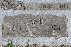
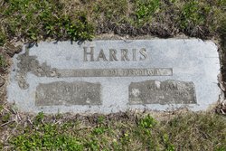
Janie Sophia Smathers Harris
| Birth | : | 11 Jan 1891 Wilkesville, Vinton County, Ohio, USA |
| Death | : | 10 Oct 1974 Okanogan, Okanogan County, Washington, USA |
| Burial | : | Mountain View Memorial Cemetery, Ellisforde, Okanogan County, USA |
| Coordinate | : | 48.8328300, -119.4011300 |
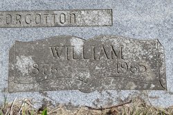
| Description | : | Ohio, Births and Christenings Index, 1800-1962 Name:Sophia J. Smathers Gender:Female Birth Place:Wilkesville, Vinton, Ohio Birth Date:11 Jan 1891 Father's Name:Andrew Smathers (1866-1940) Mother's Name:Louisa Stephenson (1960-1932) FHL Film Number:311575 West Virginia, Marriages Index, 1785-1971 Name:Walter G Johnson Gender:Male Birth Date:abt 1888 Age:20 Spouse's Name:Janie Smathers Spouse Gender:Female Spouse Age:17 Marriage Date:2 Sep 1908 Marriage Place:Minden, Fayette, West Virginia Father's Name:L H Mother's Name:Mary F Spouse Father's Name:Andy Spouse Mother's Name:Lou West Virginia, Marriages Index, 1785-1971 Name:Wm Harris Gender:Male Birth Date:abt 1877 Age:44 Spouse's Name:Janie Johnson Spouse Gender:Female Spouse Age:30 Marriage Date:1 Jan 1921 Marriage Place:Minden, Fayette, West Virginia Father's Name:Parker Mother's Name:Ruth Spouse Father's Name:Andy Spouse Mother's Name:Louisa She was the first daughter of Andrew and Sophie Smathers. She and her sister and three brothers spent their childhood in the coal mining... Read More |
frequently asked questions (FAQ):
-
Where is Janie Sophia Smathers Harris's memorial?
Janie Sophia Smathers Harris's memorial is located at: Mountain View Memorial Cemetery, Ellisforde, Okanogan County, USA.
-
When did Janie Sophia Smathers Harris death?
Janie Sophia Smathers Harris death on 10 Oct 1974 in Okanogan, Okanogan County, Washington, USA
-
Where are the coordinates of the Janie Sophia Smathers Harris's memorial?
Latitude: 48.8328300
Longitude: -119.4011300
Family Members:
Spouse
Children

Flowers:


Nearby Cemetories:
1. Mountain View Memorial Cemetery
Ellisforde, Okanogan County, USA
Coordinate: 48.8328300, -119.4011300
2. Ellisforde Mission Cemetery
Ellisforde, Okanogan County, USA
Coordinate: 48.7908300, -119.3972300
3. Old Oroville Cemetery
Okanogan County, USA
Coordinate: 48.8913360, -119.4456230
4. Old Riverview Cemetery
Oroville, Okanogan County, USA
Coordinate: 48.9177800, -119.4466700
5. Oroville Riverview Cemetery
Oroville, Okanogan County, USA
Coordinate: 48.9202700, -119.4458500
6. Golden Cemetery
Okanogan County, USA
Coordinate: 48.9014015, -119.5203018
7. Tonasket Cemetery
Tonasket, Okanogan County, USA
Coordinate: 48.7284400, -119.4328200
8. Immanuel Lutheran Cemetery
Havillah, Okanogan County, USA
Coordinate: 48.8305500, -119.2033500
9. Mountain View Cemetery
Loomis, Okanogan County, USA
Coordinate: 48.8152700, -119.6100100
10. Little Chopaka Cemetery
Okanogan County, USA
Coordinate: 48.8272200, -119.6430600
11. Kipling Cemetery
Okanogan County, USA
Coordinate: 48.9080500, -119.1652900
12. Molson Cemetery
Molson, Okanogan County, USA
Coordinate: 48.9657000, -119.2105000
13. Anglin Cemetery
Okanogan County, USA
Coordinate: 48.6627700, -119.2783400
14. Phillip Raux Gravesite
Riverside, Okanogan County, USA
Coordinate: 48.6271800, -119.3308500
15. Sidley-Lawless Cemetery
Sidley, Kootenay Boundary Regional District, Canada
Coordinate: 49.0153330, -119.2234330
16. Cook Place Cemetery
Tonasket, Okanogan County, USA
Coordinate: 48.6083330, -119.3544440
17. Cook Family Cemetery
Carlton, Okanogan County, USA
Coordinate: 48.6083300, -119.3544400
18. Wauconda Cemetery
Wauconda, Okanogan County, USA
Coordinate: 48.7408300, -119.0597300
19. Osoyoos Lakeview Cemetery
Osoyoos, Okanagan-Similkameen Regional District, Canada
Coordinate: 49.0638600, -119.5185500
20. Chesaw Cemetery
Okanogan County, USA
Coordinate: 48.9299900, -119.0541800
21. Pine Creek Cemetery
Tonasket, Okanogan County, USA
Coordinate: 48.6330560, -119.6502780
22. South Pine Creek Cemetery
Riverside, Okanogan County, USA
Coordinate: 48.5925900, -119.5663400
23. Bridesville Cemetery
Bridesville, Kootenay Boundary Regional District, Canada
Coordinate: 49.0370800, -119.1372300
24. Thorp Cemetery
Chesaw, Okanogan County, USA
Coordinate: 48.9549900, -119.0316700