
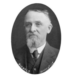
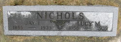
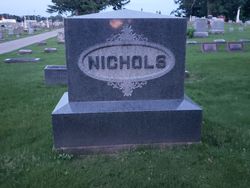
Jay Ira Nichols
| Birth | : | 13 May 1855 Muscatine County, Iowa, USA |
| Death | : | 26 Apr 1935 USA |
| Burial | : | Hillside Cemetery, Columbus, Columbia County, USA |
| Coordinate | : | 43.3470001, -89.0139999 |
| Plot | : | Old Oak Blk 54/Lot 4/Sp 1 |
| Description | : | Source: History of Muscatine County Iowa, Volume II, Biographical, 1911, page 388 JAY IRA NICHOLS. The owner of a valuable farm of three hundred acres of good land in Muscatine county, the Hon. Jay I. Nichols has attained success financially. He has also been honored by his fellow citizens with important public offices, which he has filled with the highest credit. He ranks today as one of the leading men of the county and is recognized throughout the state as a man of marked ability who has assisted in no small degree in advancing the permanent interests of Iowa. A native of... Read More |
frequently asked questions (FAQ):
-
Where is Jay Ira Nichols's memorial?
Jay Ira Nichols's memorial is located at: Hillside Cemetery, Columbus, Columbia County, USA.
-
When did Jay Ira Nichols death?
Jay Ira Nichols death on 26 Apr 1935 in USA
-
Where are the coordinates of the Jay Ira Nichols's memorial?
Latitude: 43.3470001
Longitude: -89.0139999
Family Members:
Parent

Spouse

Siblings

Children
Flowers:


Nearby Cemetories:
1. Hillside Cemetery
Columbus, Columbia County, USA
Coordinate: 43.3470001, -89.0139999
2. Saint Jeromes Cemetery
Columbus, Columbia County, USA
Coordinate: 43.3452720, -89.0179900
3. Bethel Cemetery
Dodge County, USA
Coordinate: 43.3657990, -88.9800034
4. Fall River Cemetery
Fall River, Columbia County, USA
Coordinate: 43.3932991, -89.0350037
5. Okeeg Cemetery
Danville, Dodge County, USA
Coordinate: 43.3250008, -88.9524994
6. Elba Cemetery
Portland, Dodge County, USA
Coordinate: 43.2855988, -88.9649963
7. Saint Columbkille Catholic Cemetery
Elba, Dodge County, USA
Coordinate: 43.3079491, -88.9291229
8. Salem Cemetery
Calamus, Dodge County, USA
Coordinate: 43.3963800, -88.9331600
9. Bethany Cemetery
Calamus, Dodge County, USA
Coordinate: 43.4152985, -88.9653015
10. Austin Cemetery
Portland, Dodge County, USA
Coordinate: 43.2849541, -88.9461746
11. East York Cemetery
York Center, Dane County, USA
Coordinate: 43.2672200, -89.0357971
12. Fountain Prairie Cemetery
Columbia County, USA
Coordinate: 43.4063988, -89.0942001
13. North York Cemetery
York Center, Dane County, USA
Coordinate: 43.2682690, -89.0763570
14. German Methodist Cemetery
Portland, Dodge County, USA
Coordinate: 43.2485940, -89.0002200
15. Grove Prairie Cemetery
Reeseville, Dodge County, USA
Coordinate: 43.3361015, -88.8775024
16. Saint Stephens Cemetery
Englewood, Columbia County, USA
Coordinate: 43.4286000, -89.0945600
17. Wanderers Rest Cemetery
Lost Lake, Dodge County, USA
Coordinate: 43.4500237, -88.9901352
18. Oak Lawn Cemetery
York Center, Dane County, USA
Coordinate: 43.2536087, -89.0883331
19. Annunciation Cemetery
Lost Lake, Dodge County, USA
Coordinate: 43.4583200, -88.9920500
20. Saint Peter Cemetery
East Bristol, Dane County, USA
Coordinate: 43.2682450, -89.1327130
21. Trinity Lutheran Cemetery
Lowell, Dodge County, USA
Coordinate: 43.2782830, -88.8830420
22. Leipsig Cemetery
Beaver Dam, Dodge County, USA
Coordinate: 43.4063800, -88.8734400
23. Evangelical Reformed Cemetery
Lowell, Dodge County, USA
Coordinate: 43.2742370, -88.8853600
24. Otsego Cemetery
Otsego, Columbia County, USA
Coordinate: 43.3991500, -89.1645600