
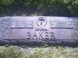
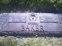
Jay Virgil Baker
| Birth | : | 25 Oct 1897 Kansas, USA |
| Death | : | 9 Mar 1962 Phoenix, Maricopa County, Arizona, USA |
| Burial | : | Otho Cemetery, Otho, Webster County, USA |
| Coordinate | : | 42.4025002, -94.1153030 |
frequently asked questions (FAQ):
-
Where is Jay Virgil Baker's memorial?
Jay Virgil Baker's memorial is located at: Otho Cemetery, Otho, Webster County, USA.
-
When did Jay Virgil Baker death?
Jay Virgil Baker death on 9 Mar 1962 in Phoenix, Maricopa County, Arizona, USA
-
Where are the coordinates of the Jay Virgil Baker's memorial?
Latitude: 42.4025002
Longitude: -94.1153030
Family Members:
Parent
Spouse
Siblings

Children
Flowers:


Nearby Cemetories:
1. Otho Cemetery
Otho, Webster County, USA
Coordinate: 42.4025002, -94.1153030
2. Holaday Creek Cemetery
Webster County, USA
Coordinate: 42.4472008, -94.0886002
3. Border Plains Cemetery
Border Plains, Webster County, USA
Coordinate: 42.3917000, -94.0448000
4. West Lawn Cemetery
Lehigh, Webster County, USA
Coordinate: 42.3616982, -94.0678024
5. Graceland Cemetery
Elkhorn Township, Webster County, USA
Coordinate: 42.4275017, -94.2127991
6. Oak Grove Cemetery
Lehigh, Webster County, USA
Coordinate: 42.3438988, -94.0475006
7. Blanchard Cemetery
Webster County, USA
Coordinate: 42.4021988, -93.9997025
8. Ober and Scott Cemetery
Duncombe, Webster County, USA
Coordinate: 42.3841390, -93.9982856
9. Elkhorn Cemetery
Webster County, USA
Coordinate: 42.4277992, -94.2328033
10. Elkhorn Township Cemetery
Fort Dodge, Webster County, USA
Coordinate: 42.4276120, -94.2329690
11. Webster County Home Cemetery
Fort Dodge, Webster County, USA
Coordinate: 42.4563710, -94.2181420
12. Washington Cemetery
Duncombe, Webster County, USA
Coordinate: 42.4277992, -93.9916992
13. Fort Dodge Memorial Park
Fort Dodge, Webster County, USA
Coordinate: 42.5032997, -94.1472015
14. Hartman Cemetery
Lehigh, Webster County, USA
Coordinate: 42.3666397, -93.9835627
15. Washington Township Cemetery
Duncombe, Webster County, USA
Coordinate: 42.4707900, -94.0002000
16. McGuire Bend Cemetery
Dayton, Webster County, USA
Coordinate: 42.3410000, -93.9880000
17. Saint Josephs Cemetery
Duncombe, Webster County, USA
Coordinate: 42.4789009, -93.9922028
18. Saint Olafs Cemetery
Fort Dodge, Webster County, USA
Coordinate: 42.5017014, -94.2153015
19. Carpenter Cemetery
Webster County, USA
Coordinate: 42.5015907, -94.2166061
20. Saron Lutheran Cemetery
Callender, Webster County, USA
Coordinate: 42.3690720, -94.2780609
21. Callender Cemetery
Callender, Webster County, USA
Coordinate: 42.3693237, -94.2793427
22. Vinje Cemetery
Callender, Webster County, USA
Coordinate: 42.3693237, -94.2797775
23. Oakland Cemetery
Fort Dodge, Webster County, USA
Coordinate: 42.5214005, -94.1800003
24. Bass Cemetery
Dayton, Webster County, USA
Coordinate: 42.2966995, -94.0149994