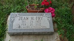
Jean Marie Brownlee Fry
| Birth | : | 23 Dec 1927 Popejoy, Franklin County, Iowa, USA |
| Death | : | 20 Feb 2012 Rockwell, Cerro Gordo County, Iowa, USA |
| Burial | : | Elmwood Saint Joseph Cemetery, Mason City, Cerro Gordo County, USA |
| Coordinate | : | 43.1399994, -93.2067032 |
| Plot | : | Roselawn Lot 216 - 3 |
| Description | : | Jean Marie Fry, 84, of 425 20th Street S.W., Mason City died Monday, Feb. 20, 2012 at the Rockwell Community Nursing Home. Funeral services for Jean will be held at 10:30 a.m, Thursday, Feb. 23, at Hogan Bremer Moore Colonial Chapel, 126 Third St. N.E., Mason City with the Reverend Sid Bohls officiating. Burial will be held at Elmwood-St. Joseph Cemetery, Mason City. Visitation will be held from 5 to 7 p.m., today, Wednesday, Feb. 22, at Hogan Bremer Moore Colonial Chapel. Memorial contributions may be designated to the Jean Fry Memorial Fund in care of the family. Jean Marie Fry was one of... Read More |
frequently asked questions (FAQ):
-
Where is Jean Marie Brownlee Fry's memorial?
Jean Marie Brownlee Fry's memorial is located at: Elmwood Saint Joseph Cemetery, Mason City, Cerro Gordo County, USA.
-
When did Jean Marie Brownlee Fry death?
Jean Marie Brownlee Fry death on 20 Feb 2012 in Rockwell, Cerro Gordo County, Iowa, USA
-
Where are the coordinates of the Jean Marie Brownlee Fry's memorial?
Latitude: 43.1399994
Longitude: -93.2067032
Family Members:
Parent
Spouse
Siblings
Flowers:
Nearby Cemetories:
1. Elmwood Saint Joseph Cemetery
Mason City, Cerro Gordo County, USA
Coordinate: 43.1399994, -93.2067032
2. IOOF Cemetery
Mason City, Cerro Gordo County, USA
Coordinate: 43.1336975, -93.2139130
3. First Congregational UCC Columbarium
Mason City, Cerro Gordo County, USA
Coordinate: 43.1529720, -93.1990410
4. Saint Johns Episcopal Church Columbarium
Mason City, Cerro Gordo County, USA
Coordinate: 43.1528900, -93.1980730
5. Memorial Park Cemetery
Mason City, Cerro Gordo County, USA
Coordinate: 43.1469002, -93.2936020
6. Owens Grove Cemetery
Cerro Gordo County, USA
Coordinate: 43.0825005, -93.1144180
7. Rock Falls Cemetery
Rock Falls, Cerro Gordo County, USA
Coordinate: 43.2122192, -93.0858307
8. Clear Lake Cemetery
Clear Lake, Cerro Gordo County, USA
Coordinate: 43.1422195, -93.3658295
9. Bohemian Cemetery
Plymouth, Cerro Gordo County, USA
Coordinate: 43.2522011, -93.1252975
10. Oakwood Cemetery
Plymouth, Cerro Gordo County, USA
Coordinate: 43.2538986, -93.1252975
11. Mount Vernon Cemetery
Mount Vernon Township, Cerro Gordo County, USA
Coordinate: 43.0374985, -93.3181000
12. Spring Grove Cemetery
Nora Springs, Floyd County, USA
Coordinate: 43.1631012, -93.0211029
13. Lincoln Township Cemetery
Cerro Gordo County, USA
Coordinate: 43.2419014, -93.3460999
14. Buddy Holly Crash Site
Clear Lake, Cerro Gordo County, USA
Coordinate: 43.2203400, -93.3814100
15. Manly Cemetery
Manly, Worth County, USA
Coordinate: 43.2905617, -93.1999969
16. Sacred Heart Catholic Church Cemetery
Manly, Worth County, USA
Coordinate: 43.2911110, -93.2013931
17. Park Cemetery
Nora Springs, Floyd County, USA
Coordinate: 43.1444016, -92.9982986
18. Freddie Hensel Burial Site
Plymouth Junction, Cerro Gordo County, USA
Coordinate: 43.2827034, -93.1317902
19. Forest Lawn Memorial Garden
Clear Lake, Cerro Gordo County, USA
Coordinate: 43.1403008, -93.4207993
20. Rock Grove Township Cemetery
Nora Springs, Floyd County, USA
Coordinate: 43.1227989, -92.9880981
21. Rockwell Cemetery
Rockwell, Cerro Gordo County, USA
Coordinate: 42.9786000, -93.1919000
22. Sacred Heart Cemetery
Rockwell, Cerro Gordo County, USA
Coordinate: 42.9592018, -93.1913986
23. Clear Lake Township Cemetery
Ventura, Cerro Gordo County, USA
Coordinate: 43.1234000, -93.4772000
24. Grant Center Cemetery
Cerro Gordo County, USA
Coordinate: 43.2285995, -93.4505997

