
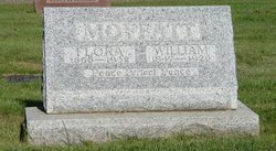
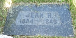
Jeanie Harriet “Jean” Moir Moffatt
| Birth | : | 17 Feb 1884 Lanark, Lanark County, Ontario, Canada |
| Death | : | 15 Jan 1943 Calgary, Calgary Census Division, Alberta, Canada |
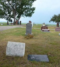
| Burial | : | Van Hoosen Jones Stoney Creek Cemetery, Rochester, Oakland County, USA |
| Coordinate | : | 42.6953468, -83.1228256 |
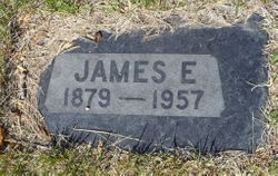
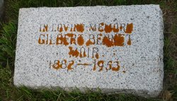
| Description | : | ONTARIO BIRTH REGISTER Name Jeanie Harriet Moir Date of Birth 17 Feb 1884 Gender Female Birth Place Lanark, Ontario, Canada Father's Name David Moir Mother's Name Margaret Naismith -------------- ONTARIO MARRIAGE REGISTER Name: Jean Harriett Moir Age: 21 Birth Year: abt 1884 Birth Place: Ramsey, Ontario Marriage Date: 7 Jun 1905 Marriage Place: Lanark, Ontario, Canada Father: David Moir Mother: Maggie Naismith Spouse: James Eric Moffatt --------------------- CLARESHOLM LOCAL PRESS Claresholm, Alberta, Thursday, January 21 1943 MRS ERIC MOFFATT DIES SUDDENLY Mrs Jean Harriett Moffatt, wife of Eric Moffatt of Calgary, one of Claresholm's very earliest citizens,... Read More |
frequently asked questions (FAQ):
-
Where is Jeanie Harriet “Jean” Moir Moffatt's memorial?
Jeanie Harriet “Jean” Moir Moffatt's memorial is located at: Van Hoosen Jones Stoney Creek Cemetery, Rochester, Oakland County, USA.
-
When did Jeanie Harriet “Jean” Moir Moffatt death?
Jeanie Harriet “Jean” Moir Moffatt death on 15 Jan 1943 in Calgary, Calgary Census Division, Alberta, Canada
-
Where are the coordinates of the Jeanie Harriet “Jean” Moir Moffatt's memorial?
Latitude: 42.6953468
Longitude: -83.1228256
Family Members:
Parent
Spouse
Siblings
Children


Nearby Cemetories:
1. Van Hoosen Jones Stoney Creek Cemetery
Rochester, Oakland County, USA
Coordinate: 42.6953468, -83.1228256
2. Old Stoney Creek Cemetery
Rochester Hills, Oakland County, USA
Coordinate: 42.6917000, -83.1205978
3. Mount Avon Cemetery
Rochester, Oakland County, USA
Coordinate: 42.6772003, -83.1421967
4. Guardian Angel Cemetery
Rochester, Oakland County, USA
Coordinate: 42.7307892, -83.1354218
5. Curtis Cemetery
Shelby Township, Macomb County, USA
Coordinate: 42.6955986, -83.0693970
6. Christian Memorial Gardens West
Rochester Hills, Oakland County, USA
Coordinate: 42.6543999, -83.1235962
7. Brewster Cemetery
Rochester Hills, Oakland County, USA
Coordinate: 42.7019005, -83.1853027
8. Memorial Garden
Shelby Township, Macomb County, USA
Coordinate: 42.7011589, -83.0550083
9. Ewell Cemetery
Shelby Township, Macomb County, USA
Coordinate: 42.6690520, -83.0631500
10. Cannon Cemetery
Washington, Macomb County, USA
Coordinate: 42.7131882, -83.0555267
11. South Washington Cemetery
Washington, Macomb County, USA
Coordinate: 42.7139015, -83.0558014
12. Mount Vernon Cemetery
Mount Vernon, Macomb County, USA
Coordinate: 42.7414570, -83.0862950
13. Paint Creek Cemetery
Lake Orion, Oakland County, USA
Coordinate: 42.7472000, -83.1802979
14. Kline Cemetery
Rochester, Oakland County, USA
Coordinate: 42.7686005, -83.1378021
15. Conner-Price Cemetery
Shelby Township, Macomb County, USA
Coordinate: 42.6603165, -83.0293427
16. Bigler Cemetery
Oakland Township, Oakland County, USA
Coordinate: 42.7386017, -83.2149963
17. Saint Lawrence Cemetery
Utica, Macomb County, USA
Coordinate: 42.6319008, -83.0507965
18. Utica Cemetery
Utica, Macomb County, USA
Coordinate: 42.6373291, -83.0378952
19. Washington Center Cemetery
Washington, Macomb County, USA
Coordinate: 42.7566986, -83.0417023
20. Saint John Cemetery
Shelby Township, Macomb County, USA
Coordinate: 42.6991690, -83.0065580
21. Prestonville Cemetery
Shelby Township, Macomb County, USA
Coordinate: 42.7000810, -83.0043200
22. Union Corners Cemetery
Troy, Oakland County, USA
Coordinate: 42.6074982, -83.1256027
23. Clifton Cemetery
Clifton Mill, Macomb County, USA
Coordinate: 42.7900009, -83.0991974
24. Aaron Webster Cemetery
Auburn Hills, Oakland County, USA
Coordinate: 42.6316605, -83.2230606