
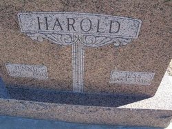
Jennie A. Houtsma Harold
| Birth | : | 4 Aug 1890 Decatur County, Kansas, USA |
| Death | : | 17 Feb 1980 McPherson, McPherson County, Kansas, USA |
| Burial | : | Silent Grove Cemetery, Benton County, USA |
| Coordinate | : | 36.2216670, -94.1598540 |
| Plot | : | Block 3 Lot 30 |
frequently asked questions (FAQ):
-
Where is Jennie A. Houtsma Harold's memorial?
Jennie A. Houtsma Harold's memorial is located at: Silent Grove Cemetery, Benton County, USA.
-
When did Jennie A. Houtsma Harold death?
Jennie A. Houtsma Harold death on 17 Feb 1980 in McPherson, McPherson County, Kansas, USA
-
Where are the coordinates of the Jennie A. Houtsma Harold's memorial?
Latitude: 36.2216670
Longitude: -94.1598540
Family Members:
Parent
Spouse

Siblings

Children
Flowers:


Nearby Cemetories:
1. Silent Grove Cemetery
Benton County, USA
Coordinate: 36.2216670, -94.1598540
2. Sharp Cemetery
Benton County, USA
Coordinate: 36.2241880, -94.1868240
3. Spring Creek Cemetery
Cave Springs, Benton County, USA
Coordinate: 36.2261009, -94.1917038
4. Forest Park Cemetery
Springdale, Washington County, USA
Coordinate: 36.2024994, -94.1363983
5. Goad Springs Cemetery
Lowell, Benton County, USA
Coordinate: 36.2496986, -94.1530991
6. Salem Lutheran Church Cemetery
Springdale, Washington County, USA
Coordinate: 36.1886060, -94.1493120
7. Bluff Cemetery
Springdale, Washington County, USA
Coordinate: 36.1931000, -94.1327972
8. First Presbyterian Columbarium
Springdale, Washington County, USA
Coordinate: 36.1843530, -94.1625690
9. Fitzgerald Cemetery
Springdale, Washington County, USA
Coordinate: 36.2025640, -94.1199040
10. Holcomb Cemetery
Springdale, Washington County, USA
Coordinate: 36.1828003, -94.1436005
11. First United Methodist Church Columbarium
Springdale, Washington County, USA
Coordinate: 36.1866850, -94.1329800
12. Ingram Cemetery
Lowell, Benton County, USA
Coordinate: 36.2316055, -94.1059647
13. Mount Olive Cemetery
Cave Springs, Benton County, USA
Coordinate: 36.2629050, -94.1958840
14. Phillips Cemetery
Lowell, Benton County, USA
Coordinate: 36.2380981, -94.0960999
15. Elm Springs Cemetery
Elm Springs, Washington County, USA
Coordinate: 36.2060020, -94.2287270
16. Mount Hebron Cemetery
Cave Springs, Benton County, USA
Coordinate: 36.2762450, -94.1947930
17. Wilson Cemetery
Lowell, Benton County, USA
Coordinate: 36.2108002, -94.0847015
18. Pleasant Grove Cemetery
Rogers, Benton County, USA
Coordinate: 36.2827988, -94.1466980
19. Cave Springs Cemetery
Cave Springs, Benton County, USA
Coordinate: 36.2572490, -94.2241100
20. Saint Thomas Episcopal Church Columbarium
Springdale, Washington County, USA
Coordinate: 36.1604100, -94.1843600
21. McDaniel Cemetery
Lowell, Benton County, USA
Coordinate: 36.2792015, -94.1228027
22. Prayer Garden Columbarium
Rogers, Benton County, USA
Coordinate: 36.2847200, -94.1333430
23. Pinnacle Memorial Gardens
Rogers, Benton County, USA
Coordinate: 36.2826570, -94.1946910
24. Oak Grove Cemetery
Rogers, Benton County, USA
Coordinate: 36.2823800, -94.1230400