

Jeremiah Black Miner
| Birth | : | Oct 1865 Virginia, USA |
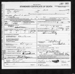
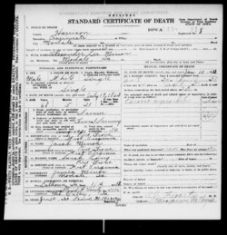
| Death | : | 26 Apr 1910 Ponca, Dixon County, Nebraska, USA |
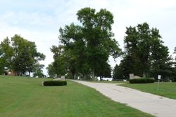
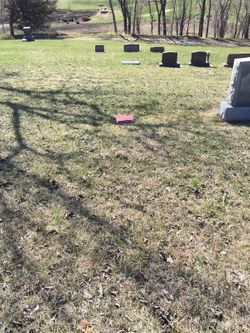
| Burial | : | Sorden Cemetery, Webster, Keokuk County, USA |
| Coordinate | : | 41.4575005, -92.1905975 |
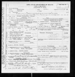
| Description | : | Jeremiah Miner was the son of Jacob and Sarah Ann (Long) Miner. On 9 March 1887 in Douglas, Nebraska, Jeremiah married Etta May Whipple, daughter of Charles and Elizabeth (Lute) Whipple. Jeremiah and Etta May became the parents of ten children: five boys and five girls. Jeremiah operated the ferry across the Missouri River near Ponca, Nebraska. On 24 April 1910 their log cabin burned, killing Etta and five of their children, with Jeremiah dying two days later as a result of burns he received in the fire. |
frequently asked questions (FAQ):
-
Where is Jeremiah Black Miner's memorial?
Jeremiah Black Miner's memorial is located at: Sorden Cemetery, Webster, Keokuk County, USA.
-
When did Jeremiah Black Miner death?
Jeremiah Black Miner death on 26 Apr 1910 in Ponca, Dixon County, Nebraska, USA
-
Where are the coordinates of the Jeremiah Black Miner's memorial?
Latitude: 41.4575005
Longitude: -92.1905975
Family Members:
Spouse

Children


Flowers:


Nearby Cemetories:
1. White Pigeon Cemetery
Keokuk County, USA
Coordinate: 41.4919014, -92.1710968
2. Porter Cemetery
Keokuk County, USA
Coordinate: 41.4963989, -92.2093964
3. Lutton Cemetery
South English, Keokuk County, USA
Coordinate: 41.4963989, -92.1342010
4. Bailey Cemetery
Keswick, Keokuk County, USA
Coordinate: 41.4449997, -92.2677994
5. Thomas Cemetery
Keokuk County, USA
Coordinate: 41.5049000, -92.1180000
6. Pleasant Hill Cemetery
Webster, Keokuk County, USA
Coordinate: 41.4039001, -92.1224976
7. Mount Zion Cemetery
Iowa County, USA
Coordinate: 41.5318985, -92.2014008
8. Armah Cemetery
North English, Iowa County, USA
Coordinate: 41.5314000, -92.2121000
9. South English Cemetery
South English, Keokuk County, USA
Coordinate: 41.4672012, -92.0860977
10. Johnson Cemetery
Sigourney, Keokuk County, USA
Coordinate: 41.3824997, -92.2485962
11. Saint Martin Evangelical Lutheran Cemetery
Keokuk County, USA
Coordinate: 41.4100075, -92.2971268
12. Humes Cemetery
Thornburg, Keokuk County, USA
Coordinate: 41.4085999, -92.2968979
13. White Oak Cemetery
Keokuk County, USA
Coordinate: 41.4738500, -92.3157000
14. Clary Cemetery
Sigourney, Keokuk County, USA
Coordinate: 41.3589080, -92.2000090
15. North English Cemetery
North English, Iowa County, USA
Coordinate: 41.5186000, -92.0858000
16. Walton Cemetery
Sigourney, Keokuk County, USA
Coordinate: 41.3583445, -92.1335126
17. English River Church of the Brethren Cemetery
South English, Keokuk County, USA
Coordinate: 41.4556313, -92.0383072
18. Sigourney East Cemetery
Sigourney, Keokuk County, USA
Coordinate: 41.3418999, -92.1992035
19. Saint Josephs Cemetery
What Cheer, Keokuk County, USA
Coordinate: 41.4007988, -92.3300018
20. Pleasant Grove Cemetery
Sigourney, Keokuk County, USA
Coordinate: 41.3405991, -92.2200012
21. Millersburg Cemetery
Millersburg, Iowa County, USA
Coordinate: 41.5744000, -92.1553000
22. County Home Cemetery
Sigourney, Keokuk County, USA
Coordinate: 41.3380013, -92.1770020
23. McFarlan Cemetery
What Cheer, Keokuk County, USA
Coordinate: 41.4085999, -92.3371964
24. Campbell Cemetery
North English, Iowa County, USA
Coordinate: 41.5539017, -92.0942001