
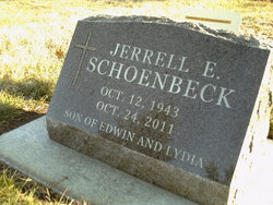
Jerrell E “Jerry” Schoenbeck
| Birth | : | 12 Oct 1943 Western, Saline County, Nebraska, USA |
| Death | : | 24 Oct 2011 Coralville, Johnson County, Iowa, USA |
| Burial | : | Saint Pauls Evangelical Lutheran Cemetery, Latimer, Franklin County, USA |
| Coordinate | : | 42.7652817, -93.3719406 |
| Description | : | LATIMER - Jerrell E. "Jerry" Schoenbeck, 68, of Coralville and formerly of Latimer, died Monday, Oct. 24, 2011, at the Windmill Manor Nursing Home in Coralville. Graveside funeral services will be held at noon Saturday, Oct. 29, 2011, at the St. Paul's Lutheran Cemetery in Latimer. Pastor Marvin Lorenz of the St. Paul's Lutheran Church in Latimer will officiate. Friends may call on the family starting at 11 a.m. Saturday, Oct. 29, at the Dugger Funeral Home, 320 East St. in Latimer. In lieu of flowers, memorial contributions in Jerry Shoenbeck's name may be made to the St. Paul Lutheran Church... Read More |
frequently asked questions (FAQ):
-
Where is Jerrell E “Jerry” Schoenbeck's memorial?
Jerrell E “Jerry” Schoenbeck's memorial is located at: Saint Pauls Evangelical Lutheran Cemetery, Latimer, Franklin County, USA.
-
When did Jerrell E “Jerry” Schoenbeck death?
Jerrell E “Jerry” Schoenbeck death on 24 Oct 2011 in Coralville, Johnson County, Iowa, USA
-
Where are the coordinates of the Jerrell E “Jerry” Schoenbeck's memorial?
Latitude: 42.7652817
Longitude: -93.3719406
Family Members:
Parent

Flowers:


Nearby Cemetories:
1. Saint Pauls Evangelical Lutheran Cemetery
Latimer, Franklin County, USA
Coordinate: 42.7652817, -93.3719406
2. Coulter Cemetery
Coulter, Franklin County, USA
Coordinate: 42.7388916, -93.3716736
3. Marion Center Cemetery
Latimer, Franklin County, USA
Coordinate: 42.7738991, -93.3178024
4. Saint Peter's Lutheran Church Cemetery
Coulter, Franklin County, USA
Coordinate: 42.7167015, -93.3803024
5. Saint Johns Lutheran Cemetery
Hampton, Franklin County, USA
Coordinate: 42.7197189, -93.3397217
6. Alexander Cemetery
Alexander, Franklin County, USA
Coordinate: 42.8041687, -93.4591675
7. Zion Reformed Church Cemetery
Franklin County, USA
Coordinate: 42.8413887, -93.3188934
8. Trinity Lutheran Cemetery
Hampton, Franklin County, USA
Coordinate: 42.7667007, -93.2518997
9. Morgan Cemetery
Morgan Township, Franklin County, USA
Coordinate: 42.6741982, -93.4100037
10. Old Chapin Cemetery
Chapin, Franklin County, USA
Coordinate: 42.8232994, -93.2624969
11. Mount Hope Cemetery
Morgan Township, Franklin County, USA
Coordinate: 42.6777992, -93.4792023
12. Holland Cemetery
Wisner Township, Franklin County, USA
Coordinate: 42.8638916, -93.4791718
13. Way Side Cemetery
Chapin, Franklin County, USA
Coordinate: 42.8293991, -93.2225037
14. Hampton Cemetery
Hampton, Franklin County, USA
Coordinate: 42.7452812, -93.1975021
15. Olson Cemetery
Popejoy, Franklin County, USA
Coordinate: 42.6383018, -93.4403000
16. Maynes Grove Cemetery
Hampton, Franklin County, USA
Coordinate: 42.6577988, -93.2514038
17. Richland Lutheran Cemetery
Thornton, Cerro Gordo County, USA
Coordinate: 42.9086113, -93.3683319
18. Graceland Cemetery
Rowan, Wright County, USA
Coordinate: 42.7453003, -93.5714035
19. Fairview Cemetery
Dows, Wright County, USA
Coordinate: 42.6511002, -93.5044022
20. Shobes Grove Cemetery
Franklin County, USA
Coordinate: 42.9000015, -93.2722168
21. Immanuel Reformed Cemetery
Belmond, Wright County, USA
Coordinate: 42.8635000, -93.5484000
22. Meservey Cemetery
Meservey, Franklin County, USA
Coordinate: 42.9080582, -93.4786072
23. Towle Cemetery
Geneva, Franklin County, USA
Coordinate: 42.6836014, -93.1785965
24. Richard Cemetery
Meservey, Cerro Gordo County, USA
Coordinate: 42.9089012, -93.4925003