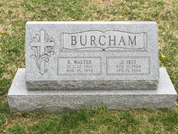
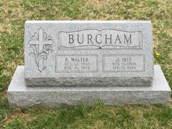
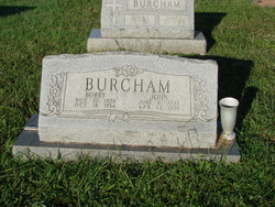
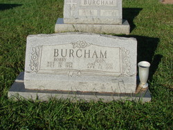
Jettie Iris Poplin Burcham
| Birth | : | 11 Nov 1908 Wilkes County, North Carolina, USA |
| Death | : | 18 Apr 2014 Nashville, Davidson County, Tennessee, USA |
| Burial | : | Mount Zion United Methodist Church Cemetery, Bel Air, Harford County, USA |
| Coordinate | : | 39.5475006, -76.3086014 |
| Description | : | Jettie Iris Burcham, age 105, of Nashville, TN, died Friday, April 18, 2014 at the Green Hill Health and Rehabilitation Center. She was born in Wilkes County, NC, on November 11, 1908 and moved with her parents and siblings to a farm in Harford County, MD, around 1919. She is survived by her three sons: Arthur and his wife, Eleanor, of Nashville, TN; Stephen and his wife, Betty, of Dandridge, TN; James and his wife, Rose Ann, of Upper Marlboro, MD; one daughter, Rosalie Holbrook and her husband, Kenneth, of Havre de Grace, MD; eight granddaughters, four grandsons, fourteen great-grandchildren;... Read More |
frequently asked questions (FAQ):
-
Where is Jettie Iris Poplin Burcham's memorial?
Jettie Iris Poplin Burcham's memorial is located at: Mount Zion United Methodist Church Cemetery, Bel Air, Harford County, USA.
-
When did Jettie Iris Poplin Burcham death?
Jettie Iris Poplin Burcham death on 18 Apr 2014 in Nashville, Davidson County, Tennessee, USA
-
Where are the coordinates of the Jettie Iris Poplin Burcham's memorial?
Latitude: 39.5475006
Longitude: -76.3086014
Family Members:
Parent
Spouse
Siblings
Children
Flowers:
Nearby Cemetories:
1. Mount Zion United Methodist Church Cemetery
Bel Air, Harford County, USA
Coordinate: 39.5475006, -76.3086014
2. Saint Matthews Lutheran Church Columbarium
Bel Air, Harford County, USA
Coordinate: 39.5440430, -76.3268720
3. Oak Grove Baptist Church Cemetery
Bel Air, Harford County, USA
Coordinate: 39.5548300, -76.2880200
4. Southampton Farm Cemetery
Southampton, Harford County, USA
Coordinate: 39.5486600, -76.3344700
5. Welcome Home Freewill Baptist Church Cemetery
Bel Air, Harford County, USA
Coordinate: 39.5689000, -76.3244800
6. Asbury Cemetery
Churchville, Harford County, USA
Coordinate: 39.5505981, -76.2686005
7. Dallam-Webster Family Cemetery
Bel Air, Harford County, USA
Coordinate: 39.5722400, -76.3339100
8. Christ Our King Presbyterian Church
Bel Air, Harford County, USA
Coordinate: 39.5165851, -76.3313539
9. Emmanuel Episcopal Church Columbarium
Bel Air, Harford County, USA
Coordinate: 39.5396020, -76.3546890
10. Calvary United Methodist Church Cemetery
Churchville, Harford County, USA
Coordinate: 39.5275002, -76.2632980
11. Bel Air Memorial Gardens
Bel Air, Harford County, USA
Coordinate: 39.5468000, -76.3617900
12. Hickory Baptist Church Cemetery
Forest Hill, Harford County, USA
Coordinate: 39.5779600, -76.3452000
13. Mount Tabor United Methodist Church Cemetery
Bel Air, Harford County, USA
Coordinate: 39.5863991, -76.3308029
14. Saint Ignatius Cemetery
Hickory, Harford County, USA
Coordinate: 39.5736008, -76.3550034
15. Churchville Presbyterian Church Cemetery
Churchville, Harford County, USA
Coordinate: 39.5602989, -76.2533035
16. Thomas Run Church Cemetery
Churchville, Harford County, USA
Coordinate: 39.5935000, -76.2923300
17. Church of the Holy Trinity Episcopal Cemetery
Churchville, Harford County, USA
Coordinate: 39.5606003, -76.2469025
18. Heavenly Waters Cemetery
Harford County, USA
Coordinate: 39.5293999, -76.3747025
19. Smiths Chapel United Methodist Church Cemetery
Churchville, Harford County, USA
Coordinate: 39.5532990, -76.2386017
20. Mount Carmel Cemetery
Emmorton, Harford County, USA
Coordinate: 39.4937200, -76.3224600
21. Clarks United Methodist Church Cemetery
Bel Air, Harford County, USA
Coordinate: 39.6036100, -76.3004600
22. Saint Mary's Episcopal Church Cemetery
Emmorton, Harford County, USA
Coordinate: 39.4879800, -76.3171100
23. David Lee Family Cemetery
Bel Air, Harford County, USA
Coordinate: 39.5319958, -76.3866033
24. Christ Church Cemetery
Forest Hill, Harford County, USA
Coordinate: 39.5744019, -76.3874969

