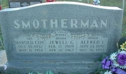
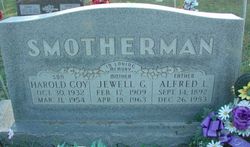
Jewell G. Willbanks Smotherman
| Birth | : | 17 Feb 1909 Howell County, Missouri, USA |
| Death | : | 18 Apr 1963 Howell County, Missouri, USA |
| Burial | : | Vandalia Cemetery, Porterville, Tulare County, USA |
| Coordinate | : | 36.0368900, -119.0049400 |
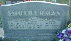
| Inscription | : | In Loving Memory Mother Married May 29 1926 |
| Description | : | Jewel G Wilbanks in the 1910 United States Federal Census Name: Jewel G Wilbanks Age in 1910: 1 Birth Date: 1909 [1909] Birthplace: Missouri Home in 1910: Sisson, Howell, Missouri, USA Race: White Gender: Female Relation to Head of House: Daughter Marital Status: Single Father's Name: John J Wilbanks Father's Birthplace: Missouri Mother's Name: Essie K Wilbanks Mother's Birthplace: Missouri Neighbors: View others on page Household Members Age Relationship John J Wilbanks 38 Head Essie K Wilbanks 19 Wife Mauddie R Wilbanks 15 Daughter John W Wilbanks Jr. 11 Son Mary J Wilbanks 9 Daughter Jewel G Wilbanks 1 Daughter |
frequently asked questions (FAQ):
-
Where is Jewell G. Willbanks Smotherman's memorial?
Jewell G. Willbanks Smotherman's memorial is located at: Vandalia Cemetery, Porterville, Tulare County, USA.
-
When did Jewell G. Willbanks Smotherman death?
Jewell G. Willbanks Smotherman death on 18 Apr 1963 in Howell County, Missouri, USA
-
Where are the coordinates of the Jewell G. Willbanks Smotherman's memorial?
Latitude: 36.0368900
Longitude: -119.0049400
Family Members:
Parent
Spouse
Siblings
Children
Nearby Cemetories:
1. Vandalia Cemetery
Porterville, Tulare County, USA
Coordinate: 36.0368900, -119.0049400
2. Saint Annes Cemetery
Porterville, Tulare County, USA
Coordinate: 36.0401030, -119.0294190
3. Home of Peace Cemetery
Porterville, Tulare County, USA
Coordinate: 36.0654297, -118.9956589
4. Hillcrest Cemetery
Porterville, Tulare County, USA
Coordinate: 36.0650291, -118.9909134
5. Porterville Cemetery
Porterville, Tulare County, USA
Coordinate: 36.0666695, -118.9950027
6. Zion Lutheran Church Cemetery
Terra Bella, Tulare County, USA
Coordinate: 35.9775391, -118.9989014
7. Frazier Valley Cemetery
Porterville, Tulare County, USA
Coordinate: 36.1448898, -118.9557037
8. Woodville Cemetery
Woodville, Tulare County, USA
Coordinate: 36.0944440, -119.1858330
9. Lindsay-Strathmore Cemetery
Lindsay, Tulare County, USA
Coordinate: 36.1977590, -119.0733430
10. Tule River Indian Reservation Lower Cemetery
Porterville, Tulare County, USA
Coordinate: 36.0238876, -118.7908325
11. Crabtree-Globe Cemetery
Springville, Tulare County, USA
Coordinate: 36.1329000, -118.8168200
12. Springville Cemetery
Springville, Tulare County, USA
Coordinate: 36.1329002, -118.8168182
13. Tule River Indian Reservation Upper Cemetery
Porterville, Tulare County, USA
Coordinate: 36.0451508, -118.7482834
14. Galley Mountain Cemetery
Tulare County, USA
Coordinate: 35.8894005, -118.8069000
15. Duncan-McDonald Cemetery
Springville, Tulare County, USA
Coordinate: 36.2013890, -118.7891670
16. Tailholt Boot Hill Cemetery
White River, Tulare County, USA
Coordinate: 35.8111110, -118.8452780
17. White River Cemetery
White River, Tulare County, USA
Coordinate: 35.8104350, -118.8412160
18. Tipton-Pixley Cemetery
Tipton, Tulare County, USA
Coordinate: 36.0505981, -119.3392029
19. Bear Creek Ranch Cemetery
Lindsay, Tulare County, USA
Coordinate: 36.2067200, -118.7338900
20. Exeter District Cemetery
Exeter, Tulare County, USA
Coordinate: 36.3103270, -119.1352330
21. Tulare Cemetery
Tulare, Tulare County, USA
Coordinate: 36.2057991, -119.3319016
22. Deep Creek Cemetery
Farmersville, Tulare County, USA
Coordinate: 36.3185997, -119.1958008
23. Hamilton Cemetery
Tulare County, USA
Coordinate: 36.3504110, -119.1063380
24. North Kern Cemetery
Delano, Kern County, USA
Coordinate: 35.7630560, -119.2580560

