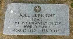
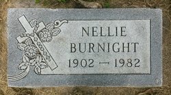
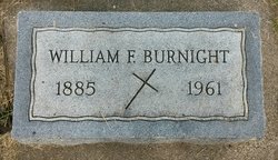
Joel "Mike" F. Burnight
| Birth | : | 13 Aug 1895 Akron, Plymouth County, Iowa, USA |
| Death | : | 9 Feb 1951 Chatsworth, Sioux County, Iowa, USA |
| Burial | : | Brown Cemetery, Hardy, Mercer County, USA |
| Coordinate | : | 37.3070800, -81.0265208 |
| Description | : | Joel F. "Mike" Burnight,55, of Chatsworth died February 9, 1951, following a heart attack. Mr. Burnight carried the mail between the post office and depot at Chatsworth and last Friday morning shortly before 9 he left his home to get the mail at the Post Office. He had gone but a short distance when he felt ill and stopped at the Henry Satthoff home where he died shortly after. Funeral services were held at St. Mary's church in Hawarden with Rev. Fr. R. Graf officiating. Rosary was said Sunday evening in the home at Chatsworth. Burial was St. Mary's cemetery under the... Read More |
frequently asked questions (FAQ):
-
Where is Joel "Mike" F. Burnight's memorial?
Joel "Mike" F. Burnight's memorial is located at: Brown Cemetery, Hardy, Mercer County, USA.
-
When did Joel "Mike" F. Burnight death?
Joel "Mike" F. Burnight death on 9 Feb 1951 in Chatsworth, Sioux County, Iowa, USA
-
Where are the coordinates of the Joel "Mike" F. Burnight's memorial?
Latitude: 37.3070800
Longitude: -81.0265208
Family Members:
Parent
Spouse
Siblings
Children
Flowers:
Nearby Cemetories:
1. Brown Cemetery
Hardy, Mercer County, USA
Coordinate: 37.3070800, -81.0265208
2. Bray Cemetery
Mercer County, USA
Coordinate: 37.3102989, -81.0258026
3. Potter's Shop Cemetery
Hardy, Mercer County, USA
Coordinate: 37.3134420, -81.0235750
4. Wagner Cemetery
Rocky Gap, Bland County, USA
Coordinate: 37.2839012, -81.0194016
5. Hogans Cemetery
Rocky Gap, Bland County, USA
Coordinate: 37.2789001, -81.0355988
6. Shields Cemetery
Rocky Gap, Bland County, USA
Coordinate: 37.2797012, -81.0438995
7. Elmore Cemetery
Mercer County, USA
Coordinate: 37.3363991, -81.0496979
8. Tynes and Ferguson Cemetery
Rocky Gap, Bland County, USA
Coordinate: 37.2785988, -81.0532990
9. Brown Cemetery
Mercer County, USA
Coordinate: 37.3438988, -81.0397034
10. Cooper Cemetery
Mercer County, USA
Coordinate: 37.3246994, -81.0783005
11. Crawford Cemetery
Mercer County, USA
Coordinate: 37.3535500, -81.0397300
12. Crawford Cemetery
Mercer County, USA
Coordinate: 37.3539009, -81.0406036
13. Dodson-Clark Cemetery
Bland County, USA
Coordinate: 37.2591000, -81.0045200
14. Clark Cemetery
Niday, Bland County, USA
Coordinate: 37.2561240, -81.0320940
15. Bivins Cemetery
Grapefield, Bland County, USA
Coordinate: 37.2557300, -81.0197300
16. Harvey Cemetery
Mercer County, USA
Coordinate: 37.3347015, -81.0819016
17. Cumiford and Stowers Cemetery
Rocky Gap, Bland County, USA
Coordinate: 37.2697420, -81.0735780
18. Comfort Cemetery
Bland County, USA
Coordinate: 37.2700005, -81.0746994
19. Lambert Cemetery
Giles County, USA
Coordinate: 37.2605400, -80.9888600
20. Lambert Family Cemetery
Niday, Bland County, USA
Coordinate: 37.2516057, -81.0311343
21. Shrader Cemetery
Niday, Bland County, USA
Coordinate: 37.2511000, -81.0322000
22. Sword Cemetery
Rocky Gap, Bland County, USA
Coordinate: 37.2675018, -81.0811005
23. Dunagan-Whittake Cemetery
Mercer County, USA
Coordinate: 37.3584210, -80.9898720
24. Shumate Cemetery
Bluefield, Mercer County, USA
Coordinate: 37.2909400, -81.1003800

