
Johann Jacob Bankert
| Birth | : | 25 Nov 1717 Rheinland-Pfalz, Germany |
| Death | : | 14 Mar 1789 Silver Run, Carroll County, Maryland, USA |
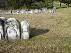
| Burial | : | Holy Three Kings Cemetery, Epiphany, Hanson County, USA |
| Coordinate | : | 43.8491100, -97.6603900 |
| Plot | : | no grave marker |
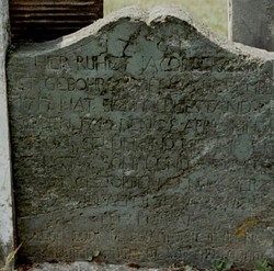
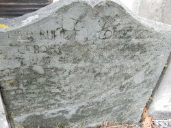
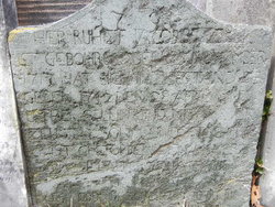
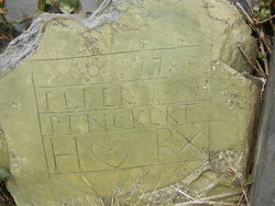
| Inscription | : | 1791 / HIER RUHET JACOB BENCKER /IST GEBOHREN DEN 25 NOVEMBER / 1717 HAT SICH IN EHESTAND BE/GEBEN 1742 DEN 28 APRIL MIT / ESTHER SELLIN UND MIT IHR ER=/ZEUGT 7 SOHN UND 7 TOCHTER / ER IST GESTORBEN DEN 14 MERZ / 1789 SEIN AL |
| Description | : | Large, weathy landowner in the Union Mills, MD area, where he operated a grist mill. Husband of Esther Christina Sells. Father of: Peter, Margareth, Johann Jacob, Jr., Johannes, Christopher, Catharina, Magdelena, Mary, Judith, Abraham, Henry and Esther.∼Married Ester Sell 4/28/1742 and had 7 sons and 7 daughters. There is no record of burial of Ester Sell Benkert but she is listed on the headstone as being buried with him. |
frequently asked questions (FAQ):
-
Where is Johann Jacob Bankert's memorial?
Johann Jacob Bankert's memorial is located at: Holy Three Kings Cemetery, Epiphany, Hanson County, USA.
-
When did Johann Jacob Bankert death?
Johann Jacob Bankert death on 14 Mar 1789 in Silver Run, Carroll County, Maryland, USA
-
Where are the coordinates of the Johann Jacob Bankert's memorial?
Latitude: 43.8491100
Longitude: -97.6603900
Family Members:
Parent
Spouse
Siblings

Children
Flowers:


Nearby Cemetories:
1. Holy Three Kings Cemetery
Epiphany, Hanson County, USA
Coordinate: 43.8491100, -97.6603900
2. Saint Pauls Cemetery
Miner County, USA
Coordinate: 43.8774986, -97.5691986
3. Pleasant Hill Cemetery
McCook County, USA
Coordinate: 43.8044014, -97.5702972
4. Hillside Cemetery
Spencer, McCook County, USA
Coordinate: 43.7681007, -97.5681000
5. Immanuel Lutheran Church Cemetery
McCook County, USA
Coordinate: 43.8338100, -97.5092500
6. Our Savior Danish Evangelical Lutheran Cemetery
Howard, Miner County, USA
Coordinate: 43.9426537, -97.5663223
7. Saint Peters Catholic Cemetery
Farmer, Hanson County, USA
Coordinate: 43.7305984, -97.6864014
8. Lakeside Cemetery
Edgerton Township, Hanson County, USA
Coordinate: 43.7308006, -97.6138992
9. Redstone Cemetery
Hanson County, USA
Coordinate: 43.8191986, -97.8289032
10. Canova Cemetery
Canova, Miner County, USA
Coordinate: 43.8925018, -97.4888992
11. Unityville Cemetery
McCook County, USA
Coordinate: 43.8182900, -97.4693900
12. Roswell Cemetery
Roswell, Miner County, USA
Coordinate: 43.9939003, -97.6919022
13. Spencer Cemetery
Spencer, McCook County, USA
Coordinate: 43.7085991, -97.5899963
14. Farwell Cemetery
Sanborn County, USA
Coordinate: 43.8788986, -97.8688965
15. Saint Nicholas Cemetery
Roswell, Miner County, USA
Coordinate: 44.0057793, -97.6929626
16. Graceland Cemetery
Fulton, Hanson County, USA
Coordinate: 43.7310982, -97.8114014
17. Erik Olson Cemetery
Salem, McCook County, USA
Coordinate: 43.8189011, -97.4278030
18. Fedora Cemetery
Fedora, Miner County, USA
Coordinate: 43.9996986, -97.7906036
19. Graceland Cemetery
Howard, Miner County, USA
Coordinate: 44.0003014, -97.5289001
20. IOOF Cemetery
Vilas, Miner County, USA
Coordinate: 44.0225067, -97.5940399
21. Sun Prairie Baptist Cemetery
Salem, McCook County, USA
Coordinate: 43.8466988, -97.4080963
22. Saint Josephs Cemetery
Howard, Miner County, USA
Coordinate: 44.0092010, -97.5105972
23. Saint Johns Lutheran Cemetery
Howard, Miner County, USA
Coordinate: 44.0106010, -97.5105972
24. Pleasant Hill Cemetery
Miner County, USA
Coordinate: 43.9248800, -97.4092650