
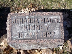

Johanna “Anna / Annie” Lynch Kinney
| Birth | : | 24 Jan 1852 Otonabee, Peterborough County, Ontario, Canada |
| Death | : | 20 Aug 1927 Bay City, Bay County, Michigan, USA |
| Burial | : | Gloucester General Cemetery, Gloucester, Mid-Coast Council, Australia |
| Coordinate | : | -32.0268401, 151.9645978 |
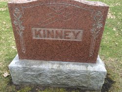
| Plot | : | Section 3 & 4 Old St. Pats |
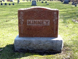
| Inscription | : | None |
| Description | : | Born Johanna Lynch in Otonabee township, Peterborough County, Ontario, Canada on January 24, 1852 to Michael and Johanna (Young) Lynch. She was married in May, 1870 to Francis Mader. according to the 1870 US federal census records for Lockport, Niagara, New York, where they lived as young newlyweds. Their oldest son, John, was born in Lockport. By 1873, they were living in the now defunct town of East Saginaw, Michigan, at the time of the birth of their second son, Francis. At some point in 1874, the couple had moved a few miles north to neighboring Bay City, Michigan, where he... Read More |
frequently asked questions (FAQ):
-
Where is Johanna “Anna / Annie” Lynch Kinney's memorial?
Johanna “Anna / Annie” Lynch Kinney's memorial is located at: Gloucester General Cemetery, Gloucester, Mid-Coast Council, Australia.
-
When did Johanna “Anna / Annie” Lynch Kinney death?
Johanna “Anna / Annie” Lynch Kinney death on 20 Aug 1927 in Bay City, Bay County, Michigan, USA
-
Where are the coordinates of the Johanna “Anna / Annie” Lynch Kinney's memorial?
Latitude: -32.0268401
Longitude: 151.9645978
Family Members:
Spouse
Children
Flowers:


Nearby Cemetories:
1. Gloucester General Cemetery
Gloucester, Mid-Coast Council, Australia
Coordinate: -32.0268401, 151.9645978
2. Barrington Pioneer Cemetery
Barrington, Mid-Coast Council, Australia
Coordinate: -31.9970030, 151.9047510
3. Copeland Cemetery
Copeland, Mid-Coast Council, Australia
Coordinate: -31.9693480, 151.8855570
4. Stratford Cemetery
Stratford, Mid-Coast Council, Australia
Coordinate: -32.1207810, 151.9421690
5. Wards River Cemetery
Wards River, Mid-Coast Council, Australia
Coordinate: -32.2191000, 151.9464000
6. Krambach General Cemetery
Krambach, Mid-Coast Council, Australia
Coordinate: -32.0723200, 152.2718800
7. Bo Bo General Cemetery
Burrell Creek, Mid-Coast Council, Australia
Coordinate: -31.9539720, 152.3104710
8. Killawarra Cemetery
Killawarra, Mid-Coast Council, Australia
Coordinate: -31.9025720, 152.2971260
9. Chichester Anglican Church
Mid-Coast Council, Australia
Coordinate: -32.1961800, 151.6202260
10. Banden Grove Cemetery
Banden Grove, Dungog Shire, Australia
Coordinate: -32.2964900, 151.7236800
11. Coolongolook General Cemetery
Coolongolook, Mid-Coast Council, Australia
Coordinate: -32.2083660, 152.3225200
12. Failford General Cemetery
Nabiac, Mid-Coast Council, Australia
Coordinate: -32.1109580, 152.3721880
13. Wingham General Cemetery
Wingham, Mid-Coast Council, Australia
Coordinate: -31.8794899, 152.3459320
14. Bendolba General & War Cemetery
Bendolba, Dungog Shire, Australia
Coordinate: -32.3209930, 151.7251180
15. Bendolba Anglican Cemetery
Bendolba, Dungog Shire, Australia
Coordinate: -32.3210790, 151.7249510
16. Worth Family Cemetery
Coolongolook, Mid-Coast Council, Australia
Coordinate: -32.2321050, 152.3154320
17. Marlee General Cemetery
Marlee, Mid-Coast Council, Australia
Coordinate: -31.8044200, 152.3137700
18. Quart Pot Cemetery
Banden Grove, Dungog Shire, Australia
Coordinate: -32.2779150, 151.6415950
19. Wingham Presbyterian Columbarium
Wingham, Mid-Coast Council, Australia
Coordinate: -31.8722840, 152.3657070
20. Stroud General Cemetery and Columbarium
Stroud, Mid-Coast Council, Australia
Coordinate: -32.4031170, 151.9756360
21. Stroud Anglican Cemetery
Stroud, Mid-Coast Council, Australia
Coordinate: -32.4052620, 151.9677280
22. Tinonee Cemetery
Tinonee, Mid-Coast Council, Australia
Coordinate: -31.9398537, 152.3989105
23. Wingham Anglican Columbarium
Wingham, Mid-Coast Council, Australia
Coordinate: -31.8711150, 152.3733670
24. The Bight Cemetery
Wingham, Mid-Coast Council, Australia
Coordinate: -31.8810160, 152.3841090