
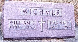
Johanna Dorothy “Hanna” Hunstock Wichmer
| Birth | : | 24 May 1891 Earling, Shelby County, Iowa, USA |
| Death | : | 4 Jun 1959 Iowa City, Johnson County, Iowa, USA |
| Burial | : | Mount Olivet Cemetery, Carroll, Carroll County, USA |
| Coordinate | : | 42.0536340, -94.8595510 |
| Description | : | June 5, 1959 - Funeral services will be at 9 am Saturday at St Josephs Church for Mrs. William J. Wichmer, 68, of Carroll who died of leukemia at 10:55 a.m. Thursday in the University of Iowa Hospitals at Iowa City. The Rt. Rev. Msgr. P. T. Lynch will ofter requiem mass Burial will be in Mt. Olivet Cemetery. Friends may call after 5 p.m. Friday at the Sharp Funer a 1 Home, where the rosary will be prayed at 8 and 9 p.m. Friday, with Msgr. Lynch leading the recitation at 8 o'clock. Mrs. Wichmer had been a patient... Read More |
frequently asked questions (FAQ):
-
Where is Johanna Dorothy “Hanna” Hunstock Wichmer's memorial?
Johanna Dorothy “Hanna” Hunstock Wichmer's memorial is located at: Mount Olivet Cemetery, Carroll, Carroll County, USA.
-
When did Johanna Dorothy “Hanna” Hunstock Wichmer death?
Johanna Dorothy “Hanna” Hunstock Wichmer death on 4 Jun 1959 in Iowa City, Johnson County, Iowa, USA
-
Where are the coordinates of the Johanna Dorothy “Hanna” Hunstock Wichmer's memorial?
Latitude: 42.0536340
Longitude: -94.8595510
Family Members:
Parent

Spouse

Siblings
Flowers:


Nearby Cemetories:
1. Mount Olivet Cemetery
Carroll, Carroll County, USA
Coordinate: 42.0536340, -94.8595510
2. Carroll City Cemetery
Carroll, Carroll County, USA
Coordinate: 42.0560963, -94.8599856
3. Holy Angels Cemetery
Carroll County, USA
Coordinate: 42.0014000, -94.9141998
4. Saint Francis Cemetery
Maple River, Carroll County, USA
Coordinate: 42.0969009, -94.9372025
5. Saint Marys Catholic Cemetery
Willey, Carroll County, USA
Coordinate: 41.9783363, -94.8212204
6. Holy Family Cemetery
Lidderdale, Carroll County, USA
Coordinate: 42.1178017, -94.7839966
7. West Lawn Cemetery
Glidden, Carroll County, USA
Coordinate: 42.0649986, -94.7406006
8. Immanuel Cemetery
Lidderdale, Carroll County, USA
Coordinate: 42.1389008, -94.8022003
9. Saint Augustine Cemetery
Halbur, Carroll County, USA
Coordinate: 42.0066986, -94.9744034
10. Our Lady Of Mount Carmel Cemetery
Mount Carmel, Carroll County, USA
Coordinate: 42.1547012, -94.9088974
11. Arcadia Cemetery
Arcadia Township, Carroll County, USA
Coordinate: 42.1000680, -95.0130550
12. East Liberty Cemetery
Lidderdale, Carroll County, USA
Coordinate: 42.1591988, -94.7636032
13. McCurdy Cemetery
Carroll County, USA
Coordinate: 41.9403000, -94.7649994
14. Saint Johns Catholic Cemetery
Arcadia, Carroll County, USA
Coordinate: 42.0855406, -95.0341577
15. Dickson Cemetery
Glidden Township, Carroll County, USA
Coordinate: 42.1074982, -94.6939011
16. Saint Bernards Cemetery
Breda, Carroll County, USA
Coordinate: 42.1786003, -94.9732971
17. Elba Cemetery
Templeton, Carroll County, USA
Coordinate: 41.9068985, -94.9131012
18. Sacred Heart Cemetery
Templeton, Carroll County, USA
Coordinate: 41.9138746, -94.9460994
19. Dedham Cemetery
Dedham, Carroll County, USA
Coordinate: 41.8993988, -94.8225021
20. Saint Josephs Cemetery
Dedham, Carroll County, USA
Coordinate: 41.8993988, -94.8210983
21. North Coon Cemetery
Carroll County, USA
Coordinate: 42.1260986, -94.6716995
22. Old Carrollton Cemetery
Carrollton, Carroll County, USA
Coordinate: 41.9233017, -94.7403030
23. Lanesboro Cemetery
Lanesboro, Carroll County, USA
Coordinate: 42.1810989, -94.7230988
24. Luckow Cemetery
Auburn, Sac County, USA
Coordinate: 42.2168999, -94.9266968