John A. Carson
| Birth | : | 28 Jun 1858 Clarke County, Iowa, USA |
| Death | : | 8 Sep 1920 Clarinda, Page County, Iowa, USA |
| Burial | : | Ottawa Cemetery, Ottawa, Clarke County, USA |
| Coordinate | : | 41.0231018, -93.5899963 |
| Plot | : | South Section, Row 13, Headstone 06 |
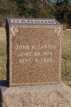
| Inscription | : | CARSON JOHN A. CARSON JUNE 28, 1858 SEPT. 8, 1920 |
| Description | : | The Osceola Tribune, Osceola, Iowa September 16, 1920, Page 2 It was with sorrow that the people of Woodburn and vicinity note the passing away of John Carson at Clarinda Thursday. He had received treatments at an Osceola hospital previous to his removal to Clarinda. He was well known, having spent nearly his entire life in Clarke county and will be greatly missed by his many relatives and friends. Transcribed as published by Karen Brewer. |
frequently asked questions (FAQ):
-
Where is John A. Carson's memorial?
John A. Carson's memorial is located at: Ottawa Cemetery, Ottawa, Clarke County, USA.
-
When did John A. Carson death?
John A. Carson death on 8 Sep 1920 in Clarinda, Page County, Iowa, USA
-
Where are the coordinates of the John A. Carson's memorial?
Latitude: 41.0231018
Longitude: -93.5899963
Family Members:
Parent
Siblings
Flowers:
Nearby Cemetories:
1. Ottawa Cemetery
Ottawa, Clarke County, USA
Coordinate: 41.0231018, -93.5899963
2. Saint Marys Cemetery
Woodburn, Clarke County, USA
Coordinate: 41.0190000, -93.6045000
3. Woodburn Cemetery
Woodburn, Clarke County, USA
Coordinate: 41.0080000, -93.6000000
4. Lewis Cemetery
Woodburn, Clarke County, USA
Coordinate: 40.9975014, -93.6485977
5. Horton Cemetery
Smyrna, Clarke County, USA
Coordinate: 40.9734192, -93.6321793
6. Last Chance Cemetery
Last Chance, Lucas County, USA
Coordinate: 40.9579000, -93.5535000
7. Rose Hill Cemetery
Lucas, Lucas County, USA
Coordinate: 41.0435000, -93.4985000
8. Wren Hill Pioneer Cemetery
Otter Creek Township, Lucas County, USA
Coordinate: 41.0887760, -93.5262200
9. Lost Chord Cemetery
Smyrna, Clarke County, USA
Coordinate: 40.9412689, -93.6088333
10. Smyrna Cemetery
Smyrna, Clarke County, USA
Coordinate: 40.9364014, -93.6156006
11. Old Smyrna Cemetery
Smyrna, Clarke County, USA
Coordinate: 40.9361000, -93.6159500
12. Harrison Cemetery
Liberty, Clarke County, USA
Coordinate: 41.1156000, -93.5896000
13. Walker Cemetery
Lucas County, USA
Coordinate: 41.1150017, -93.5567017
14. Twyford Cemetery
Liberty, Clarke County, USA
Coordinate: 41.1083295, -93.6670303
15. Goshen Baptist Cemetery
Lucas, Lucas County, USA
Coordinate: 40.9690000, -93.4710000
16. Brinegar Cemetery
Lucas, Lucas County, USA
Coordinate: 41.1015000, -93.4960000
17. Fry Hill Cemetery
Lucas, Lucas County, USA
Coordinate: 41.0425000, -93.4450000
18. Union Chapel Cemetery
Osceola, Clarke County, USA
Coordinate: 41.0811005, -93.7213974
19. Blair Cemetery
Smyrna, Clarke County, USA
Coordinate: 40.9098816, -93.6254883
20. Bethel Chapel Cemetery
Liberty, Clarke County, USA
Coordinate: 41.1395000, -93.5785000
21. Fisher-Webb Cemetery
Lucas County, USA
Coordinate: 40.9480000, -93.4713000
22. Jones Plot
Osceola, Clarke County, USA
Coordinate: 40.9692726, -93.7288284
23. Norwood Cemetery
Norwood, Lucas County, USA
Coordinate: 41.1173000, -93.4900000
24. Hebron Cemetery
Clarke County, USA
Coordinate: 40.9291992, -93.6911011

