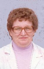
John A. Gabriel
| Birth | : | 2 May 1910 Edmunds County, South Dakota, USA |
| Death | : | 7 Oct 1984 Sioux Falls, Minnehaha County, South Dakota, USA |
| Burial | : | Saint Johns Cemetery, Conde, Spink County, USA |
| Coordinate | : | 45.1538860, -98.0888600 |
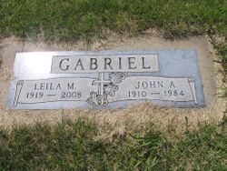
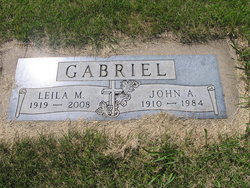
| Inscription | : | Gabriel Leila M. 1919-2008 John A. 1910-1984 |
| Description | : | Age: 74 Years *********************************************************** John is the son of Andrew Gabriel and Magdalena "Lena" Winderhalt. Andrew and Magdalena were both born in Russia and were married in Feb 1906 in Edmunds County, South Dakota. *********************************************************** 1920 US Census: Edmunds County, South Dakota 1930 US Census: Harmony Township, Edmunds County, South Dakota Jul 1934: married Rose B. Herrbach in Spink County, South Dakota 1940 US Census: Cresbard, Faulk County, South Dakota 1945 SD Census: Conde, Spink County, South Dakota May 1948: married Leila M. (Klapperich) Mommer in Brown County, South Dakota *********************************************************** |
frequently asked questions (FAQ):
-
Where is John A. Gabriel's memorial?
John A. Gabriel's memorial is located at: Saint Johns Cemetery, Conde, Spink County, USA.
-
When did John A. Gabriel death?
John A. Gabriel death on 7 Oct 1984 in Sioux Falls, Minnehaha County, South Dakota, USA
-
Where are the coordinates of the John A. Gabriel's memorial?
Latitude: 45.1538860
Longitude: -98.0888600
Family Members:
Parent
Spouse
Siblings
Children
Flowers:
Nearby Cemetories:
1. Saint Johns Cemetery
Conde, Spink County, USA
Coordinate: 45.1538860, -98.0888600
2. Conde Cemetery
Conde, Spink County, USA
Coordinate: 45.1617370, -98.0854110
3. Verdon Cemetery
Spink County, USA
Coordinate: 45.2332993, -98.0843964
4. Crandall Cemetery
Clark County, USA
Coordinate: 45.1528015, -97.9630966
5. Witt Crandall Cemetery
Crandall, Day County, USA
Coordinate: 45.1752870, -97.9517410
6. Verdon Cemetery
Verdon, Brown County, USA
Coordinate: 45.2551100, -98.1037410
7. Saint Josephs Cemetery
Turton, Spink County, USA
Coordinate: 45.0479660, -98.0899500
8. Sunnyside Cemetery
Turton, Spink County, USA
Coordinate: 45.0472600, -98.0849800
9. Scotland Cemetery
Day County, USA
Coordinate: 45.2580986, -97.9606018
10. Hutterville Colony Cemetery
Stratford, Brown County, USA
Coordinate: 45.2639000, -98.2139500
11. Saint Pauls Cemetery
Ferney, Brown County, USA
Coordinate: 45.3269005, -98.0927963
12. Baldwin Cemetery
Brentford, Spink County, USA
Coordinate: 45.1130981, -98.3392029
13. Plainview Cemetery
Brentford, Spink County, USA
Coordinate: 45.1782990, -98.3486023
14. East Rondell Cemetery
Stratford, Brown County, USA
Coordinate: 45.3053017, -98.2675018
15. Saint Ansgar Cemetery
Lily, Day County, USA
Coordinate: 45.1733017, -97.7994003
16. Saint Thomas Cemetery
Crocker, Clark County, USA
Coordinate: 45.0964012, -97.8088989
17. Oakwood Cemetery
Stratford, Brown County, USA
Coordinate: 45.2599983, -98.3516998
18. West Hanson Cemetery
Groton, Brown County, USA
Coordinate: 45.3570320, -98.1845470
19. Bethany Cemetery
Mellette, Spink County, USA
Coordinate: 45.2149086, -98.3806381
20. Clifton Cemetery
Clifton Township, Spink County, USA
Coordinate: 45.0106010, -98.3197021
21. Bethany Cemetery
Day County, USA
Coordinate: 45.2831001, -97.8174973
22. Sjurson Cemetery
Butler, Day County, USA
Coordinate: 45.2692990, -97.7768610
23. Our Saviors Lutheran West Cemetery
Clark County, USA
Coordinate: 45.1381000, -97.7372000
24. Doland Cemetery
Doland, Spink County, USA
Coordinate: 44.8993988, -98.0828018

