
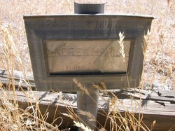
| Birth | : | 6 Jan 1864 Niles District, Alameda County, California, USA |
| Death | : | 21 Sep 1931 Parkfield, Monterey County, California, USA |
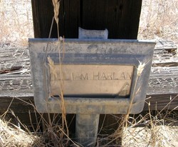
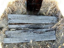
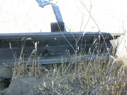
| Burial | : | Parkfield Cemetery, Monterey County, USA |
| Coordinate | : | 35.8666992, -120.4137726 |
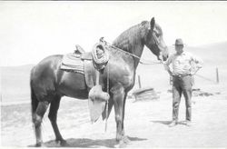
| Description | : | Steve Harrison (46893586) provided the following: Salinas Index-Journal (Salinas, California) September 24, 1931 (Thursday) Page 5, Column 4. "JOHN A. HARLAN, OF PARKFIELD, ANSWERS SUMMONS OF DEATH. The many friends of John A. Harlan, Parkfield pioneer, were shocked and grieved to learn of his death last Tuesday morning [September 21 in state death records]. Harlan retired the night before in the best of health and spirits, and from all indications, passed away during sleep without struggle or distress. John Harlan was born in Niles, Alameda county in 1864, the youngest son of William and Nancy Randal[l]... Read More |
frequently asked questions (FAQ):
-
Where is John Arthur Harlan's memorial?
John Arthur Harlan's memorial is located at: Parkfield Cemetery, Monterey County, USA.
-
When did John Arthur Harlan death?
John Arthur Harlan death on 21 Sep 1931 in Parkfield, Monterey County, California, USA
-
Where are the coordinates of the John Arthur Harlan's memorial?
Latitude: 35.8666992
Longitude: -120.4137726
Family Members:
Parent
Spouse
Siblings

Children
Flowers:


Nearby Cemetories:
1. Parkfield Cemetery
Monterey County, USA
Coordinate: 35.8666992, -120.4137726
2. Imusdale Cemetery
Monterey County, USA
Coordinate: 35.9247017, -120.5074997
3. Shandon Cemetery
San Luis Obispo County, USA
Coordinate: 35.6693993, -120.3525009
4. Pleasant Valley Cemetery
San Miguel, San Luis Obispo County, USA
Coordinate: 35.7181892, -120.6228485
5. Warthan Cemetery
Coalinga, Fresno County, USA
Coordinate: 36.0844180, -120.5279590
6. Estrella Adobe Cemetery
Paso Robles, San Luis Obispo County, USA
Coordinate: 35.6975080, -120.6399460
7. Mission San Miguel Cemetery
San Miguel, San Luis Obispo County, USA
Coordinate: 35.7452610, -120.6977370
8. San Miguel District Cemetery
San Miguel, San Luis Obispo County, USA
Coordinate: 35.7392006, -120.7013550
9. Pleasant Valley Cemetery
Coalinga, Fresno County, USA
Coordinate: 36.1504800, -120.2829100
10. Paso Robles District Cemetery
Paso Robles, San Luis Obispo County, USA
Coordinate: 35.6424700, -120.7035000
11. Saint James Episcopal Church Inurnment Garden
Paso Robles, San Luis Obispo County, USA
Coordinate: 35.6283460, -120.6929780
12. Creston Cemetery
Creston, San Luis Obispo County, USA
Coordinate: 35.5328640, -120.5121450
13. Hames Valley Cemetery
Bradley, Monterey County, USA
Coordinate: 35.8644660, -120.8505700
14. San Marcos Mennonite Cemetery
San Luis Obispo County, USA
Coordinate: 35.6874570, -120.7995160
15. Templeton Cemetery
Templeton, San Luis Obispo County, USA
Coordinate: 35.5714455, -120.7022095
16. Atascadero Pine Mountain Cemetery
Atascadero, San Luis Obispo County, USA
Coordinate: 35.4960835, -120.6565582
17. Clayton Cemetery
Priest Valley, San Benito County, USA
Coordinate: 36.2028008, -120.7285995
18. Chapel of the Roses Cemetery
Atascadero, San Luis Obispo County, USA
Coordinate: 35.5027340, -120.6881430
19. Adelaida Cemetery
San Luis Obispo County, USA
Coordinate: 35.6563988, -120.8728027
20. Anderson Akers Cemetery
Coalinga, Fresno County, USA
Coordinate: 36.2642690, -120.6226220
21. Willow Creek Mennonite Cemetery
Wilson Corner, San Luis Obispo County, USA
Coordinate: 35.5890410, -120.8215860
22. San Ardo Cemetery
San Ardo, Monterey County, USA
Coordinate: 36.0269089, -120.9120941
23. Williams-Duckworth Cemetery
Priest Valley, San Benito County, USA
Coordinate: 36.2356600, -120.7100800
24. Dove Cemetery
San Luis Obispo County, USA
Coordinate: 35.4482231, -120.6344299