
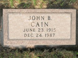
John Bernard Cain
| Birth | : | 23 Jun 1915 Carter, Beckham County, Oklahoma, USA |
| Death | : | 24 Dec 1987 Aberdeen, Brown County, South Dakota, USA |
| Burial | : | Riverside Memorial Park, Aberdeen, Brown County, USA |
| Coordinate | : | 45.4453011, -98.5117035 |
| Plot | : | Block E Lot 267 |
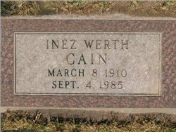
| Description | : | John Bernard Cain was the 7th child born to John William and Mary C Cain. John was born in Carter OK. on June 23th 1915. He attended school in the Carter area. John moved to South Dakota and worked in Agriculture in the Warner area. He married Inez I Werth on February 13th 1937 in Woonsocket South Dakota. They made their home at Omaha and Ogallala Nebraska. John entered the U.S.Army in 1943 and served in Alaska and received his Honorable Discharge in 1946. John and his wife moved to the family farm of Inez's father Albert Werth. ... Read More |
frequently asked questions (FAQ):
-
Where is John Bernard Cain's memorial?
John Bernard Cain's memorial is located at: Riverside Memorial Park, Aberdeen, Brown County, USA.
-
When did John Bernard Cain death?
John Bernard Cain death on 24 Dec 1987 in Aberdeen, Brown County, South Dakota, USA
-
Where are the coordinates of the John Bernard Cain's memorial?
Latitude: 45.4453011
Longitude: -98.5117035
Family Members:
Flowers:


Nearby Cemetories:
1. Riverside Memorial Park
Aberdeen, Brown County, USA
Coordinate: 45.4453011, -98.5117035
2. Sacred Heart Cemetery
Aberdeen, Brown County, USA
Coordinate: 45.4674988, -98.4627991
3. Saint Marys Cemetery
Aberdeen, Brown County, USA
Coordinate: 45.4858017, -98.4760971
4. Sunset Memorial Gardens
Aberdeen, Brown County, USA
Coordinate: 45.4599991, -98.3930969
5. Cooper Animal Clinic Pet Cemetery
Aberdeen, Brown County, USA
Coordinate: 45.4604063, -98.3883103
6. Saint Johns Lutheran Church Cemetery
Aberdeen, Brown County, USA
Coordinate: 45.3592600, -98.6183100
7. Warner Cemetery
Warner, Brown County, USA
Coordinate: 45.3272018, -98.5053024
8. Bath Memorial Cemetery
Bath, Brown County, USA
Coordinate: 45.4726900, -98.3294900
9. Scandinavia Lutheran Cemetery
Gem Township, Brown County, USA
Coordinate: 45.3569104, -98.3307271
10. East Gem Evangelical Lutheran Church Cemetery
Brown County, USA
Coordinate: 45.4007988, -98.2947006
11. Westport Cemetery
Westport, Brown County, USA
Coordinate: 45.6464005, -98.5017014
12. Pembrook Cemetery
Edmunds County, USA
Coordinate: 45.5127983, -98.7842026
13. Sacred Heart Cemetery
Westport, Brown County, USA
Coordinate: 45.6478200, -98.5015000
14. Richland Cemetery
Mina, Edmunds County, USA
Coordinate: 45.3563995, -98.7844009
15. Oakwood Cemetery
Stratford, Brown County, USA
Coordinate: 45.2599983, -98.3516998
16. East Rondell Cemetery
Stratford, Brown County, USA
Coordinate: 45.3053017, -98.2675018
17. Columbia Catholic Cemetery
Columbia, Brown County, USA
Coordinate: 45.6155400, -98.3051100
18. Lakeview Cemetery
Columbia, Brown County, USA
Coordinate: 45.6154000, -98.3045900
19. James Cemetery
Brown County, USA
Coordinate: 45.4575005, -98.1849976
20. Trinity Lutheran Cemetery
Mansfield, Spink County, USA
Coordinate: 45.2305400, -98.6570900
21. West Hanson Cemetery
Groton, Brown County, USA
Coordinate: 45.3570320, -98.1845470
22. Bethany Cemetery
Mellette, Spink County, USA
Coordinate: 45.2149086, -98.3806381
23. Truesdell Gravesite
Wetonka, McPherson County, USA
Coordinate: 45.6206885, -98.7668775
24. Wetonka Cemetery
Wetonka, McPherson County, USA
Coordinate: 45.6211800, -98.7794300