
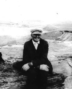
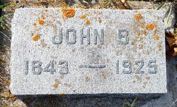

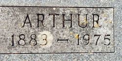
John Buchanan “Jack” Stewart
| Birth | : | 1843 Canada |
| Death | : | 22 Jun 1925 Liberty County, Montana, USA |
| Burial | : | Grand Army of the Republic Cemetery, Devils Lake, Ramsey County, USA |
| Coordinate | : | 48.1166290, -98.8409690 |
| Plot | : | Blk 4 Lot 9 Sp 11 Sec GAR Orig |
| Description | : | Liberty County Farmer, Chester, MT, 26 June 1925 Death Claims Old Pioneer The community was shocked and saddened by the death of John B. Stewart Monday morning. Death was caused by Bright's disease and complications. He was 82 years, four months and 22 days of age had resided in this neighborhood for 14 years past. He suffered from an attack of the flu two or three years ago and was not in good health at any time since, having heart trouble, which caused his death. He was a highly respected man and the sympathy of the entire community is extended to the bereaved ones. Funeral... Read More |
frequently asked questions (FAQ):
-
Where is John Buchanan “Jack” Stewart's memorial?
John Buchanan “Jack” Stewart's memorial is located at: Grand Army of the Republic Cemetery, Devils Lake, Ramsey County, USA.
-
When did John Buchanan “Jack” Stewart death?
John Buchanan “Jack” Stewart death on 22 Jun 1925 in Liberty County, Montana, USA
-
Where are the coordinates of the John Buchanan “Jack” Stewart's memorial?
Latitude: 48.1166290
Longitude: -98.8409690
Family Members:
Spouse
Children

Flowers:


Nearby Cemetories:
1. Grand Army of the Republic Cemetery
Devils Lake, Ramsey County, USA
Coordinate: 48.1166290, -98.8409690
2. Saint Josephs Catholic Cemetery
Devils Lake, Ramsey County, USA
Coordinate: 48.1163180, -98.8411680
3. Solwey Ranch Cemetery
Saint Michael, Benson County, USA
Coordinate: 48.0252590, -98.8041880
4. Grand Harbor Cemetery
Ramsey County, USA
Coordinate: 48.1585999, -98.9897003
5. Zion Cemetery
Stevens Township, Ramsey County, USA
Coordinate: 48.0894740, -98.6809810
6. Saint Michaels Catholic Church Cemetery
Saint Michael, Benson County, USA
Coordinate: 47.9828160, -98.8713040
7. Native American Cemetery
Saint Michael, Benson County, USA
Coordinate: 47.9823376, -98.8706338
8. Saint Benedicts Cemetery
Crary, Ramsey County, USA
Coordinate: 48.1932880, -98.6588680
9. Sacred Heart Catholic Cemetery
Crary, Ramsey County, USA
Coordinate: 48.0566490, -98.6388450
10. Crary Cemetery
Crary, Ramsey County, USA
Coordinate: 48.0564003, -98.6382980
11. Norway Lutheran Church Cemetery
Devils Lake, Ramsey County, USA
Coordinate: 48.1397282, -99.0712715
12. Spirit Lake Assembly of God Cemetery
Fort Totten, Benson County, USA
Coordinate: 47.9883687, -99.0012872
13. Fort Totten Post Cemetery
Fort Totten, Benson County, USA
Coordinate: 47.9775800, -98.9930800
14. Webster Cemetery
Ramsey County, USA
Coordinate: 48.2813988, -98.9180984
15. Fox Lake Cemetery
Ramsey County, USA
Coordinate: 48.2164001, -98.5843964
16. Dakotah Oyate Lutheran Cemetery
Tokio, Benson County, USA
Coordinate: 47.9118878, -98.8243692
17. Saint Paul Cemetery
Ramsey County, USA
Coordinate: 48.2164001, -99.1138992
18. Bdecan Presbyterian Cemetery
Tokio, Benson County, USA
Coordinate: 47.9057400, -98.8252200
19. Saints Peter and Paul Catholic Cemetery
Ramsey County, USA
Coordinate: 48.3320500, -98.8343920
20. Saint Jeromes Catholic Cemetery
Fort Totten, Benson County, USA
Coordinate: 47.9877960, -99.0993510
21. Schneider Farm Cemetery
Crary, Ramsey County, USA
Coordinate: 48.2519798, -98.5887000
22. Scandinavia Cemetery
Webster, Ramsey County, USA
Coordinate: 48.3249660, -98.7438332
23. Doyon Cemetery
Doyon, Ramsey County, USA
Coordinate: 48.0438995, -98.5314026
24. Presbyterian Cemetery
Ramsey County, USA
Coordinate: 48.2235985, -99.1371994