
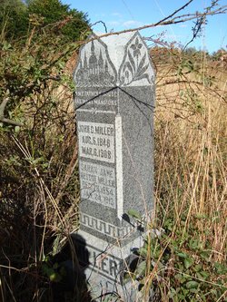

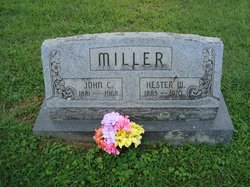
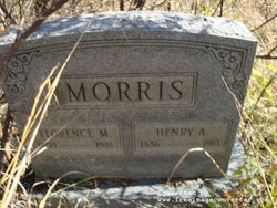
John C. Miller
| Birth | : | 5 Aug 1846 Virginia, USA |
| Death | : | 6 Mar 1908 Barbour County, West Virginia, USA |
| Burial | : | Joppa Baptist Church Cemetery, Levy County, USA |
| Coordinate | : | 29.5687630, -82.8978220 |
| Description | : | Married to Sarah Jane Nester Miller. |
frequently asked questions (FAQ):
-
Where is John C. Miller's memorial?
John C. Miller's memorial is located at: Joppa Baptist Church Cemetery, Levy County, USA.
-
When did John C. Miller death?
John C. Miller death on 6 Mar 1908 in Barbour County, West Virginia, USA
-
Where are the coordinates of the John C. Miller's memorial?
Latitude: 29.5687630
Longitude: -82.8978220
Family Members:
Spouse

Children

Flowers:


Nearby Cemetories:
1. Saint Alban's Episcopal Church Memorial Garden
Levy County, USA
Coordinate: 29.5463000, -82.8986000
2. Infant Owens Burial Site
Levy County, USA
Coordinate: 29.5439340, -82.9273391
3. Bethel Cemetery
Trenton, Gilchrist County, USA
Coordinate: 29.6311700, -82.8985600
4. Old Town Memorial Cemetery
Old Town, Dixie County, USA
Coordinate: 29.5893993, -82.9661026
5. Asbell Family Cemetery
Levy County, USA
Coordinate: 29.5465130, -82.8245630
6. Shady Grove Cemetery
Dixie County, USA
Coordinate: 29.5802994, -82.9768982
7. Trenton Cemetery
Trenton, Gilchrist County, USA
Coordinate: 29.6281600, -82.8408620
8. Hardeetown Methodist Cemetery
Chiefland, Levy County, USA
Coordinate: 29.4869900, -82.8806700
9. Mount Olive Cemetery
Chiefland, Levy County, USA
Coordinate: 29.4821508, -82.8723275
10. Chiefland Community Cemetery
Chiefland, Levy County, USA
Coordinate: 29.4816660, -82.8730550
11. Trenton Community Cemetery
Trenton, Gilchrist County, USA
Coordinate: 29.6303005, -82.8019028
12. Chiefland Cemetery
Chiefland, Levy County, USA
Coordinate: 29.4733028, -82.8499603
13. Pine Grove Baptist Church Cemetery
Levy County, USA
Coordinate: 29.5717773, -82.7759705
14. Adamsville Community Cemetery
Chiefland, Levy County, USA
Coordinate: 29.4780998, -82.8302994
15. Long Pond Baptist Church Cemetery
Levy County, USA
Coordinate: 29.4603990, -82.8976850
16. Jennings Lake Cemetery
Bell, Gilchrist County, USA
Coordinate: 29.6685150, -82.8427610
17. Overstreet Family Cemetery
Trenton, Gilchrist County, USA
Coordinate: 29.5841064, -82.7671814
18. Rogers Cemetery
Trenton, Gilchrist County, USA
Coordinate: 29.5950647, -82.7683150
19. Shady Grove Primitive Baptist Church Cemetery
Trenton, Gilchrist County, USA
Coordinate: 29.5776750, -82.7644730
20. Faith Baptist Cemetery
Old Town, Dixie County, USA
Coordinate: 29.5877480, -83.0318170
21. Priscilla Baptist Church Cemetery
Bell, Gilchrist County, USA
Coordinate: 29.6927300, -82.8984600
22. Midway Church of Christ Cemetery
Bell, Gilchrist County, USA
Coordinate: 29.6938500, -82.9026200
23. Old McCrabb Cemetery
Old Town, Dixie County, USA
Coordinate: 29.6769009, -82.9721985
24. Lee and Cooper Cemetery
Dixie County, USA
Coordinate: 29.5776672, -83.0481339