
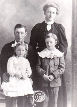
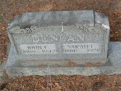
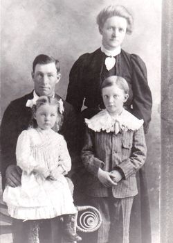
John Calvin Duncan
| Birth | : | 15 Jun 1869 Kansas, USA |
| Death | : | 17 Apr 1942 Wenatchee, Chelan County, Washington, USA |
| Burial | : | Cooloola Coast Crematorium, Monkland, Gympie Region, Australia |
| Coordinate | : | -26.2148230, 152.6868250 |
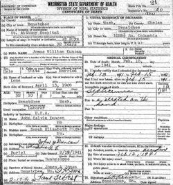
| Description | : | Washington Death Certificate Name John Calvin Duncan Death date 17 Apr 1942 Death place Wenatchee, Chelan, Washington Gender Male Age at death 72 years 10 months 2 days Estimated birth year 1870 Marital status Married Spouse name Sara H. Father name James Duncan Mother name Kilgore Film number 2023984 Digital GS number 4224152 Image number 1974 Reference number cn 48 children: James William Duncan b: 12 Apr 1909 d: 15 Feb 1941, Grant Graham (Lloyd D Duncan) b: 21 Jun 1915 d: 1 Apr 1997 |
frequently asked questions (FAQ):
-
Where is John Calvin Duncan's memorial?
John Calvin Duncan's memorial is located at: Cooloola Coast Crematorium, Monkland, Gympie Region, Australia.
-
When did John Calvin Duncan death?
John Calvin Duncan death on 17 Apr 1942 in Wenatchee, Chelan County, Washington, USA
-
Where are the coordinates of the John Calvin Duncan's memorial?
Latitude: -26.2148230
Longitude: 152.6868250
Family Members:
Parent
Spouse
Children

Flowers:


Nearby Cemetories:
1. Cooloola Coast Crematorium
Monkland, Gympie Region, Australia
Coordinate: -26.2148230, 152.6868250
2. Gympie Cemetery
Gympie, Gympie Region, Australia
Coordinate: -26.1749860, 152.6530570
3. Kandanga Cemetery
Kandanga, Gympie Region, Australia
Coordinate: -26.3842440, 152.6888120
4. Pomona Cemetery
Pomona, Noosa Shire, Australia
Coordinate: -26.3441600, 152.8530740
5. Tozer Park Cemetery (Defunct)
Gympie, Gympie Region, Australia
Coordinate: -26.0008330, 152.7438890
6. Neerdie Cemetery
Gympie, Gympie Region, Australia
Coordinate: -26.0008540, 152.7442570
7. Gunalda Cemetery
Gunalda, Gympie Region, Australia
Coordinate: -25.9877920, 152.5557680
8. Cooroy Cemetery
Cooroy, Noosa Shire, Australia
Coordinate: -26.4095520, 152.9143240
9. Dickabram Cemetery
Miva, Gympie Region, Australia
Coordinate: -25.9604510, 152.4848260
10. Cooloola Coast Cemetery
Cooloola Cove, Gympie Region, Australia
Coordinate: -25.9831920, 152.9677170
11. Gheerulla Cemetery
Gheerulla, Sunshine Coast Council, Australia
Coordinate: -26.5538100, 152.7713320
12. Tewantin Cemetery
Tewantin, Noosa Shire, Australia
Coordinate: -26.3950054, 153.0254472
13. Eumundi Cemetery
Eumundi, Sunshine Coast Council, Australia
Coordinate: -26.4913680, 152.9405570
14. Munna Creek Cemetery
Gundiah, Fraser Coast Region, Australia
Coordinate: -25.8943010, 152.4806150
15. Kilkivan Cemetery
Kilkivan, Gympie Region, Australia
Coordinate: -26.1072030, 152.2758930
16. Yandina Cemetery
Yandina, Sunshine Coast Council, Australia
Coordinate: -26.5720000, 152.9570000
17. Mapleton Cemetery
Mapleton, Sunshine Coast Council, Australia
Coordinate: -26.6241030, 152.8479884
18. Kulangoor Lawn Cemetery
Kulangoor, Sunshine Coast Council, Australia
Coordinate: -26.5884880, 152.9647280
19. Deborah Cemetery
Netherby, Fraser Coast Region, Australia
Coordinate: -25.7827119, 152.4940048
20. Nambour Garden Lawn Cemetery
Nambour, Sunshine Coast Council, Australia
Coordinate: -26.6116920, 152.9700810
21. Gregson & Weight Chapel & Crematorium
Nambour, Sunshine Coast Council, Australia
Coordinate: -26.6156420, 152.9649380
22. Nambour General Cemetery
Nambour, Sunshine Coast Council, Australia
Coordinate: -26.6156180, 152.9713150
23. Flaxton Cemetery
Flaxton, Sunshine Coast Council, Australia
Coordinate: -26.6617420, 152.8731570
24. Tiaro Cemetery
Tiaro, Fraser Coast Region, Australia
Coordinate: -25.7173650, 152.5856850