
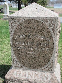
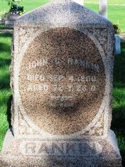
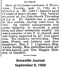
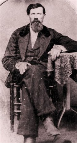
John Campbell Rankin
| Birth | : | 9 Aug 1828 Harrison County, Indiana, USA |
| Death | : | 4 Sep 1900 Indiana, Marion County, Iowa, USA |
| Burial | : | IOOF Cemetery, Grand Junction, Mesa County, USA |
| Coordinate | : | 39.0447500, -108.5679500 |
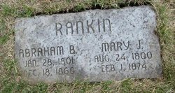
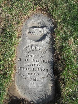
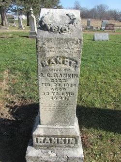
| Description | : | John was a son of Abraham Rankin & Mary J. Henderson. He was married to Nancy Burgess & Lydia Rothrock, who was buried in DePauw, Ind. |
frequently asked questions (FAQ):
-
Where is John Campbell Rankin's memorial?
John Campbell Rankin's memorial is located at: IOOF Cemetery, Grand Junction, Mesa County, USA.
-
When did John Campbell Rankin death?
John Campbell Rankin death on 4 Sep 1900 in Indiana, Marion County, Iowa, USA
-
Where are the coordinates of the John Campbell Rankin's memorial?
Latitude: 39.0447500
Longitude: -108.5679500
Family Members:
Parent
Spouse
Siblings

Children
Flowers:


Nearby Cemetories:
1. IOOF Cemetery
Grand Junction, Mesa County, USA
Coordinate: 39.0447500, -108.5679500
2. Masonic Cemetery
Grand Junction, Mesa County, USA
Coordinate: 39.0442276, -108.5670471
3. Veterans Cemetery
Grand Junction, Mesa County, USA
Coordinate: 39.0444946, -108.5690918
4. Saint Anthony Cemetery
Grand Junction, Mesa County, USA
Coordinate: 39.0454000, -108.5660000
5. Ohr Shalom Cemetery
Grand Junction, Mesa County, USA
Coordinate: 39.0460000, -108.5665000
6. Calvary Cemetery
Grand Junction, Mesa County, USA
Coordinate: 39.0456009, -108.5653000
7. Fair View Cemetery
Grand Junction, Mesa County, USA
Coordinate: 39.0465000, -108.5660000
8. Orchard Mesa Cemetery
Grand Junction, Mesa County, USA
Coordinate: 39.0426500, -108.5664000
9. Municipal Cemetery
Grand Junction, Mesa County, USA
Coordinate: 39.0477028, -108.5673676
10. Potters Field
Grand Junction, Mesa County, USA
Coordinate: 39.0413284, -108.5700989
11. Ross Cemetery
Grand Junction, Mesa County, USA
Coordinate: 39.0695660, -108.5637030
12. Teller Indian School Cemetery
Grand Junction, Mesa County, USA
Coordinate: 39.0631400, -108.5316130
13. Veterans Memorial Cemetery of Western Colorado
Grand Junction, Mesa County, USA
Coordinate: 39.0631447, -108.5261002
14. Saint Matthews Episcopal Church Memorial Garden
Grand Junction, Mesa County, USA
Coordinate: 39.1021440, -108.5422860
15. Memorial Gardens
Grand Junction, Mesa County, USA
Coordinate: 39.0790329, -108.5022278
16. Immaculate Heart of Mary Columbarium
Grand Junction, Mesa County, USA
Coordinate: 39.1195000, -108.5600000
17. Final Paws Pet Cemetery
Grand Junction, Mesa County, USA
Coordinate: 39.1205000, -108.6240000
18. Little Park Cemetery
Grand Junction, Mesa County, USA
Coordinate: 38.9863500, -108.6604500
19. Crown Point Cemetery
Grand Junction, Mesa County, USA
Coordinate: 39.1425018, -108.6175003
20. Whitewater Cemetery
Whitewater, Mesa County, USA
Coordinate: 38.9818993, -108.4357986
21. Glade Park Cemetery
Mesa County, USA
Coordinate: 39.0074997, -108.7382965
22. Palisade Cemetery
Palisade, Mesa County, USA
Coordinate: 39.0999000, -108.3980000
23. Sacred Heart Cemetery
Fruita, Mesa County, USA
Coordinate: 39.1721992, -108.7292023
24. Elmwood Cemetery
Fruita, Mesa County, USA
Coordinate: 39.1739006, -108.7339020