
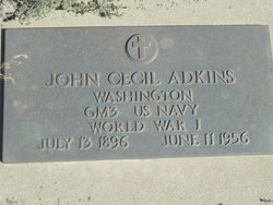
John Cecil Adkins
| Birth | : | 13 Jul 1896 Clinton, Henry County, Missouri, USA |
| Death | : | 11 Jun 1956 Coulee Dam, Okanogan County, Washington, USA |
| Burial | : | Highland Cemetery, Douglas County, USA |
| Coordinate | : | 47.6120000, -119.5064000 |
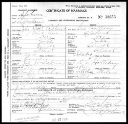
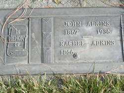
| Description | : | GM3 US Navy WW1, Bur. 14 Jun 1956. m: 27 Oct 1926 in Spokane Co, WA Washington Death Certificate name: John Cecil Adkins death date: 11 Jun 1956 death place: Coulee Dam, Okanogan, Washington gender: Male age at death: 59 years estimated birth year: 1897 father's name:John W. Adkins mother's name:Rachel Parks |
frequently asked questions (FAQ):
-
Where is John Cecil Adkins's memorial?
John Cecil Adkins's memorial is located at: Highland Cemetery, Douglas County, USA.
-
When did John Cecil Adkins death?
John Cecil Adkins death on 11 Jun 1956 in Coulee Dam, Okanogan County, Washington, USA
-
Where are the coordinates of the John Cecil Adkins's memorial?
Latitude: 47.6120000
Longitude: -119.5064000
Family Members:
Parent

Spouse
Flowers:


Nearby Cemetories:
1. Highland Cemetery
Douglas County, USA
Coordinate: 47.6120000, -119.5064000
2. Danish Cemetery
Douglas County, USA
Coordinate: 47.6856003, -119.4360962
3. Saint Andrews Cemetery
Douglas County, USA
Coordinate: 47.6786003, -119.4135971
4. Jameson Cemetery
Douglas County, USA
Coordinate: 47.6857986, -119.6624985
5. Old Pioneer Cemetery
Coulee City, Grant County, USA
Coordinate: 47.6267014, -119.2742004
6. Saint Hubert Catholic Cemetery
Douglas County, USA
Coordinate: 47.5988880, -119.7481940
7. Mold Cemetery
Douglas County, USA
Coordinate: 47.7433014, -119.3181000
8. Happy Home Cemetery
Farmer, Douglas County, USA
Coordinate: 47.6268997, -119.8125000
9. Evangelical Emanuel Cemetery
Douglas County, USA
Coordinate: 47.5764008, -119.8107986
10. Jean Cemetery
Mansfield, Douglas County, USA
Coordinate: 47.8292999, -119.4916000
11. Mansfield Cemetery
Mansfield, Douglas County, USA
Coordinate: 47.8088880, -119.6508330
12. Valley View Memorial Park
Soap Lake, Grant County, USA
Coordinate: 47.3870080, -119.4692050
13. Stratford Cemetery
Stratford, Grant County, USA
Coordinate: 47.4245000, -119.2980000
14. Buckingham Cemetery
Douglas County, USA
Coordinate: 47.8669014, -119.6286011
15. Hartline Cemetery
Hartline, Grant County, USA
Coordinate: 47.6845460, -119.0953800
16. Slack Cemetery
Douglas County, USA
Coordinate: 47.5283012, -119.9180984
17. Ephrata Cemetery
Ephrata, Grant County, USA
Coordinate: 47.3187447, -119.5584488
18. Saint Rose of Lima Catholic Cemetery
Ephrata, Grant County, USA
Coordinate: 47.3177770, -119.5583330
19. Douglas Lutheran Cemetery
Douglas County, USA
Coordinate: 47.6189003, -119.9614029
20. Wilson Creek Cemetery
Wilson Creek, Grant County, USA
Coordinate: 47.4307730, -119.1286290
21. Fletcher Cemetery
Douglas County, USA
Coordinate: 47.7430992, -119.9403000
22. Welsh Cemetery
Grant County, USA
Coordinate: 47.7139015, -119.0447006
23. Kummer Cemetery
Waterville, Douglas County, USA
Coordinate: 47.6559000, -120.0332000
24. Saint Johns Cemetery
Grant County, USA
Coordinate: 47.7863998, -119.0391998