
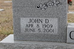

John D. Crane
| Birth | : | 8 Apr 1909 |
| Death | : | 5 Jun 2001 |
| Burial | : | Sunset Memory Gardens, Parkersburg, Wood County, USA |
| Coordinate | : | 39.2496986, -81.5911026 |
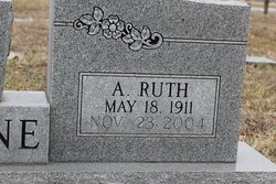
| Description | : | Obituary: Jefferson City Post Tribune Thursday, June 7, 2001 John D. Crane, 92, California, died June 5, 2001, at Cox Medical Center, Springfield. He was born April 8, 1909, near Ulman, a son of David T. and Alta Thompson Crane. He was married July 6, 1929, in Old Linn Creek, to Ruth Francis, who survives at the home. He was shed foreman in California for the Missouri Highway Department, retiring in 1972 after 43 years. He farmed part time. He was a member of First Christian Church, California, where he served as deacon. He attended Old Linn Creek... Read More |
frequently asked questions (FAQ):
-
Where is John D. Crane's memorial?
John D. Crane's memorial is located at: Sunset Memory Gardens, Parkersburg, Wood County, USA.
-
When did John D. Crane death?
John D. Crane death on 5 Jun 2001 in
-
Where are the coordinates of the John D. Crane's memorial?
Latitude: 39.2496986
Longitude: -81.5911026
Family Members:
Parent
Spouse
Siblings
Children

Flowers:


Nearby Cemetories:
1. Sunset Memory Gardens
Parkersburg, Wood County, USA
Coordinate: 39.2496986, -81.5911026
2. Tracewell Cemetery
Parkersburg, Wood County, USA
Coordinate: 39.2498000, -81.5870000
3. Posey Cemetery
Lubeck, Wood County, USA
Coordinate: 39.2437860, -81.5980020
4. Old Pest-House Cemetery
Parkersburg, Wood County, USA
Coordinate: 39.2581200, -81.5713960
5. River Hill Cemetery
Blennerhassett, Wood County, USA
Coordinate: 39.2636300, -81.6094400
6. Maddox Cemetery
Blennerhassett, Wood County, USA
Coordinate: 39.2608170, -81.6126500
7. Blennerhassett Family Burial Grounds
Blennerhassett Island View Addition, Wood County, USA
Coordinate: 39.2716217, -81.6009064
8. Bethel Baptist Church Cemetery
Parkersburg, Wood County, USA
Coordinate: 39.2511700, -81.6239900
9. Trinity Episcopal Church Columbarium
Parkersburg, Wood County, USA
Coordinate: 39.2665240, -81.5614570
10. Holliday Cemetery
Parkersburg, Wood County, USA
Coordinate: 39.2619019, -81.5560989
11. Cedarville Cemetery
Washington County, USA
Coordinate: 39.2769012, -81.6081009
12. Tavenner Cemetery
Parkersburg, Wood County, USA
Coordinate: 39.2546997, -81.5507965
13. Wright Cemetery
Parkersburg, Wood County, USA
Coordinate: 39.2374340, -81.5496962
14. Evergreen Cemetery South
South Parkersburg, Wood County, USA
Coordinate: 39.2442017, -81.5460968
15. Lubeck Cemetery
Lubeck, Wood County, USA
Coordinate: 39.2368400, -81.6337400
16. Riverview Cemetery
Parkersburg, Wood County, USA
Coordinate: 39.2735020, -81.5543890
17. Mathews Cemetery
Wood County, USA
Coordinate: 39.2500000, -81.5413971
18. Good Shepherd Episcopal Church Columbarium
Wood County, USA
Coordinate: 39.2670300, -81.5464980
19. Rockland Cemetery
Belpre, Washington County, USA
Coordinate: 39.2813988, -81.6200027
20. DeSales Heights Convent
Parkersburg, Wood County, USA
Coordinate: 39.2763700, -81.5535050
21. Saint Francis Xavier Catholic Cemetery
Parkersburg, Wood County, USA
Coordinate: 39.2703018, -81.5430984
22. Pleasant View Cemetery
Pettyville, Wood County, USA
Coordinate: 39.2075300, -81.5770100
23. Parkersburg Memorial Gardens
Parkersburg, Wood County, USA
Coordinate: 39.2798310, -81.5491430
24. First Lutheran Church Columbarium
Parkersburg, Wood County, USA
Coordinate: 39.2729370, -81.5365440