
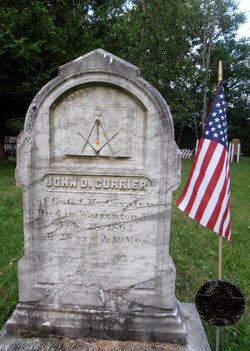
John D Currier
| Birth | : | Apr 1838 Fort Fairfield, Aroostook County, Maine, USA |
| Death | : | 28 Feb 1864 Warrenton, Fauquier County, Virginia, USA |
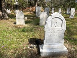
| Burial | : | Thorndike Cemetery, South Thomaston, Knox County, USA |
| Coordinate | : | 44.0263100, -69.1251100 |
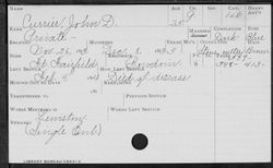
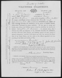
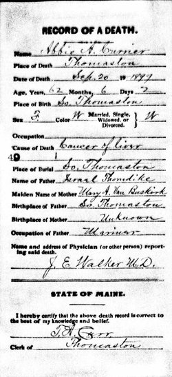
| Description | : | John D Currier (1838-1864) Husband of Abbie A Thorndike Currier, m 15 Sep 1857 Rockland ME Father of (see 1870 Census) - Walter H Currier b abt 1860 - John D Currier b abt 1862 Resided South Thomaston ME 1860 Occupation: Stone cutter John D Currier, Civil War Soldier Regiment: 1st Regiment, Maine Cavalry Side: Union Company: G Soldier's Rank In: Private Soldier's Rank Out: Private Alternate name: Currier, John B. Film Number:M543 roll 5 Notes: Original filed under John D./Currier Died 28 Feb 1864 Warrenton VA AE 25 ys 10 ms |
frequently asked questions (FAQ):
-
Where is John D Currier's memorial?
John D Currier's memorial is located at: Thorndike Cemetery, South Thomaston, Knox County, USA.
-
When did John D Currier death?
John D Currier death on 28 Feb 1864 in Warrenton, Fauquier County, Virginia, USA
-
Where are the coordinates of the John D Currier's memorial?
Latitude: 44.0263100
Longitude: -69.1251100
Family Members:
Spouse
Children


Nearby Cemetories:
1. Thorndike Cemetery
South Thomaston, Knox County, USA
Coordinate: 44.0263100, -69.1251100
2. Ocean View Cemetery
South Thomaston, Knox County, USA
Coordinate: 44.0217018, -69.1306000
3. Forest Hill Cemetery
Spruce Head, Knox County, USA
Coordinate: 44.0139008, -69.1436005
4. Village Cemetery
South Thomaston, Knox County, USA
Coordinate: 44.0527573, -69.1213608
5. Ash Point Cemetery
Owls Head, Knox County, USA
Coordinate: 44.0500670, -69.0854180
6. Owls Head Cemetery
Owls Head, Knox County, USA
Coordinate: 44.0544350, -69.0870020
7. Westbrook Street Cemetery
South Thomaston, Knox County, USA
Coordinate: 44.0589880, -69.1581040
8. Anderson Cemetery
Knox County, USA
Coordinate: 44.0704382, -69.1567917
9. Ginn Point Cemetery
Owls Head, Knox County, USA
Coordinate: 44.0637630, -69.0735320
10. Jewish Cemetery
Owls Head, Knox County, USA
Coordinate: 44.0798990, -69.1055150
11. Hall Cemetery
Owls Head, Knox County, USA
Coordinate: 44.0801180, -69.1054900
12. Goulding Cemetery
Owls Head, Knox County, USA
Coordinate: 44.0804308, -69.1047585
13. MacPhail Cemetery
Owls Head, Knox County, USA
Coordinate: 44.0805360, -69.1048570
14. North Parish Cemetery
Saint George, Knox County, USA
Coordinate: 44.0194900, -69.2028300
15. Robinson Yard
Cushing, Knox County, USA
Coordinate: 44.0391000, -69.2077730
16. Butler Cemetery
South Thomaston, Knox County, USA
Coordinate: 44.0873196, -69.1359382
17. Rose Hill Cemetery
Owls Head, Knox County, USA
Coordinate: 44.0743200, -69.0710640
18. Old Meeting House Cemetery
Cushing, Knox County, USA
Coordinate: 44.0274960, -69.2123030
19. Ingraham Cemetery
Owls Head, Knox County, USA
Coordinate: 44.0887740, -69.1130220
20. Elm Grove Cemetery
Thomaston, Knox County, USA
Coordinate: 44.0811880, -69.1761550
21. Holiday Beach Cemetery
Owls Head, Knox County, USA
Coordinate: 44.0746010, -69.0622210
22. Thomaston Village Cemetery
Thomaston, Knox County, USA
Coordinate: 44.0833015, -69.1757965
23. Thomaston State Prison Cemetery
Knox County, USA
Coordinate: 44.0757510, -69.1927230
24. Saint Johns Cemetery
Thomaston, Knox County, USA
Coordinate: 44.0853004, -69.1781006